Fissure 8 flow front, June 2, 2018: USGS scientists on HVO’s overflight this morning (June 2) captured this image of the fissure 8 flow front as it advanced west along Highway 132. Around the time of this photo, 7:15 a.m. HST, the flow front was approximately 100 yards west of the Hwy 132/137 intersection and advancing along a broad front over 300 yards in width extending both north and south of Highway 132. PC: USGS HVO
This news story will be updated throughout the day as new information becomes available and new articles will be added to the website’s “News” section. Previous information about ongoing events can be found in Big Island Now’s “Volcano Blog” section.
Sunday, June 2, 2018, at 7:45 p.m.
Vigorous eruption of lava continues from the lower East Rift Zone (LERZ) fissure system in the area of Leilani Estates and Lanipuna Gardens.
Sen. Kahele posted this picture of Kapoho around 7 p.m. on Sunday, June 3, 2018.
Fissure 8 fountaining persisted throughout the day to heights up to 220 feet, and the channelized flow continued to deliver lava northeast along Highway 132 to the Kapoho area. Lava is advancing along a 0.5-mile-wide front towards the ocean at Kapoho Bay between Kapoho Beach Road and Kapoho Kai Drive. As of 5:45 p.m., the lava flow was about 245 yards from the ocean at its closest approach point. Other branches of the Fissure 8 lava flow were inactive.
Click to enlarge
All other fissures are inactive, although observers on the late afternoon overflight noted abundant gas emission from Fissures 9 & 10 and incandescence without fountaining at fissures 16 & 18.
ARTICLE CONTINUES BELOW AD
ARTICLE CONTINUES BELOW AD
Pele’s hair and other lightweight volcanic glass from high fountaining of Fissure 8 are falling downwind of the fissure and accumulating on the ground within Leilani Estates. Winds may waft lighter particles to greater distances. Residents are urged to minimize exposure to these volcanic particles, which can cause skin and eye irritation similar to volcanic ash.
Kīlauea Volcano Summit
Earthquake activity at the summit was high overnight and through the day. A moderate earthquake (5.5 preliminary) resulting from a volcanic explosion and continued collapse around Halemaumau occurred at 3:50 p.m. National Weather Service radar observations confirmed an ash column was produced and reached 8,000 ft. asl.
Volcanic gas emissions at the summit remain high.
Sunday, June 2, 2018, at 6:30 p.m.
ARTICLE CONTINUES BELOW AD
At the Civil Defense press briefing for Sunday, June 3, 2018, the U.S.G.S. reported over 500 earthquakes at the summit of Kīlauea during the last 24 hours.
Hawaiian Volcano Observatory reports active lava eruptions in Leilani Estates and Lanipuna Gardens. Fissure 8 continues to feed a large channelized flow traveling downslope to Kapoho. The flow is about a half-mile wide and is about 400 yards from the ocean.
ARTICLE CONTINUES BELOW AD
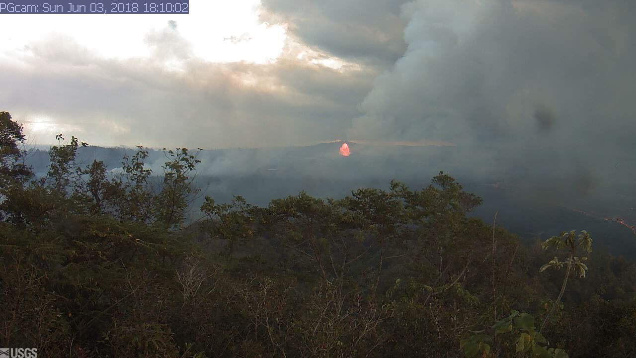
Kīlauea Volcano, East Rift Zone Live Panorama of Lower East Rift Zone Camera from Lower East Rift Zone [PGcam] Last Updated Sunday, June 3, 2018, at 6:10 p.m.
Due to lava crossing Highway 137 and approaching the ocean, the following policies are in effect:
There is no access to Kapoho and Vacationland as Highway 132 and Highway 137 is closed due to lava inundation.
Be aware of the laze hazard should lava hit the ocean and stay away from any ocean plume to prevent harmful health effects.
All areas abutting Highway 137 between Four Corners and Isaac Hale Park have been ordered to evacuate.
On roadways:
Government Beach Road, between Kahakai Boulevard and Papaya Farms Road, is open only to Waa Waa and Papaya Farms Road residents with official credentials. There is no curfew.
Sunday, June 2, 2018 at 1:15 p.m.
This animated GIF shows a sequence of radar amplitude images that were acquired by the Italian Space Agency’s Cosmo-SkyMed satellite system. The images illustrate changes to the caldera area of Kīlauea Volcano that occurred between May 5 and June 2 at 6 p.m.
The satellite transmits a radar signal at the surface and measures the strength of the return, with bright areas indicating a strong return and dark areas a weak return. Strong returns indicate rough surfaces or slopes that point back at the radar, while weak returns come from smooth surfaces or slopes angled away from the radar. Over time, expansion of the summit eruptive vent within Halema‘uma‘u crater and the widening of Halema‘uma‘u itself are clear. The last image in the sequence, from June 2, shows the development of several cracks outside Halema‘uma‘u (previously seen in UAS footage of the crater) and inward slumping of a large portion of the western crater rim. The west side of Halema‘uma‘u is clearly unstable, and it is possible that rockfalls and continued slumping will occur in the future.
Civil Defense Update:
Hawaiian Volcano Observatory reports active lava eruptions continue. Fissure 8, located in the Leilani Estates area, continues to feed a large channelized flow traveling downslope through Kapoho Beach Lots. The wide flow front is about 400 yards from the ocean.
Due to lava crossing Highway 137 and approaching the ocean, the following policies are in effect:
There is no access to Kapoho, Vacationland, Highway 132, and Highway 137.
First responders are conducting search and rescue missions in affected isolated areas today.
Be aware of the laze hazard should lava hit the ocean and stay away from any ocean plume to prevent harmful health effects.
On roadways:
Government Beach Road, between Kahakai Boulevard and Papaya Farms Road, is open to Waa Waa and Papaya Farms Road residents only with official credentials. There is no curfew.
Due to the volcanic activity, the following is provided for your information:
Volcanic gas and ash emissions remain high at the Kilauea summit and in the fissure system.
Pele’s hair and volcanic glass can be carried by the wind.
Residents on the south and west sides of the island should take action to limit exposure to gas, ash, and volcanic particles.
Stay alert to warnings from Civil Defense officials and be prepared to evacuate with little notice.
Sunday, June 2, 2018, at Noon.
Hawaiian Volcano Observatory reports that vigorous lava eruptions continue throughout the fissure system in the lower East Rift Zone. Fissure 8 continues to feed a large channelized flow that has crossed Government Beach Road and Highway 137. The flow is moving downslope toward the ocean through Kapoho Beach Lots. As of early this morning, the flow front was 500 yards from the ocean.
Due to lava crossing Highway 137, the following policies are in effect:
There is no access to Kapoho, Vacationland, Highway 132 and Highway 137.
First responders are actively conducting search and rescue missions in affected isolated areas today.
Contact Civil Defense if you confirm that someone you know is remaining in the isolated area. Call (808) 935-0031.
On roadways:
Government Beach Road, between Kahakai Boulevard and Papaya Farms Road, is open to Waa Waa and Papaya Farms Road residents only with official credentials. There is no curfew.
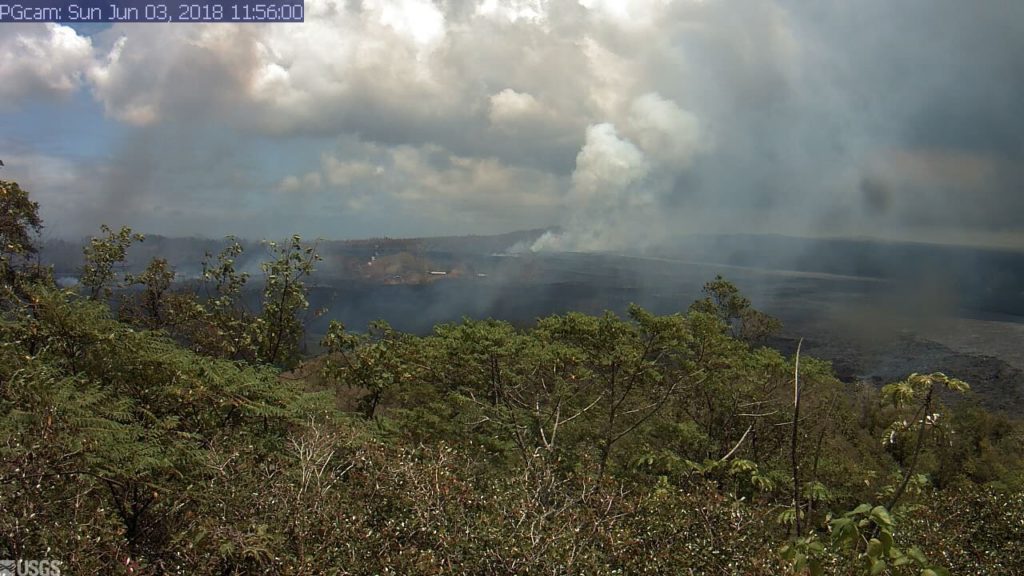
This image is from a temporary research camera positioned near Kapoho looking southwest. From left to right, one can see the eruptive fissures, with Fissure 15 on the far left, and Fissure 8 near the center. June 3, 2018 at 11:56 a.m.
Volcanic gas and ash emissions remain high at the Kilauea summit and in the fissure system. Residents in communities downwind, including Pahala, Ocean View, and Kona, should take action to limit exposure to gas and ash.
This thermal map shows the fissure system and lava flows as of 6:45 a.m. on Saturday, June 2. The flow from Fissure 8 continues to advance in a northeast direction and the front was roughly 6.3 miles from the vent at Fissure 8.
Click to enlarge
The black and white area is the extent of the thermal map. Temperature in the thermal image is displayed as gray-scale values, with the brightest pixels indicating the hottest areas. The thermal map was constructed by stitching many overlapping oblique thermal images collected by a handheld thermal camera during a helicopter overflight of the flow field. The base is a copyrighted color satellite image (used with permission) provided by Digital Globe.
U.S. Geological Survey:
Vigorous eruption of lava continues from the lower East Rift Zone (LERZ) fissure system in the area of Leilani Estates and Lanipuna Gardens.
Fissure 8 fountaining persisted throughout the night, and the channelized flow continued to deliver lava northeast along Highway 132 to the Kapoho area. Lava is advancing along a 0.5-mile-wide front towards the ocean at Kapoho Bay between Kapoho Beach Road and Kapoho Kai Drive. As of 7:30 a.m., the lava flow was about 430 yards from the ocean. Other branches of the Fissure 8 lava flow were inactive.
All other fissures are inactive, although Fissure 9 is steaming heavily.
Pele’s hair and other lightweight volcanic glass from high fountaining of Fissure 8 are falling downwind of the fissure and accumulating on the ground within Leilani Estates. Winds may waft lighter particles to greater distances. Residents are urged to minimize exposure to these volcanic particles, which can cause skin and eye irritation similar to volcanic ash.
Kīlauea Volcano Summit
Earthquake activity at the summit was high overnight, and it is possible that a small explosion, much like those that have occurred during the past two weeks, will take place in the next day. Ash emissions are low as revealed by webcam views this morning. Volcanic gas emissions at the summit remain high.
Hawaiian Volcano Observatory reports that vigorous lava eruptions continue throughout the lower East Rift Zone in Leilani Estates and Lanipuna Gardens.
Fissure 8 is feeding a large channelized flow traveling along Highway 132, the Pāhoa-Kapoho Road.
Lava has crossed Government Beach Road and Highway 137. The flow is moving downslope toward the ocean into Kapoho Beach Lots and as of early this morning, had reached Kapoho Kai Road to the south and as far east as Iliani Road
Due to lava crossing Highway 137, the following policies are in effect:
There is no access to Kapoho, Vacationland, Highway 132 and Highway 137.
Contact Civil Defense if you confirm that someone you know is remaining in the isolated area. Call (808) 935-0031.
On roadways:
Government Beach Road, between Kahakai Boulevard and Cinder Road, is open to Wa‘a Wa‘a and Papaya Farms Road residents only with official credentials. There is no curfew.
Volcanic gas emissions remain high at the Kīlauea summit and in the fissure system. Residents in communities downwind should take action to limit exposure to gas and ash. On the coast, be aware of laze from the ocean entry.
Stay alert to warnings from Civil Defense officials and be prepared to evacuate with little notice.
Shelters at Pāhoa Community Center and Kea’au Armory are open and pet-friendly.
This comments section is a public community forum for the purpose of free expression. Although Big Island Now encourages respectful communication only, some content may be considered offensive. Please view at your own discretion. View Comments