

Hurricane Lane Now Category 5
A Hurricane Watch is in effect for Maui County including the islands of Maui, Lana‘i, Moloka‘i and Kaho‘olawe and O‘ahu.
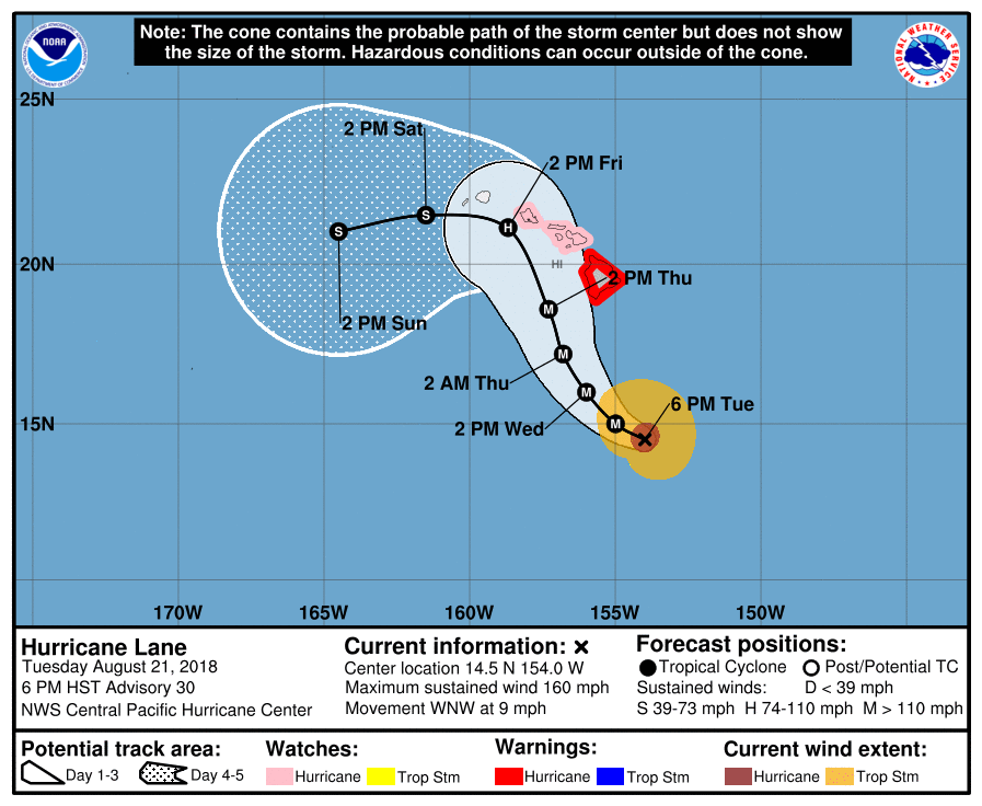
At 8 p.m the eye of Hurricane Lane was located by Air Force Reserve aircraft near latitude 14.5 North, longitude 154.1 West. Lane is moving toward the west-northwest near 9 mph (15 km/h) and this motion is expected to continue tonight. A turn toward the northwest is expected on Wednesday, followed by a turn to the north-northwest on Thursday. On the forecast track, the center of Lane will move very close to or over the main Hawaiian Islands from Thursday through Saturday.
Data from the aircraft indicate that maximum sustained winds have increased to near 160 mph (260 km/h) with higher gusts. Lane is now a category 5 hurricane on the Saffir-Simpson Hurricane Wind Scale.
Slow weakening is forecast during the next 48 hours, but Lane is forecast to remain a dangerous hurricane as it draws closer to the Hawaiian Islands.
Hurricane-force winds extend outward up to 40 miles (65 km) from the center and tropical-storm-force winds extend outward up to 140 miles (220 km).
The estimated minimum central pressure is 922 mb (27.23 inches).
Hazards affecting land:
WIND: Tropical storm conditions are expected within the Hurricane Warning area beginning late Wednesday night into early Thursday morning, with hurricane conditions expected somewhere within the warning area on Thursday. Tropical storm conditions are possible within the Hurricane Watch area beginning Thursday into Thursday night, with hurricane conditions possible late Thursday night into Friday.
RAINFALL: Excessive rainfall associated with Lane is expected to affect portions of the Hawaiian Islands from late Wednesday into the weekend, leading to flash flooding and landslides. Lane is expected to produce total rain accumulations of 10 to 15 inches with isolated amounts greater than 20 inches over the Hawaiian Islands.
SURF: Large swells generated by Lane will impact the Hawaiian Islands, beginning tonight on the Big Island, spreading across the remainder of the island chain on Wednesday. These swells will produce large and potentially damaging surf along exposed west, south and east facing shorelines.
Sponsored Content


