5 PM: Two More Structures Destroyed
This news story will be updated throughout the day as new information becomes available and new articles will be added to the website’s “News” section. Previous information about ongoing events can be found in Big Island Now’s “Volcano Blog” section.
KĪLAUEA SUMMIT LIVESTREAM LINK
CLICK HERE FOR INTERACTIVE LAVA MAP FOR JUNE 29, 2018
Friday, June 29, 5 p.m.: Two More Structures Destroyed
Hawaiian Volcano Observatory reports that Fissure 8 continues to be very active and is feeding a lava channel to the ocean at Kapoho.
The flow is producing a broad ocean entry along the shoreline, and is also oozing fresh lava at Kapoho Beach Lots. Gas emissions from the fissure eruption and laze at the ocean entry continue to be very high. The National Weather Service reports trade winds will reduce and VOG levels may increase in affected areas.
Due to the volcanic activity the following policies are in effect:
- Due to active lava near houses in Kapoho, access by residents is not allowed.
- Two structures have been destroyed in Kapoho in the past 24 hours.
- Due to frequent earthquakes, residents in the Volcano area are advised to monitor utility connections of gas, electricity, and water after earthquakes.
- Stay tuned to local radio stations for updates from Civil Defense.
Disaster assistance is available island-wide to individuals and businesses in Hawaii County that have been affected by the Kīlauea eruption.
- You can register for disaster assistance with Federal Emergency Management Agency (FEMA) in-person by visiting the Disaster Recovery Center, by calling (800) 621-3362, or online at disasterassistance.gov
- The Disaster Recovery Center is open daily from 8 a.m. to 8 p.m., and is located at the Kea‘au High School Gym. If you need a ride, buses operate between the two shelters and the Disaster Recovery Center between 7:30 a.m. and 9 p.m.
- For more resources to help you recover from this disaster, please visit the county website.
Friday, June 29, 10:30 a.m.: Lava Entering Sea Over Broad Area
The USGS Unoccupied Aircraft Systems (UAS) team conducted a flight on Kīlauea Volcano’s lower East Rift Zone to collect video in the upper lava channel of fissure 8. When it is dark the incandescence (glow) of lava is easy to see against the darkened surroundings.
Overnight UAS missions are the most efficient way for geologists to observe the lava channel to identify overflows and breaches of the channel. Scientists also use the video to assess lava flow velocities, which are measured by tracking surface features in the stationary video view. Using UAS for this type of investigation has many advantages because the aircraft can hover above hazardous areas and it utilizes stabilized gimbals and mounts so that the video captured by onboard HD cameras is steady and smooth. Information obtained from this mission was relayed to Hawai‘i County emergency officials to aid in issuing emergency alerts and notices about the timing of evacuations. Video by the U.S. Geological Survey and Office of Aviation Services, Department of the Interior, with support from the Hawaiian Volcano Observatory.
The eruption in the lower East Rift Zone (LERZ) continues with no significant change during the past 24 hours.
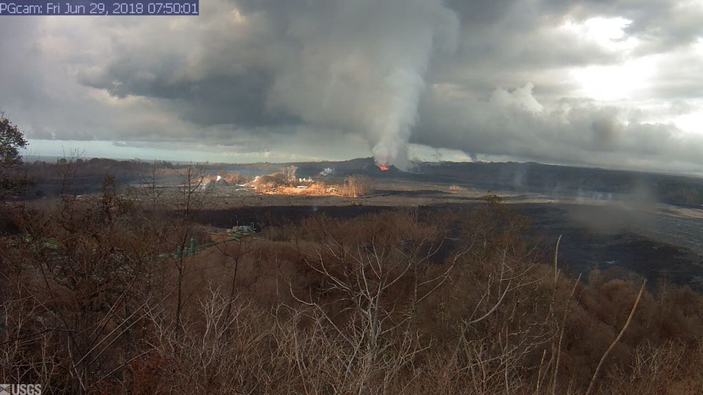
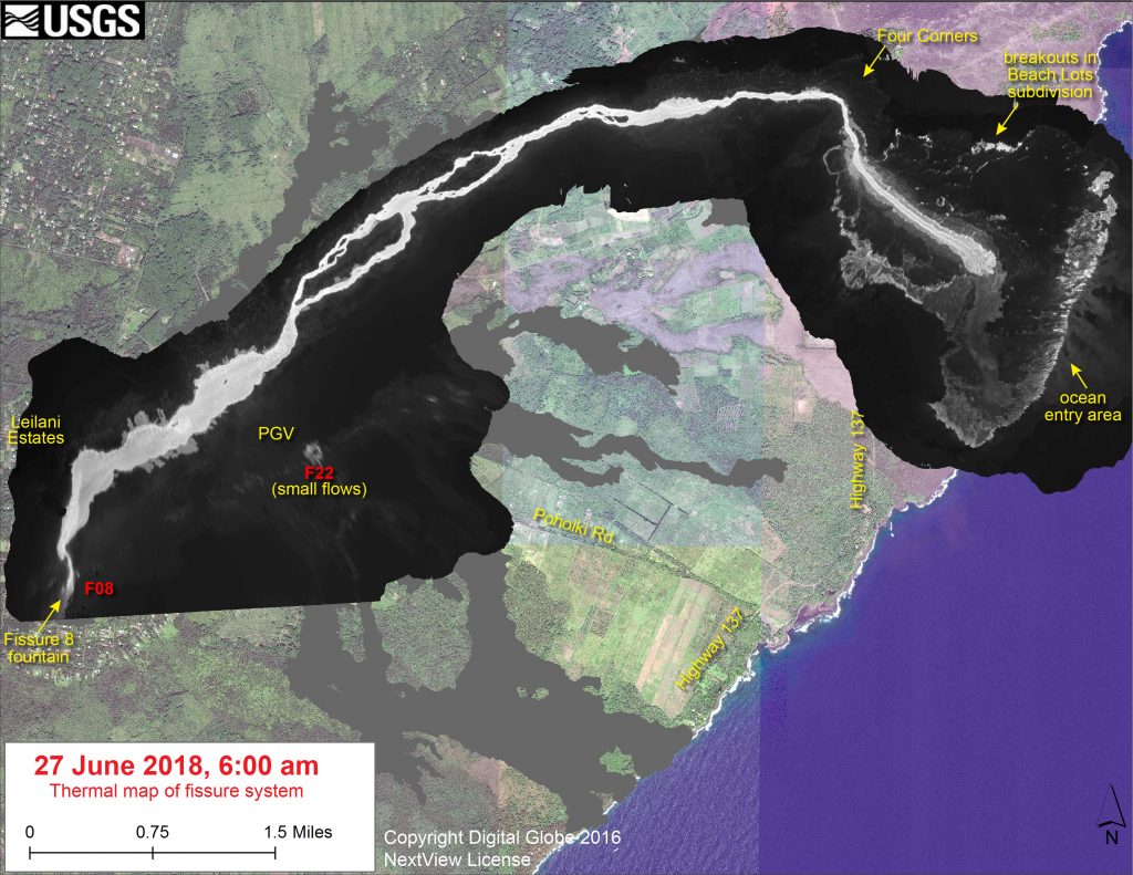
Fountains from Fissure 8 spatter cone continue to supply lava to the open channel with intermittent small, short-lived overflows. These overflows rarely extend beyond the existing flow field. No active overflows were observed during this morning’s helicopter overflight. The spatter cone is now about 180 feet tall at its highest point, and fountains rarely rise above that point. At the coast, the northern margin of the flow field is still oozing fresh lava at several points in the area of Kapoho Beach Lots and a few burning areas were observed on the south side of the flow and west of highway 137. Lava was entering the sea over a broad area this morning primarily on the northern side of the entry area. As shown by yesterday’s thermal map of the flow field, the lava channel has crusted over about 0.5 miles inland of the ocean entry; lava is moving beneath the crust and into still-molten interior of earlier flows before it enters the sea.
Pele’s hair and other lightweight volcanic glass fragments from the lava fountain at Fissure 8 continue to fall downwind of the fissure, dusting the ground within a few hundred yards of the vent. High winds may waft lighter particles to greater distances. Residents are urged to minimize exposure to these volcanic particles, which can cause skin and eye irritation similar to volcanic ash.
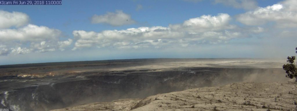
At 7:51 a.m., after approximately 15 hours of elevated seismicity, a collapse explosion occurred at the summit producing an ash-poor steam plume that rose about 500 feet above the ground surface (~4,500 feet above sea level) before drifting to the SW. The energy released by the event was equivalent to a magnitude 5.2 earthquake. Seismicity dropped abruptly from a high of 30-35 earthquakes per hour (many in the magnitude 2-3 range) prior to the collapse explosion down to 10 or fewer earthquakes per hour afterwards. Inward slumping of the rim and walls of Halemaʻumaʻu continues in response to ongoing subsidence at the summit.

This image is from a research camera mounted in the observation tower at the Hawaiian Volcano Observatory. The camera is looking SSE towards the active vent in Halemaʻumaʻu, 1.9 km (1.2 miles) from the webcam. Halemaʻumaʻu was approximately 1 km (0.6 mi) across and about 85 m (~280 ft) deep. The crater is now 1 X 1.3 km or 0.6 to 0.8 mi in dimension–the short dimension is in line with the camera view and the longer dimension is laterally from the camera view. The depth on June 15 was 370 m (1,210 ft). USGS Photo
Sulfur dioxide emissions from the volcano’s summit have dropped to levels that are about half those measured prior to the onset of the current episode of eruptive activity. This gas and minor amounts of ash are being transported downwind, with small bursts of ash and gas accompanying intermittent explosive activity.
Friday, June 29, 8 a.m.: Lava Near Houses in Kapoho
The Pacific Tsunami Warning Center has reported a gas explosion has occurred at 7:55 a.m at the Kīlauea Summit with an explosion equal to a 5.4 richter scale earthquake. There is No Tsunami Threat to Hawai‘i.
Ash plumes have been small but do take precautions if ash is detected in areas downwind of the summit.
Hawaiian Volcano Observatory reports that Fissure 8 continues to be very active and is feeding a lava channel to the ocean at Kapoho. The flow is producing a broad ocean entry along the shoreline, and is also oozing fresh lava at Kapoho Beach Lots. Gas emissions from the fissure eruption and laze at the ocean entry continue to be very high. The National Weather Service reports trade winds will push vog to the south and west side of the island.

Live Panorama of Lower East Rift Zone Camera from Lower East Rift Zone [PGcam]
Last Updated June 29, 2018, at 7:50 a.m. PC: USGS.
- Due to active lava near houses in Kapoho, access by residents is not allowed.
- Due to frequent earthquakes, residents in the Volcano area are advised to monitor utility connections of gas, electricity, and water after earthquakes.
- Under Emergency Provisions, any looting or vandalism during an emergency is treated as a felony.
- Law enforcement agencies are enforcing the Federal Aviation Administration’s Temporary Flight Restriction. No aircraft or drone activity is allowed within the Temporary Flight Restriction.
Disaster assistance is available island-wide to individuals and businesses in Hawai‘i County that have been affected by the Kīlauea eruption.
- The Disaster Recovery Center is open daily from 8 a.m. to 8 p.m., and is located at the Kea‘au High School Gym. If you need a ride, buses run between the two shelters and the Disaster Recovery Center.
- The Disaster Recovery Center is staffed with representatives from FEMA, the U.S. Small Business Administration, and State and County agencies.
- For more resources to help you recover from this disaster, please visit the Civil Defense website (http://www.hawaiicounty.gov/lava-related/)


