This news story will be updated throughout the day as new information becomes available and new articles will be added to the website’s “News” section. Previous information about ongoing events can be found in Big Island Now’s “Volcano Blog” section.
Saturday, May 26, 2018, at 7:15 p.m.: U.S. Geological Survey
Vigorous eruption of lava continues from the lower East Rift Zone fissure system in the area of Leilani Estates and Lanipuna Gardens. As of this morning, almost 2400 acres have been covered by new lava.
This image is from a temporary research camera positioned near Kapoho looking southwest. From left to right, one can see the eruptive fissures, with Fissure 15 on the far left, and Fissure 10 near the center. Panorama of Lower East Rift Zone Camera from Lower East Rift Zone [PGcam] Last Updated May 26, at 7:06 p.m.
Fissures 22, 6, and 13 are feeding lava flows moving southeast to the coast southwest of Pohoiki. At midday today, two ocean entries were active. Over the past 24 hours, channels feeding these ocean entries have diminished somewhat in vigor, however the laze plume generated remains significant.
Fissures 7 and 21 are feeding an ‘a’ā flow that has advanced to the northeast and this afternoon crossed Pahoa Pohoiki Road onto PGV property.
HVO field crews are on site tracking the fountains, lava flows, and spattering from multiple fissures as conditions allow and reporting information to Hawai‘i County Civil Defense. Crews are also checking on the status of ground cracks on Highway 130.
ARTICLE CONTINUES BELOW AD
ARTICLE CONTINUES BELOW AD
Volcanic gas emissions remain very high from the fissure eruptions. Trade winds are expected to diminish Sunday evening and the area impacted by vog could expand.
Magma continues to be supplied to the lower East Rift Zone. Earthquake locations have not moved farther downrift in the past few days and the number of located earthquakes remains low.
Ash continued to erupt intermittently from the Overlook crater at the Kīlauea summit. Observations from the ground and by UAV during the past week have documented retreat of the Overlook crater wall due to collapse of the steep enclosing walls and rim.
During the most energetic event of the day, ash from Overlook crater rose as 12-13,000 feet above sea level based on National Weather Service radar. Trade winds took the ash clouds primarily to the southwest. Trade winds are expected to diminish Sunday evening and communities around the summit area could see ashfall.
Earthquakes in the summit region continue as the summit area subsides and adjusts to the withdrawal of magma.
ARTICLE CONTINUES BELOW AD
Additional explosive events that could produce minor amounts of ashfall downwind are possible at any time. Volcanic gas emissions at the summit remain high.
Saturday, May 26, 2018, at 6 p.m.: Civil Defense
The Hawaiian Volcano Observatory reports the lava flow in Leilani Estates has crossed Pohoiki road slightly north of the HGPA site. The flows to the South continue to enter the ocean near MacKenzie State Park. Lava is now covering 2,372 acres, or 3.7 square miles.
Click to enlarge
Halema‘uma‘u crater is producing small bursts of volcanic ash. The ash is slowly being pushed downwind, southwest into the Ka‘ū District.
This image is from a research camera mounted in the observation tower at the Hawaiian Volcano Observatory. The camera is looking SSE towards the active vent in Halemaʻumaʻu, 1.9 km (1.2 miles) from the webcam. For scale, Halemaʻumaʻu is approximately 1 km (0.6 mi) across and about 85 m (~280 ft) deep. Photo taken Saturday, May 26, 2018 at 6 p.m.
Volcanic gases, vog and ash emissions may increase in areas down wind of the vents. Areas along Kamaili Road are experiencing elevated levels of sulfur dioxide.
ARTICLE CONTINUES BELOW AD
Saturday, May 26, 2018, at 11:30 a.m.: USGS Video:
Saturday, May 26, 2018, at 10:30 a.m.: Civil Defense
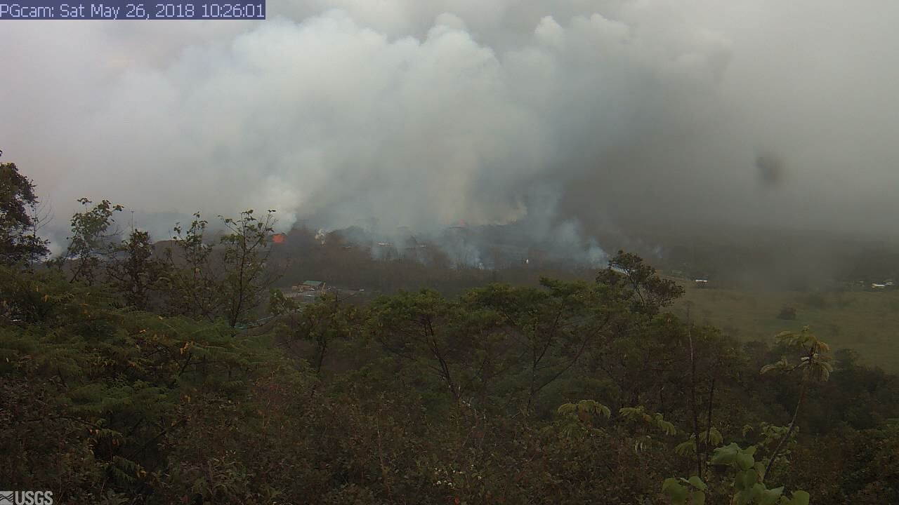
Live Panorama of Lower East Rift Zone Camera from Lower East Rift Zone [PGcam] Last Updated May 26, 2018, at 10:26
Lava flow activity continues in the East Rift Zone of Kīlauea. The flow in Leilani Estates has slowed its advance and is 150 yards from Pohoiki Road. The flows to the South continue to enter the ocean near MacKenzie State Park.
Due to the volcanic activity, the following policies are in effect:
Residents close to the active eruption must remain alert to changes in the flow direction and are advised to prepare for voluntary evacuation should their areas become threatened.
Areas along Kamalii Road are experiencing elevated levels of sulfur dioxide. Residents are advised to shelter in place or leave the area.
The Pāhoa Community Center, Kea‘au Community Center, and Sure Foundation Church are open. Food will be provided and the shelters are pet friendly.
Ash masks are being distributed at Cooper Center, Hawaiian Ocean View Community Center, Pahala Gym Annex, Shipman Gym in Kea‘au and Na‘alehu Nutrition Center from 9 a.m. to 1 p.m. today.
Saturday, May 26, 2018, at 9:00 a.m.: USGS Report
Eruption of lava continues in the area of Leilani Estates and Lanipuna Gardens.
Fissure 22 continues to erupt lava that is flowing southeast to the coast and the lava ocean entry. Fountains at Fissures 6 and 13 feed lava into a channel that reaches the coast forming a second ocean entry.
Fissures 7 and 21 are feeding a perched lava pond and pāhoehoe flow that has advanced northeastward covering most of the area between Kaupili and Mohala Streets. The flow front has become an ‘A’ā flow and is advancing slowly toward Pāhoa Pohoiki Road. The latest observations indicate the flow front is about 150 yards from the road. On the west side of Fissure 7 a perched pāhoehoe flow (near Makamae St) broke out around 4:00 a.m. feeding short flows to the west. Overnight, flaming and vigorous spatter was observed from a cone on Fissure 8, while Fissure 17 was the source of multiple booming gas emissions. Sensors in the LERZ indicated that the lava ocean entries remained active overnight.
HVO field crews are on site tracking the fountains, lava flows, and spattering from multiple fissures as conditions allow and reporting information to Hawai‘i County Civil Defense.
Volcanic gas emissions remain very high from the fissure eruptions.
Magma continues to be supplied to the lower East Rift Zone. Earthquake activity continues, but earthquake locations have not moved farther downrift in the past few days and the number of located earthquakes remains low.
Kīlauea Volcano Summit
There were three explosions from Overlook Crater (12:42 a.m., 1:44 a.m. and 5 a.m.) that produced ash clouds to between 10,000 and 11,000 feet above sea level. The National Weather Service Nexrad radar indicated that the clouds quickly dispersed. Several smaller explosions occurred over the course of the night. Moderate trade winds were blowing to the southwest and light ash fall likely occurred in downwind locations.
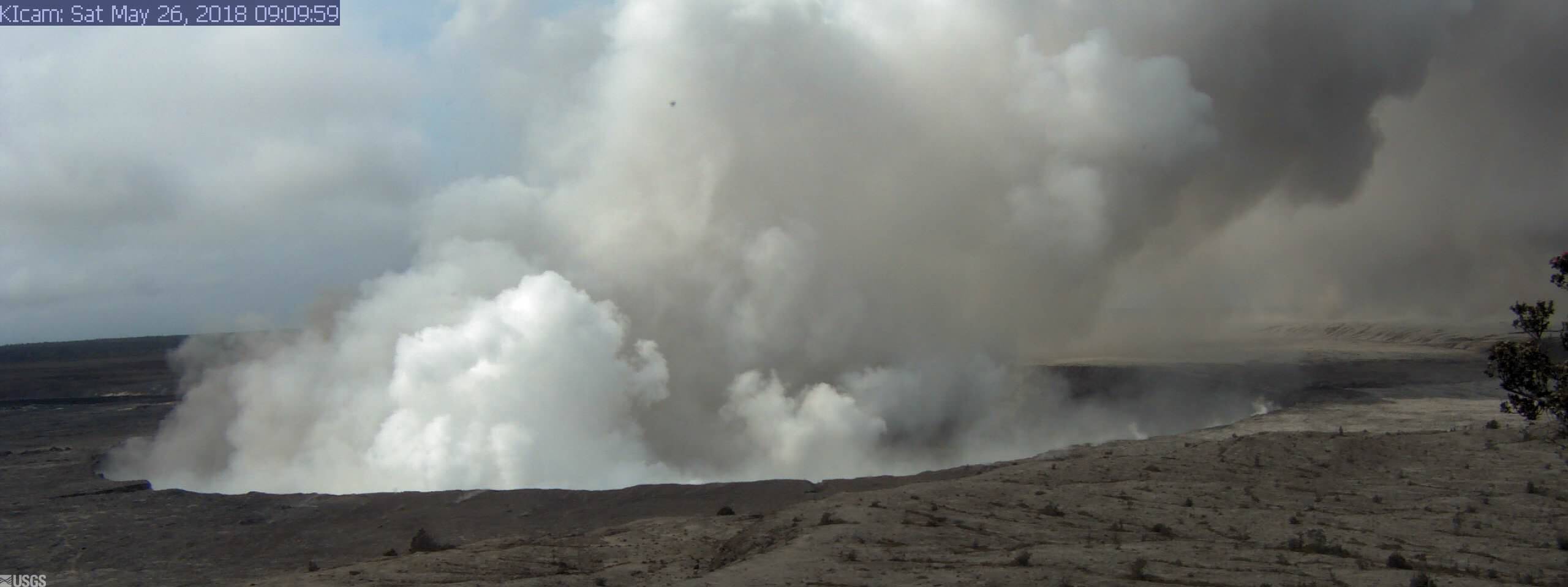
Live Panorama of Kīlauea Caldera from HVO Observation Tower Last Updated May 26, 2018 at 9:10 a.m.
Earthquakes in the summit region continued at a moderate rate overnight. The earthquakes and ash explosions are occurring as the summit area subsides and adjusts to the withdrawal of magma.
Additional explosive events that could produce minor amounts of ashfall downwind are possible at any time. Volcanic gas emissions at the summit remain high.
Original Post:
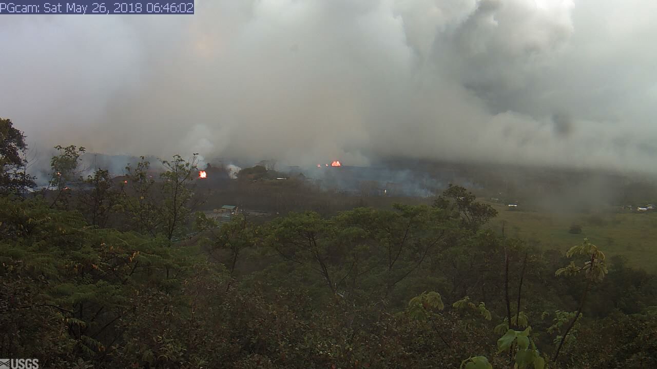
Panorama of Lower East Rift Zone Camera from Lower East Rift Zone Last Updated May 26, 2018 at 6:46 a.m.
The Hawaiian Volcano Observatory reports lava flow activity in the East Rift Zone of Kilauea. The flow in Leilani Estates has slowed its advance and is 150 yards from Pohoiki Road. The flows to the South continue to enter the ocean near MacKenzie State Park. There were two minor steam explosions at the Kilauea summit over the night. There is no immediate lava threat to PGV.
Due to the changing conditions, the following policies are in effect:
Take action to limit further exposure and be prepared to leave the area with little to no notice if necessary.
Ash fallout may cause poor driving conditions. Drive with extreme caution, or pull over and park.
Stay alert for warnings from Civil Defense officials.
To help our residents, we are distributing free masks for ash protection:
Distribution is today from 9 a.m. to 1 p.m. at Cooper Center, Hawaiian Ocean View Community Center, Pahala Gym Annex and Naalehu Nutrition Center.
Each person may receive up to three masks.
Masks do not protect against gasses and vapors. They will only provide filtering for ash.
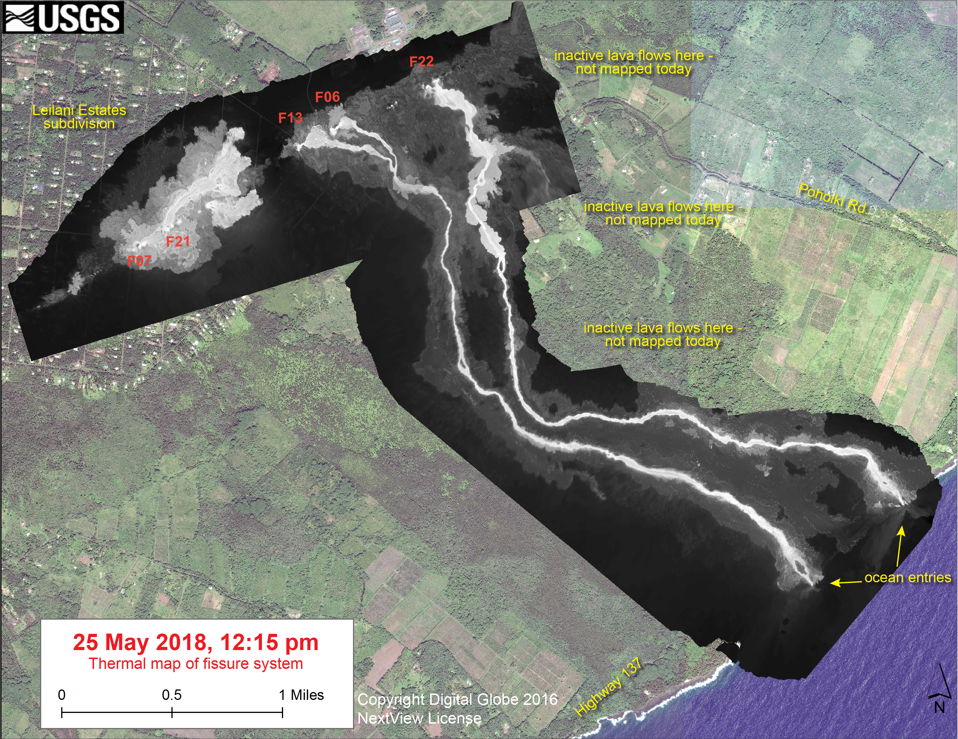
This thermal map shows the fissure system and lava flows as of 12:15 pm on Friday, May 25. Two channelized lava flows are reaching the ocean. In addition, a lava flow is active in Leilani Estates subdivision, near Fissure 7.
Click to enlarge
The region east of the lava channels includes a broad area of recent but inactive lava flows, and this area was not mapped today due to lack of change (see earlier maps for the extent of these flows). The black and white area is the extent of the thermal map. Temperature in the thermal image is displayed as gray-scale values, with the brightest pixels indicating the hottest areas. The thermal map was constructed by stitching many overlapping oblique thermal images collected by a handheld thermal camera during a helicopter overflight of the flow field. The base is a copyrighted color satellite image (used with permission) provided by Digital Globe.
This comments section is a public community forum for the purpose of free expression. Although Big Island Now encourages respectful communication only, some content may be considered offensive. Please view at your own discretion. View Comments