

5 PM UPDATE: Flash Flood Watch Extended to 8 PM

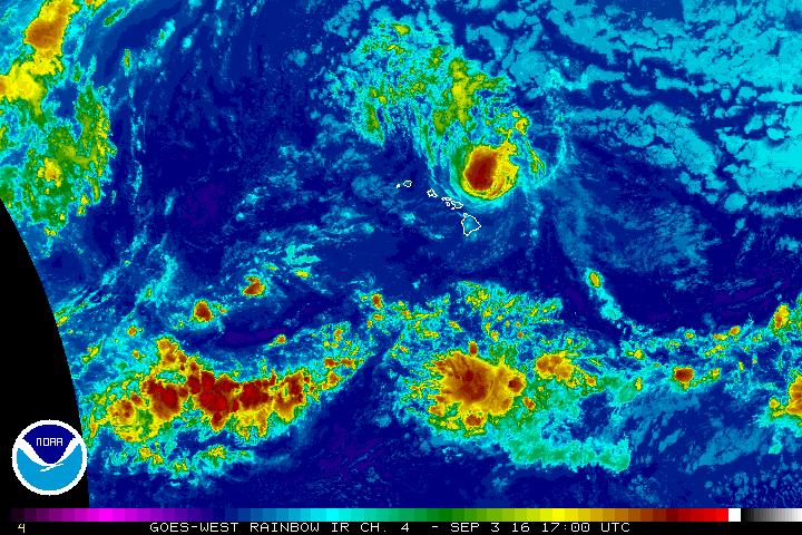
Hurricane Lester. Saturday, Sept. 3, 3:45 p.m.
Hurricane Lester, Saturday, Sept. 3, 7 a.m. NOAA/NWS

Hurricane Lester, Friday, Sept. 2, 6 p.m. NOAA/NWS

Hurricane Lester, Friday, Sept. 2, 12:30 p.m. NOAA/NWS

Hurricane Lester, Friday, Aug. 2, 5:30 a.m. NOAA/NWS

Hurricane Lester, Thursday, Sept. 1, 6 p.m. NOAA/NWS
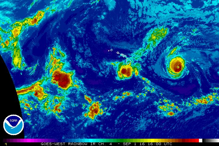
Hurricanes Madeline & Lester, Thursday Sept. 1, 2016, 6 a.m. NOAA/NWS
- Click here for Friday, Sept. 2, 5 p.m. video update with Malika Dudley
- Saturday, Sept. 3, 7:30 a.m.: Holiday Weekend Forecast for Big Island
- Saturday, Sept. 3, 10:10 a.m. Holiday Weekend Surf Report
- Click here for business and school reopenings
- Click here for emergency shelter information
- Click here for power, road and flooding status reports
- Click here for hurricane safety tips
- Click here for airline information
- Click here for Hurricane Madeline photos from across Hawai‘i County
UPDATE: Saturday, Sept. 3, 5 p.m.
The Flash Flood Warning remains in effect until 8 p.m. for Hawaii County.
At 5:39 p.m. emergency management reported heavy rain near mile marker 13 on Highway 190.
Rainfall was moving down slope near Pu‘uanahulu toward the Queen Ka‘ahumanu Highway.
Locations in the warning include but are not limited to Waikoloa Village, Puako, Pu‘uanahulu, Pohakuloa Training Area, Pohakuloa Camp, Waikii, Mauna Lani and Waikoloa Beach.
A Flash Flood Warning means that flooding in imminent or occurring in streams, roads and low-lying areas. Move to higher ground now.
Do not cross fast flowing water in your vehicle or on foot.
This warning may need to be extended beyond 8 p.m. if heavy rain
persists.
UPDATE: Saturday, Sept. 4, 4:30 p.m.
UPDATE: Saturday, Sept. 4, 3:45 p.m.
A Flood Advisory has been issued by the National Weather Service through 4:30 p.m.
Radar is indicating heavy rainfall continues over portions of the Hamakua and South Kohala Districts.
The heaviest rainfall was occurring along the Old Saddle Road near Waikiki and along the Mamalahoa Highway near the Waikoloa Junction.
Rainfall over Paulo and Honokaa areas seems to be diminishing.
As expected, light and variable wind conditions coupled with a lot of moisture in the atmosphere have led to flare ups of convective activity across parts of the Big Island.
As the land cools off and we get into cooler air temperatures, the threat for heavy rain and thunderstorms will begin to diminish.
If conditions persist, the advisory may be extended or upgraded to a warning.
UPDATE: Saturday, Sept. 4, 10 a.m.
At 8 a.m., the National Weather Service reported that Hurricane Lester was located 165 miles north-northeast of Hilo, moving west-northwest at 16 MPH with maximum sustained winds at 100 MPH with higher gusts.
The National Weather Service also reported that deep tropical moisture around Hurricane Lester will result in increasing showers with the possibility of localized heavier downpours or thunderstorms today through Sunday, Sept. 5.
A High Surf Warning for east facing shores remains in effect until 6 a.m. tomorrow morning. Surf heights in excess of 20 feet along east-facing shores have been reported.
The evacuation shelters at Pāhoa Community Center and at the Keaukaha-Kawananakoa Gym are now closed.
UPDATE: Saturday, Sept. 3, 4:56 a.m.
The National Weather Service’s high surf warning remains in effect until 6 a.m. Sunday, Sept. 4.
Expect surf 15 to 25 feet along all exposed eastern facing shores through tonight.
Surf will quickly begin to trend down along the exposed eastern shores on the Big Island by Saturday evening as Lester passes to the north.
Impacts are likely to be very high. Expect ocean water surging and sweeping across beaches, coastal benches and lava flows, creating the potential for impacts to coastal properties and infrastructure, including roadways.
Powerful longshore and rip currents will be present at most beaches.
Large breaking waves and strong currents may impact harbor entrances and channels causing challenging boat handling.
Large breaking surf, significant shorebreak and dangerous currents will make entering the water very hazardous.
Anyone entering the water could face significant injury or death.
UPDATE: Friday, Sept. 2, 6:30 p.m.
At 5 p.m., the National Weather Service reported that Hurricane Lester was located 270 miles east-northeast of Hilo, moving west-northwest at 14 MPH with maximum sustained winds at 105 MPH.
Hurricane Lester is expected to pass north of the Big Island early Saturday morning.
The National Weather Service has issued a High Surf Warning for east facing shores until 6 p.m. tomorrow evening.
Surf heights of 15 to 25 feet are expected for Big Island east-facing shores.
The public is advised to avoid east-facing shore areas.
For those who anticipate impact from high surf, shelters at Pahoa Community Center and Keaukaha – Kawananakoa Gym are open.
UPDATE: Friday, Sept. 2, 2:15 p.m.
At 2 p.m., the National Weather Service reported that Hurricane Lester was located 305 miles east of Hilo, moving west-northwest at 15 MPH with maximum sustained winds of 105 MPH.
Hurricane Lester is expected to pass north of the Big Island early Saturday morning.
In addition, the National Weather Service forecasts that surf heights of 15 to 25 feet are expected for Big Island east-facing shores.
A High Surf Advisory for east facing shores of the Big Island remains in effect until 6 p.m. this evening.
A High Surf Warning will be in effect for east facing shores from 6 p.m. this evening until 6 p.m. Saturday evening.
For those who anticipate impact from high surf, shelters will open at 5 p.m. today at Pahoa Community Center and at Keaukaha – Kawananakoa Gym.
UPDATE: Friday, Sept. 2, noon
The Coast Guard urges mariners and beachgoers to exercise extreme caution with the arrival of Hurricane Lester over Labor Day weekend.
Residents and visitors throughout the state should heed all warnings from lifeguards and public health and safety officials.
Hurricane Lester is expected to generate extremely dangerous offshore sea conditions with maximum wave heights of 35 feet and winds in excess of 74 mph.
In the coastal environment, high surf exceeding 20 feet is expected to impact beaches creating dangerous currents and rip tides.
Even the best swimmers can fall victim to strong storm-generated waves and currents. Swimmers are urged to stay clear of beaches until local officials say the water is safe.
Near-shore waters may become contaminated due to runoff up to several days following a storm.
Mariners should secure their boats and boating equipment. Owners of large boats are urged to move their vessels to protected marinas where they will be less likely to break free of their moorings or to be otherwise damaged. Smaller boats should be pulled from the water and stored in a place that is not prone to flooding and is protected for high winds. Regardless of location, all loose items aboard vessels should be secured or removed.
Currently, all commercial ports are open throughout the main Hawaiian Islands.
There are no anticipated port closures at this time; however, port closures are subject to change depending on the path of the storm.
The Coast Guard will continue to broadcast Notice to Mariners and post Marine Safety Information Bulletins online to notify the future closing of ports and any special conditions.
A PDF version of the Hawai’i Boater’s Hurricane and Tsunami Safety Manual can be found here.
For more information on hurricane preparedness, visit the National Hurricane Center online.
UPDATE: Friday, Sept. 2, 6:28 a.m.
The Hurricane Watch for the Island of Hawai‘i has been cancelled as Hurricane Lester continues on a west-northwest path.
As of 5 a.m., Hurricane Lester was located 435 miles east of Hilo, moving west-northwest at 14 MPH with maximum sustained winds at 110 MPH. Lester is expected to pass north of the Big Island early Saturday morning.
The National Weather Service has issued a High Surf Warning for North and East facing shores of the Island of Hawaii in effect until 6 p.m. this evening, Friday, Sept. 2.
A high surf warning will be in effect from 6 p.m. Friday evening to 6 p.m. Saturday.
Surf 6 to 10 feet will rise to 10 to 18 feet late this afternoon.
Surf will rise to 15 to 25 feet tonight along east facing shores of The Big Island. This warning-level surf will continue through Saturday.
Expect very high Impacts—ocean water surging and sweeping across beaches, coastal benches and lava flows, creating the potential for impacts to coastal properties and infrastructure, including roadways.
Powerful longshore and rip currents will be present at most beaches. Large breaking waves and strong currents may impact harbor entrances and channels causing challenging boat handling.
Large breaking surf, significant shorebreak and dangerous currents make entering the water very hazardous. Anyone entering the water could face significant injury or death.
People are also advised to avoid forested areas due to potential for rising streams, flash flooding and falling trees.
UPDATE: Thursday, Sept. 1, 6 p.m.
A Hurricane Watch remains in effect for Hawai‘i County.
At 5 p.m. today, the National Weather Service reported Hurricane Lester was 595 miles east of Hilo, moving west-northwest at 14 miles per hour with maximum sustained winds of 125 miles per hour.
All county and state facilities, offices and services have returned to a normal schedule. All DOE public and Charter schools will be in session Friday, Sept. 2. Private school families are encouraged to check with their schools for more information.
The public is advised to be storm ready.
Tropical storm readiness tips and information are available on the Civil Defense message page at hawaiicounty.gov.
UDDATE: Thursday, Sept. 1, 5:30 a.m.
Hawai‘i Island and Maui are under a Hurricane Watch, and according to the National Weather Service as of 11 a.m., the center of Hurricane Lester was 675 miles east of Hilo, moving west at 13 mph. Forecasters are again expecting very heavy rainfall, dangerously high surf and hurricane-force winds.
UPDATE: Thursday, Sept. 1, 5:30 a.m.
This is a Tropical Storm Madeline and Hurricane Lester update for Thursday, Sept. 1 at 5:30 a.m.
The National Weather Service has cancelled the Tropical Storm Warning for Madeline as it has passed to the south of Hawai‘i Island.
County and state facilities, offices and services will resume today including Hele-On Bus service and solid waste transfer stations. Parks will reopen pending damage assessments. All roads have reopened.
Damage Assessment teams will be out in targeted areas today. If your home or business has been damaged, call Civil Defense at 935-0031.
In anticipation of Hurricane Lester, the National Weather Service has issued a Hurricane Watch for Hawai‘i County.
As of 5 a.m., Lester is about 750 miles east of Hilo moving west at 14 miles per hour with maximum sustained winds of 105 miles per hour. High surf is expected to begin building today on east facing shores. Heavy rains and winds from Lester are possible on Saturday.
Sponsored Content


