Kilauea Summit Update – 5/22/15
Another week of activity is coming to a close at Kilauea’s summit. The week of May 18 has proved to be one of settling down and leveling out.
Hawaiian Volcano Observatory reports normal background level seismic activity below the summit of Kilauea, upper East Rift Zone, and Southwest Rift Zone. This return to normal activity began on Tuesday after weeks of increased seismicity and summit activity.
Inflationary tilt was noted by the observatory over the past day at the summit. HVO officials say tiltmeters recorded inflationary tilt from Halema’uma’u just after midnight.
No significant tilt at the north flank of Puʻu ʻŌʻō or heightened seismic activity in the area has been reported by HVO. Activity in the Puʻu ʻŌʻō area has remained relatively level over the past week.
HVO scientists continue to monitor the June 27 lava flow through webcam and satellite imagery. The images show continued activity from several breakouts, all of which are in the northeast area of Puʻu ʻŌʻō and within 5 miles of Puʻu ʻŌʻō.

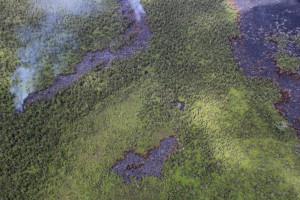
The most distant active tip of the June 27 flow, visible at the left edge of the photo, was about 8.5 km (5.3 miles) from Puʻu ʻŌʻō on May 21. This lobe of the flow intersected an old lava tube earlier in the week that transported lava a short distance downslope, where it emerged from skylights to make several small isolated pads of lava (center of the photo). The view is to the southwest, so Puʻu ʻŌʻō is well off in the distance beyond the top of the photo. USGS/HVO photo.


