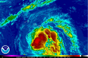
11 P.M. UPDATE: Ana Strengthens, Tropical Storm Conditions Unlikely
The Central Pacific Hurricane Center has just released their 11 p.m. update on Hurricane Ana. A Flash Flood Advisory is posted for the island of Hawai’i. The intensity of the storm has increased a bit since the last update and the track still brings Ana south of the islands through the forecast period. The chance of tropical storm conditions has greatly diminished and hurricane conditions are not likely. The center of Ana is 205 miles southwest of Hilo, 160 miles southwest of Kailua-Kona, and 135 miles southwest of South Point.
Summary of Alerts
FLASH FLOOD ADVISORY – Posted for Island of Hawai’i through 1:30 a.m.
HURRICANE WARNING – In effect for all Hawaiian offshore waters.
TROPICAL STORM WARNING – Still listed for all Hawaiian opffshore waters, Big Island leeward coastal waters, and Big Island southeast waters.
TROPICAL STORM WATCH – Remains in effect throughout the state, including all coastal waters.
Current Situation
Ana is still a Category 1 hurricane with 85 mph maximum sustained winds, gusting to 104 mph. The system is moving northwest at 13 mph. Hurricane force winds extend outward 25 miles from the center, and tropical storm force winds extend 115 miles.
A decrease in forward speed is expected Saturday night and Sunday with a turn toward the west. If the track does not change, ana is expected to pass 150 miles southwest of the Big Island tonight and 175 miles southwest of the rest of the islands over the weekend. Ana is expected to maintain hurricane status through Saturday and slowly weaken Sunday.
Impacts to the Big Island
At 10:30 p.m., heavy rain was falling in lower Kohala and along north Kona slopes.
At 9:15 p.m., heavy rain was falling near Kapapala Ranch and Wood Valley at a rate of 2 – 3 inches per hour. Outer rain bands of Ana are reaching the Ka’u and Puna district slopes. Rainfall is expected to continue to move onshore for several hours. The heaviest rainfall has been observed from Volcano to Pahala.
Radar at 8:30 p.m. was showing the outer rainbands and thunderstorms from Hurricane Ana lashing parts of the Big Island, mainly the southern parts of the Ka’u and Kona districts, as well as the southern and western coastal waters surrounding the Big Island. Additional heavy showers and thunderstorms are likely to continue overnight as Ana gradually moves away from the Big Island. Strong wind gusts to tropical storm force are expected in the heavier showers and storms overnight.
Potential future impacts to the Big Island:
Chance of tropical storm conditions is 7 percent for South Point, 8 percent for Kailua-Kona, and 5 percent for Hilo. This is a distinct downward trend since the last forecast.
Winds: Kau and South Kona may get winds from 25 to 35 mph, gusting to 50 mph tonight. Higher elevations of the Big Island could see wind numbers from 40 – 50 mph, gusting to 60 mph.
Rain: Rainfall rates of 4 to 6 inches, possibly up to a foot of rain along southeast facing slopes, are expected.
Surf: Hawai’i County Civil Defense reports surf of 10 to 15 is already occurring near South Point. The surf is expected to peak tonight and Saturday morning at 20 feet along the Puna and Ka’u coastlines during the closest approach. Elevated surf up to 12 ft is possible along the Kona coast on Saturday.
Seas: Leeward waters of the Big Island can expect 35 – 45 mph winds, gusting to 65 mph with seas up to 25 feet. Off Cape Kumukahi, winds are expected from 20 – 30 mph with seas of 15 – 20 feet.


