


Severe weather Wednesday update: Hurricane or tropical storm watch likely to be required for part of state by early Thursday
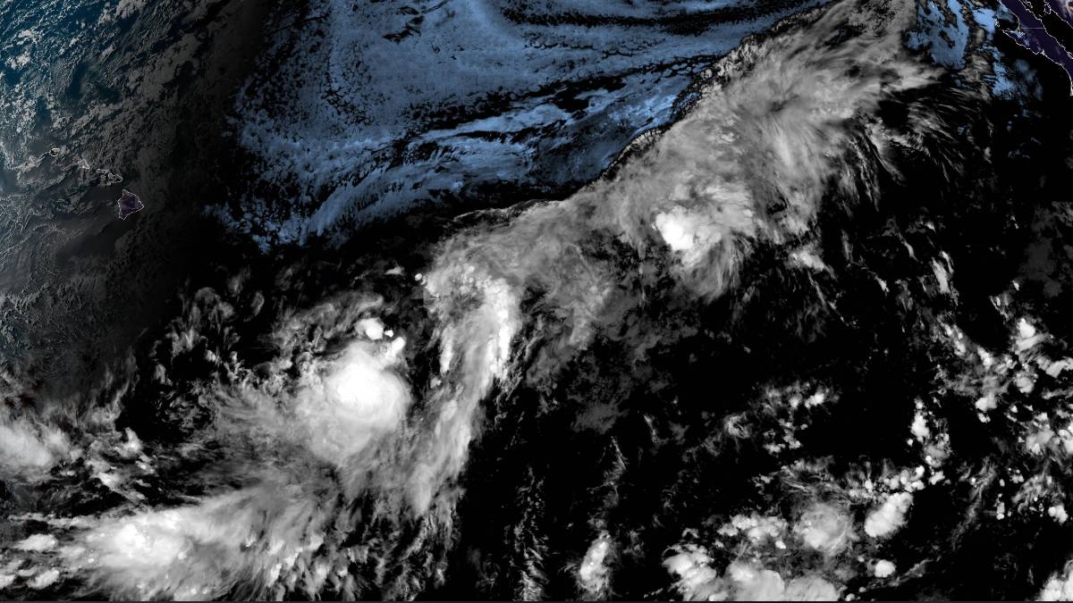
National Hurricane Center reports Potential Tropical Cyclone One-C remains about 900 miles east-southeast of Hilo and now has sustained winds of nearly 40 mph as it continues moving about 9 mph toward Hawaiʻi, according to a Hawaiʻi County Civil Defense message early the evening of Aug. 12.
This story was updated at 6:43 p.m. Aug. 12, 2026.
National Hurricane Center reports Potential Tropical Cyclone One-C remains about 900 miles east-southeast of Hilo and now has sustained winds of nearly 40 mph as it continues moving about 9 mph toward Hawaiʻi, according to a Hawaiʻi County Civil Defense message early the evening of Aug. 12.
The system is forecast to develop into a tropical storm by Aug. 13.
Civil Defense urges all residents to prepare for possible impacts of high surf, flooding rains and damaging winds by reviewing their emergency plan; making sure they have food, water and fuel; and signing up for Civil Defense alert messages.
Visit the Hawaiʻi County Hazard Impact Map for information about all hazards impacting the island along with any watches, warnings or other weather-related information.
National Hurricane Center and Central Pacific Hurricane Center report in their 5 p.m. Wednesday update that the center of the system now known as Potential Tropical Cyclone One-C will near the Hawaiian Islands by late Aug. 14.
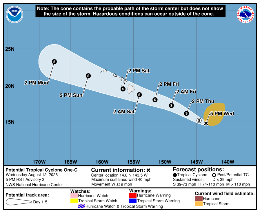
While maximum sustained winds are near 40 mph as Civil Defense reported, with higher gusts, the system still lacks organized shower and thunderstorm activity. It is nonetheless still forecast to become a tropical storm Thursday, with additional strengthening thereafter.
Tropical storm force winds extended up to 275 miles outward from the system’s center.
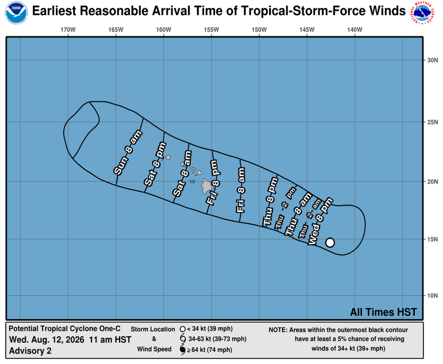
A hurricane or tropical storm watch will likely be required for a portion of the state by early Thursday.
There is an increasing risk of wind impacts regardless of the exact track of the system. It also is expected to produce rainfall totals of 5 to 10 inches across much of the island chain, with maximum totals of 20 inches possible in some locations.
That rainfall could produce life-threatening flooding and mudslides, especially in areas of steep terrain.
Swells generated by the disturbance are expected to reach east-facing shores of the state Friday, spreading westward and building through the weekend. These swells are likely to cause life-threatening surf and rip current conditions.
The disorganized system of showers and thunderstorm activity is expected to become a tropical storm within the next day, and forecasters list a 90% chance it will develop into a tropical cyclone within the next 2 days.
Location or magnitude of potential impacts remain 100% uncertain; however, the storm is closer to Hawai‘i than cyclones typically are, meaning impacts could occur with less warning than usual.
“We are closely tracking the development of this storm system and actively preparing for any hazards that could affect our island,” said Hawaiʻi County Mayor Kimo Alameda in a county release. “While the magnitude of impacts is uncertain at this time, the best way to keep you and your family safe is to prepare now and stay connected. Take the time to check on your home and follow official county channels, including our emergency alerts, and local news sources for updates.”
County officials urge the public to prepare for the possibility of severe — and even damaging — weather. Development of a tropical cyclone — which includes tropical depressions, tropical storms and hurricanes — could cause significant hazards as early as the evening of Aug. 14, including strong and high wind as well as heavy rainfall.
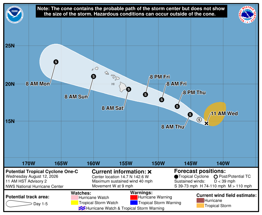
“While a tropical cyclone has not yet formed, environmental conditions are conducive for further development, and a tropical depression or storm is expected to form on Wednesday,” said information from the National Weather Service in Honolulu. “The disturbance is expected to move generally northwestward across the Central Pacific and toward the vicinity of the Hawaiian Islands later this week and into the weekend.”
Residents can limit damage and keep themselves safe by taking the following steps:
- Make a plan for how to shelter at home or move to safe shelter before a storm arrives. Discuss it with your family.
- Check around your home and trim vegetation that could be downed by wind and cause damage. Secure objects that could become airborne.
- Clear any debris that can block water from freely draining.
- Be ready for power outages.
- Make sure you have emergency food, water and medication for everyone in your household (including pets).
- Sign up online for Hawaiʻi County Civil Defense emergency alerts.
“Interests in the Hawaiian Islands should closely monitor the progress of this system,” said the update.
Forecasters joined the county in urging the public not to wait when it comes to making preparations.
“Prepare now,” the National Weather Service said early Wednesday morning. “Residents and visitors should continue to monitor the latest forecasts during the coming days and use this time to review hurricane preparedness plans and supplies. Do not focus on any single model forecast or projected track while the system remains in its early stages of development.”
Concerns for fire weather also increase Friday as winds begin to strengthen and a dry and stable air mass with low relative humidity in advance of the storm will likely lead to high wildfire potential.
Hawaiian Electric is also advising customers to review emergency plans to ensure they have supplies they need on hand and to closely monitor weather updates. Preparation and safety tips are available at hawaiianelectric.com/stormcenter.
In preparation for severe weather, the power company is conducting training to prepare employees to respond safely and as quickly as possible to storms and other emergencies. There will also be outreach conducted with federal, state and local agencies to ensure coordination of response efforts.








