


What HVO Geologists Learned From Kīlauea’s 2018 Eruption
May 3, 2019, marks the one-year anniversary of the start of Kīlauea Volcano’s 2018 lower East Rift Zone eruption. Over the past year, USGS Hawaiian Volcano Observatory (HVO) geologists and collaborators have been closely studying the vast amount of data collected during the summer eruption. Now is a good time to explore what’s been learned, and what’s still unfolding.
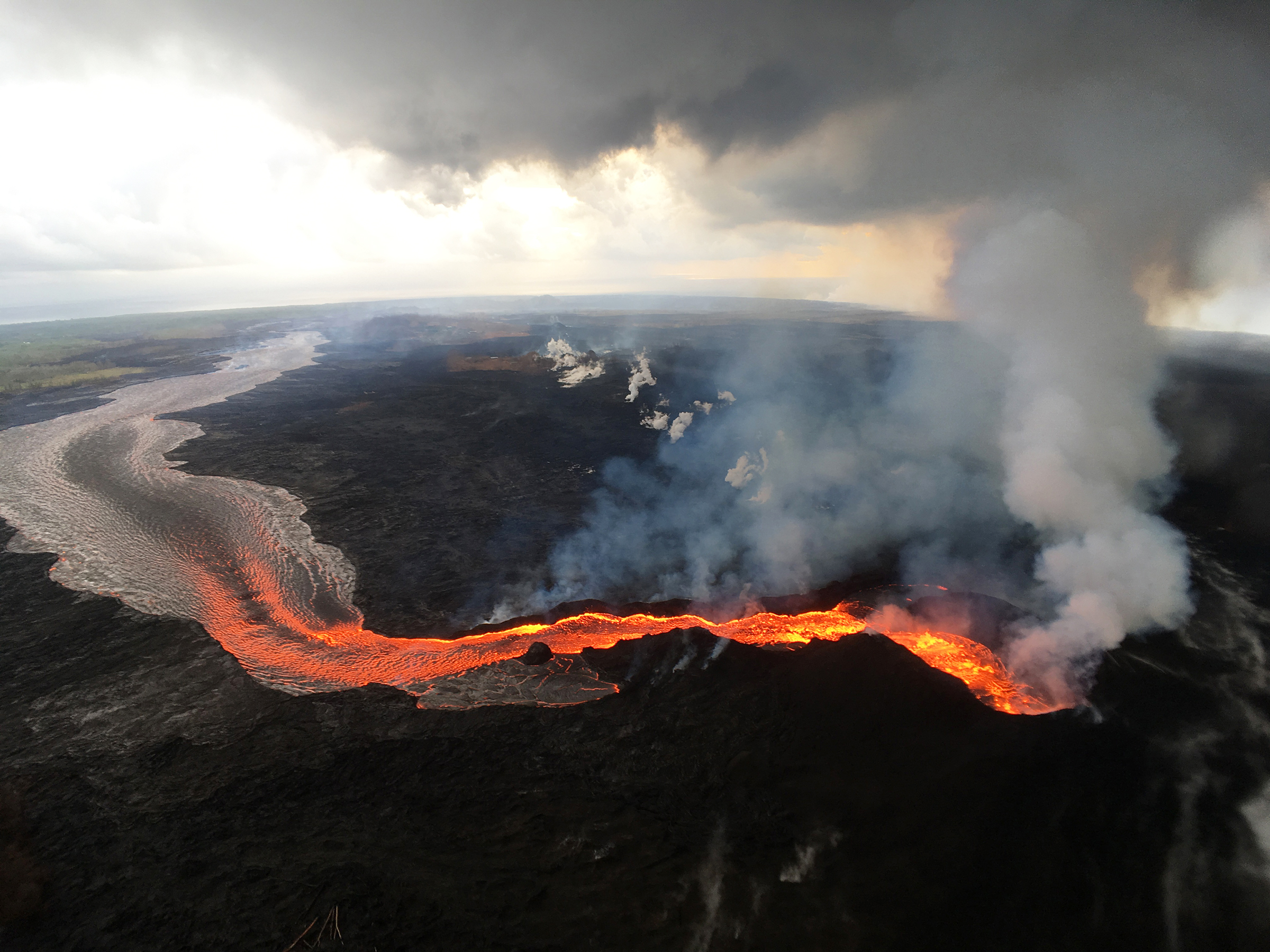
During the first two weeks of Kīlauea Volcano’s 2018 lower East Rift Zone eruption, fissures were characterized by low eruption rates and small flows. This was because the erupted lava originated from pockets of cooler, less fluid magma stored in the rift zone. Later fissures erupted hotter, more fluid magma, resulting in higher eruption rates and large, fast-moving lava flows, like that erupted from the fissure 8 cone (lower right), shown here on July 29, 2018. PC: USGS photo by M. Patrick.
The lower East Rift Zone eruption, as well as the 2018 summit collapses, are providing many new insights on Kīlauea. This week’s Volcano Watch focuses on a few aspects of the lower East Rift Zone eruption that are helping us better understand volcanic hazards in Hawai‘i.
First, ongoing work is telling us how the changing chemical composition of the magma erupted in 2018 controlled the lava-flow hazard. The first two weeks of the eruption (May 3–18) produced low eruption rates and relatively small flows. Chemical analyses indicated that the lava originated from pockets of older magma stored underground in the lower East Rift Zone. This cooler and less fluid magma was probably residue from earlier eruptions.
This stored magma was presumably forced out by the intruding dike of magma that originated from Pu‘u ‘Ō‘ō. University of Hawai‘i at Hilo researcher Cheryl Gansecki says that chemical analyses indicate that the dike may have intersected two, or even three, separate stored magma bodies.
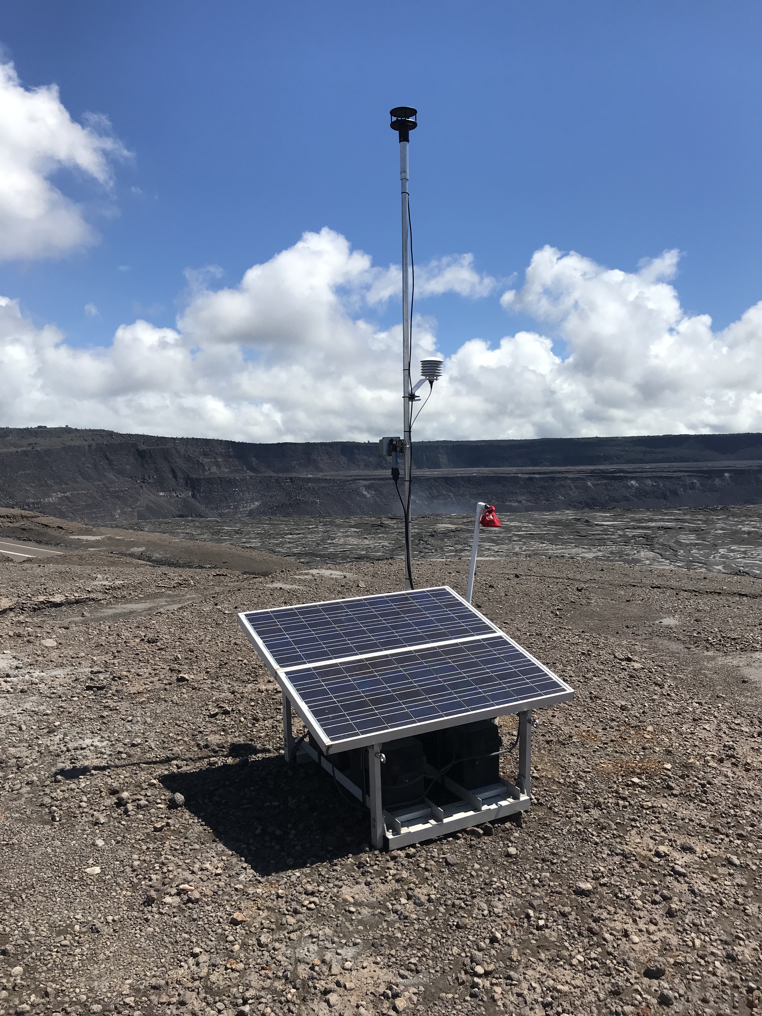
Hawaiian Volcano Observatory field crews establish a new MultiGAS volcanic gas monitoring station at the summit of Kīlauea Volcano. Currently, sulfur dioxide emission rates from the summit remain low. The station will collect data to track emission rates and concentrations over time. PC: USGS photo by F. Younger.
Around May 18–19, the eruption vigor changed as hotter and more fluid magma was erupted. This magma was presumably draining from the summit magma reservoir. The eruption rate increased roughly 10-20 times, and the flows became larger, faster-moving, and much more hazardous.
A similar—although less dramatic—chemical change occurred during the 1955 lower East Rift Zone eruption, but it was not recognized until long after that eruption ended. Daily tracking of lava composition during the 2018 eruption was important because it allowed us to identify the chemical change pattern in early May, and to correctly anticipate that hotter, more fluid magma—and more hazardous lava flows—might be around the corner.
Taken together, the 2018 and 1955 eruptions point to the possibility that future rift zone eruptions can start deceptively small in the opening days as older, stored magma is erupted. But once the magma “spigot” is opened, and fresher, hotter magma arrives, rift zone eruptions can switch to large, fast-moving, and hazardous lava flows.
Magma composition also helped explain another hazard of the 2018 eruption. In mid-May, brief explosions occurred frequently from Fissure 17, throwing lava bombs several hundred meters (a few hundred yards). An initial explanation was that they were driven by groundwater seeping into the fissures, causing steam blasts.
However, chemical analyses revealed that fissure 17 erupted lava with an unusual composition. Nearly all lava erupted on Kīlauea is basalt, but fissure 17 erupted Kīlauea’s first documented andesite. Andesite is higher in silica than basalt, and is, therefore, less fluid. The more viscous consistency of andesitic lava makes it easier for large gas bubbles to coalesce and burst with high pressure, which provides a likely explanation for the explosive activity at fissure 17.
The eruption also highlighted the close connection between Kīlauea’s East Rift Zone and the volcano’s summit magma reservoir. In June and July 2018, there were near-daily summit collapse events, each with the equivalent of a magnitude-5.3 earthquake.
Time-lapse cameras monitoring the Fissure 8 lava channel observed that the eruption rate began to increase within minutes after a summit collapse, eventually peaking 2–4 hours later. At least once, the increased eruption rates produced overflows from the lava channel that could have threatened adjacent residential areas.
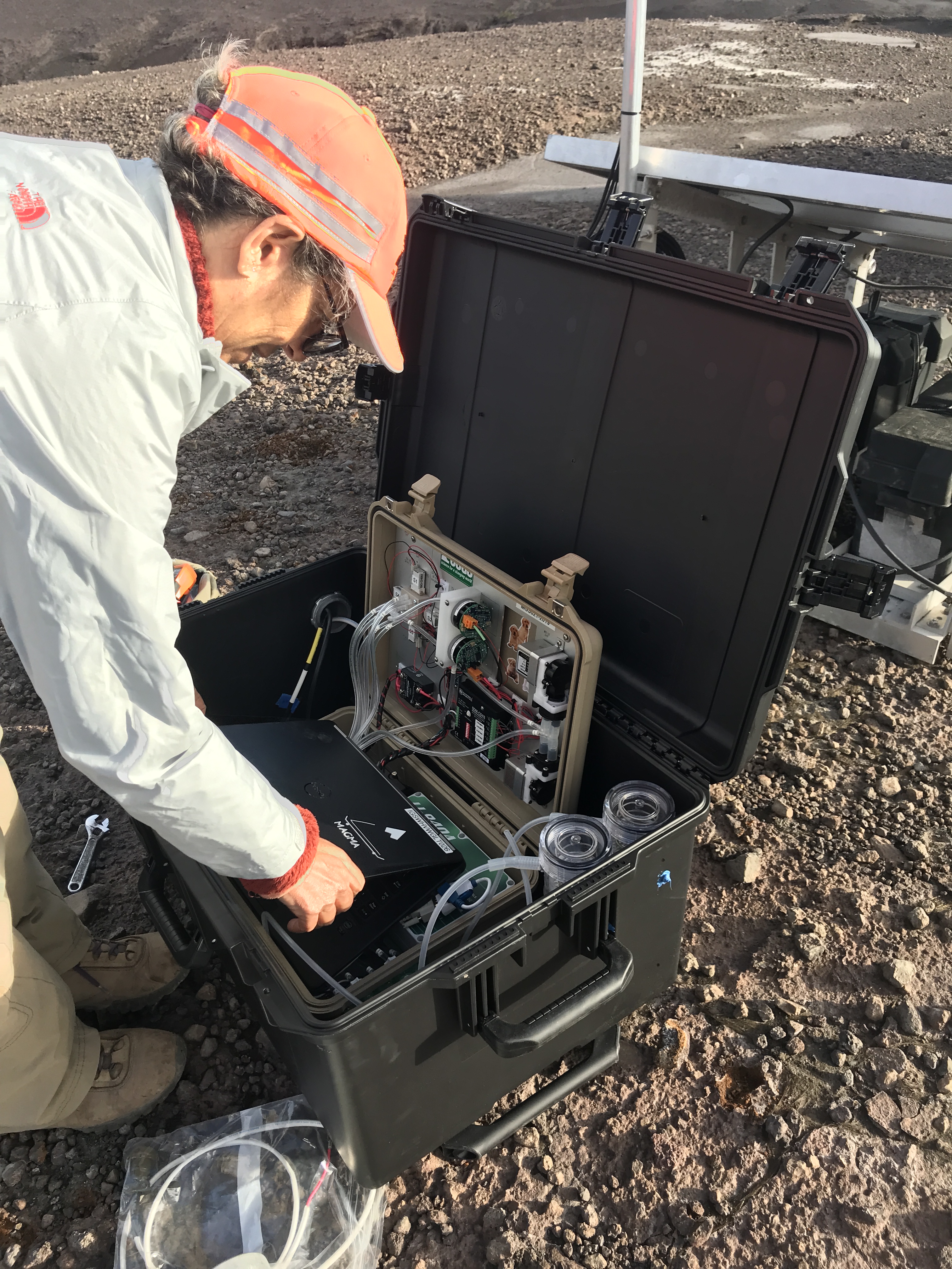
A close-up of the MultiGAS instrument (in tan box), which is placed inside a larger black box to protect the instrument from the weather. The MultiGAS instrument collects an air sample and measures the concentrations of volcanic gases such as sulfur dioxide and carbon dioxide, as well as collecting data on environmental parameters like temperature and pressure. The collected data is transmitted by radio to HVO, providing a record of changes in gas concentration that helps in understanding magma depth and the pathways by which gas reaches the surface. PC: USGS photo by F. Younger.
The short delay before lower East Rift Zone eruption rates increased indicates that the “surge” in eruption vigor was driven by a pressure pulse originating from the summit collapse and transmitted down the 40-km- (25-mi-) long magma conduit to the lower East Rift Zone—akin to a hydraulic press. The 2–4-hour delay in peak eruption rates allowed HVO and emergency managers, in at least one instance, to anticipate and prepare for the overflow hazard.
These are just a few of the new insights gained from Kīlauea’s 2018 lower East Rift Zone eruption. They show how unraveling each volcanic process helps us better understand the hazard, and, in turn, to forecast and prepare for hazards in future eruptions.
Volcano Activity Update
Kīlauea Volcano is not erupting and its USGS Volcano Alert level remains at NORMAL.
Rates of seismicity, deformation, and gas release have not changed significantly over the past week. Deformation signals are consistent with refilling of Kīlauea’s deep East Rift Zone (ERZ) magma reservoir. Sulfur dioxide emission rates on the ERZ and at Kīlauea’s summit remain low.
Two earthquakes with three or more felt reports occurred in Hawai‘i this past week: a magnitude-2.9 quake 2 miles southwest of Volcano at 0 miles depth on April 20, at 3:58 p.m., and a magnitude-3.4 quake 12 miles southeast of Waikoloa Village at 10 miles depth on April 18, at 2:27 p.m.
Hazards remain at the lower ERZ and summit of Kīlauea. Residents and visitors near the 2018 fissures, lava flows, and summit collapse area should heed Hawai‘i County Civil Defense and Hawai‘i Volcanoes National Park closures and warnings. HVO continues to closely monitor Kīlauea for any sign of increased activity.
The USGS Volcano Alert level for Mauna Loa remains at NORMAL, which means the volcano is in typical background or noneruptive state.
Sponsored Content


