

New State Highway Data Now Available on HDOT Website
The Hawaiʻi Department of Transportation Highways Division recently added useful datasets to its website.
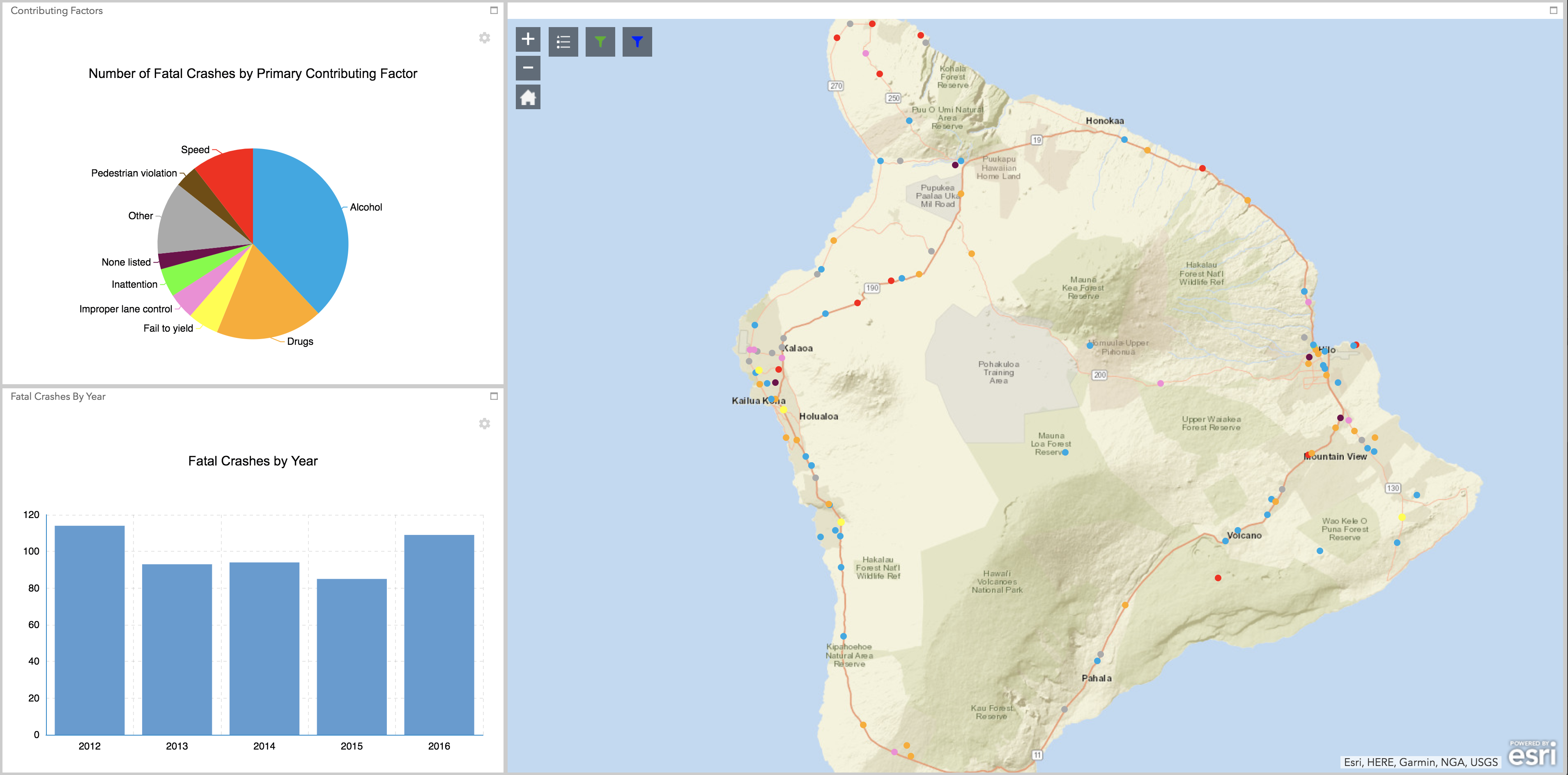
Screen shot image of HDOT map. Hawaii Department of Transportation.
The public can now view pavement conditions and average annual daily traffic volume for state roads on all islands, and view the locations of fatal traffic crashes from 2012 to 2016. The new data also provides monthly updates on current and future road projects.
In July, HDOT released a user-friendly map that shows the schedule, scope, and estimated cost for all current State Highways projects as well as all projects planned to begin construction in the next two years.
“We’re sharing the data we’ve collected with the public in the interest of transparency,” said HDOT Deputy Director for Highways Ed Sniffen. “Now members of the public can easily access highways safety and other helpful information that is used to guide our programs.”
The new data shows Average Annual Daily Traffic as the total volume of vehicle traffic over a road over the course of a year divided by 365 days. HDOT gathers AADT through a combination of permanent, in-ground traffic counting stations, overhead cameras, and temporary traffic counters or tubes.
The Fatal Crash data is compiled from completed traffic investigation reports. To be considered a motor vehicle fatality in the state of Hawaiʻi, a fatal crash must involve a motor vehicle traveling on a traffic way customarily open to the public and must result in a death of at least one person (occupant of a vehicle or a non-motorist) within 30 days of the crash. The data is provided for highway safety and educational purposes only.
According to the data, 495 fatal crashes occurred in the state of Hawaiʻi between 2012 to 2016. The primary contributing factor to 188 (38%) of those crashes was alcohol. Drugs was the contributing factor to 90 (18%) of those crashes, followed by speeding resulting in 52 (10.5%) of the fatal crashes.
According to HDOT data, on Hawaiʻi island there were 112 fatal crashes that occurred between 2012 and 2016. Alcohol was the primary factor in 41 (36.6%) of the fatalities, followed by drugs with 26 (23.2%).
Pavement condition data is gathered by a vehicle mounted unit using a Laser Crack Measurement System (LCMS) that drives over state roads on a biennial basis (each individual road under state jurisdiction is surveyed once every other year, interstates and roadways in the National Highway System are surveyed once a year).
For more information on the LCMS, go online.
The majority of roads on Hawaiʻi island were considered fair.
Datasets such as the pavement conditions and average annual daily traffic figures will be updated on an annual basis. HDOT says fatal crash data is updated as traffic incident reports are finalized and the last year of available data is 2016.
The ESRI powered map is currently optimized for the Chrome browser.
Questions or comments on the map may be sent to DOTPAO@hawaii.gov
Sponsored Content


