

Today’s Big Island Surf Report

Photo Credit: James Grenz
Alerts
Small Craft Advisory Issued: September 26 at 3:20 AM HST until September 28 at 6:00 PM HST by NWS
Areas Affected: Alenuihaha Channel; Big Island Leeward Waters; Big Island Southeast Waters; Maalaea Bay; Pailolo Channel
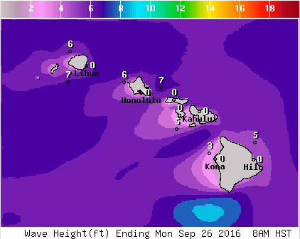
**Click directly on the images below to make them larger. Charts include: Big Island projected winds, tides, swell direction & period and expected wave heights.**
Big Island Surf Forecast
Hilo Side: Surf heights are expected to be in the knee to shoulder high range. Small short period wind waves from the east-northeast rising later in the day. Light and variable northwest winds, Increasing later and switching to the north-northeast.
Kona Side: Surf heights are expected to be in the knee to thigh high range occ. 3ft. Minimal SSW swell.
South: Surf heights are expected to be in the knee to shoulder high range. Small short period wind waves from the east-northeast rising later in the day. Breezy east-northeast winds, whitecapping conditions with moderate choppy seas all day.
Keep in mind surf heights are measured on the face of the wave from trough to crest. Heights vary from beach to beach, and at the same beach, from break to break.
NWS
Sponsored Content


