

Light Winds, Scattered Afternoon Showers Today
Alerts
A High Surf Advisory is posted for northeast facing shores of the Big Island through 6 p.m. Friday. Wave heights are expected from 6 to 10 foot faces.
A Small Craft Advisory is posted for all Big Island channels and waters through 6 p.m. Friday. Hazardous seas up to about 11 feet are expected.
Check our breaking news section for any urgent weather alerts.
**Click directly on the images below to make them larger. Charts include: Big Island high/low forecasted temperatures, projected winds, chance of cloud cover, projected localized weather conditions, vog/SO2 forecast and expected wave heights.**
Looking Ahead
Weakening east to southeast winds will allow sea breezes to develop in the afternoon, with clouds and scattered showers forming mainly over interior and leeward areas. An increase in showers is expected during the weekend into early next week as the front advances closer to the islands.
Today
Today partly sunny skies are expected with scattered showers for windward areas. Scattered showers are expected for the Kona side in the afternoon as the sea breeze develops. High temperatures from 84° to 89°. Variable winds are forecast up to 15 mph.
UV index at 9 (“very high” exposure level)
Tonight
Variable winds are expected in the evening up to 15 mph. Low temperatures from 72° to 77°. Mostly cloudy skies are expected in the evening with scattered showers for windward spots. Leeward spots should see isolated evening showers and clearing as the night goes on.
Our Big Island Now Weather homepage always includes daily: Sunrise | Sunset | Moonrise | Moonset | Moon Phase | Live Weather Cams | 5-day Forecast | Current Temperature & Conditions
**Click here for your detailed Big Island surf report.**

Image: NOAA / NWS

Image: NOAA / NWS

Image: NOAA / NWS

Image: NOAA / NWS
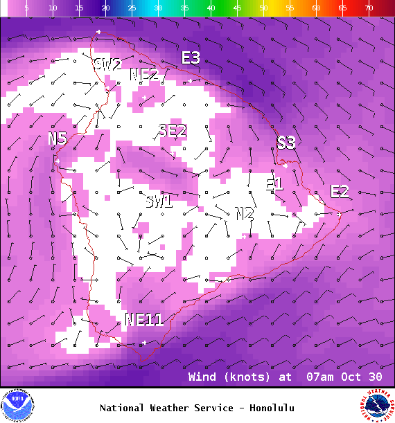
Image: NOAA / NWS

Image: NOAA / NWS

Image: NOAA / NWS
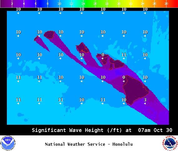
Image: NOAA / NWS
Sponsored Content


