

Partially Shadowed XL Swell Builds Today
Alerts
A Marine Weather Statement has been issued by the National Weather Service for a very large west-northwest swell. The Weather Service in Honolulu says a rapidly building swell will arrive tonight and remain elevated into Thursday. They are warning of strong harbor surges and large breaking waves at harbor entrances exposed to the swell. One location that could expect such conditions is Honokohau harbor.
A High Surf Warning has been issued for the west side of the Big Island. The warning goes into effect this evening at 6:00 p.m. and is posted through Thursday at 6:00 p.m. Wave heights of 15 to 20 foot faces are expected. Expect ocean water occasionally sweeping across portions of beaches, very strong breaking waves and strong longshore and rip currents. Breaking waves may occasionally impact harbors making navigating the harbor channel difficult. Large breaking surf, significant shore break and dangerous currents will make entering the water very hazardous. Boaters should be aware of an increased number of surfers in the water.
A Small Craft Advisory has been issued for all island waters from 6:00 p.m. tonight through 6:00 p.m. Thursday for southwest winds from 10 to 20 knots and rough seas of 8 to 18 feet.
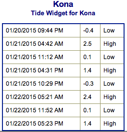
**Click directly on the images below to make them larger. Charts include: Big Island projected winds, tides, swell direction & period and expected wave heights.**
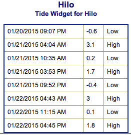 Big Island Surf Forecast, Wednesday, January 21, 2015
Hilo side: Surf heights are expected shoulder to overhead high. The best breaks open to the swell could see occasional larger waves on the sets. Breaks open to the trade swell could see wave heights up to chest high as well.
Kona side: Surf heights are forecasted to be overhead with double to possibly triple overhead wave heights on the sets at select reefs that can handle the size. The swell is expected to peak late in the day.
South: Southerly spots open to the west-northwest swell could get waves wrapping up to overhead in height. Breaks open to the trade swell could see knee to waist high waves.
Our current west-northwest is fading as a new west-northwest builds.
 The new swell is expected to be larger than anything we’ve seen thus far this winter swell season. Surf well above warning levels is expected. This XXL swell is expected to peak Wednesday night and hold through Thursday. The swell is partially blocked by other islands but the Kona side should still see significant swell up to possibly triple overhead at the best breaks at the peak. Hilo coast gets some wrap and could see up to double overhead waves at the best breaks on the sets. Swell will fade late Thursday through Friday.
A reinforcement is expected to move in Friday and begin to fade out on Sunday. Pending development we could see another solid west-northwest swell setting up for Tuesday and Wednesday of next week.
Small south-southwest brings knee to possibly thigh high waves at the best breaks.
Keep in mind, surf heights are measured on the face of the wave from trough to crest. Heights vary from beach to beach, and at the same beach, from break to break.
**Click here for your detailed Big Island weather report.**
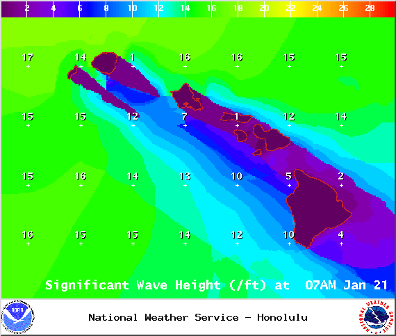
Image: NOAA / NWS
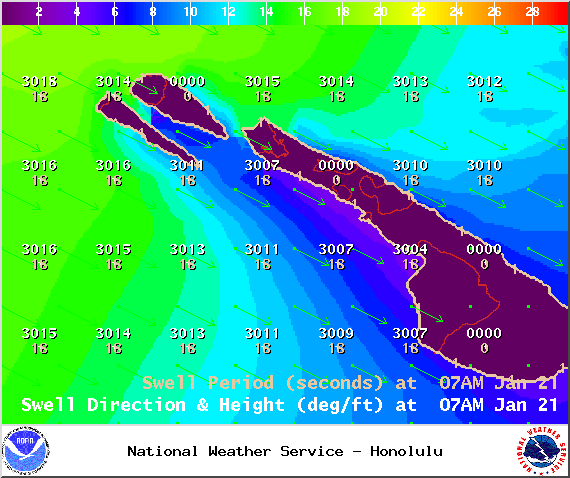
Image: NOAA / NWS
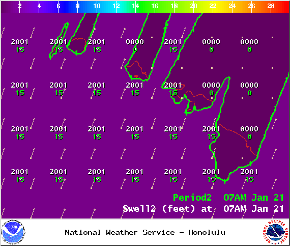
Image: NOAA / NWS
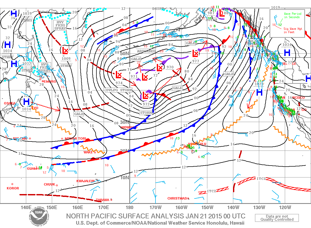
Image: NOAA / NWS
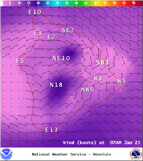
Image: NOAA / NWS
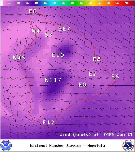
Image: NOAA / NWS
Sponsored Content


