

Weak Front Brings Clouds, Showers This Afternoon
Alerts
A Small Craft Advisory is posted for all Big Island waters through 6:00 p.m. Wednesday for north winds up to 25 knots with higher gusts. Rough seas of 9 to 14 feet are also forecasted late tonight through Wednesday afternoon. Inexperienced mariners should avoid navigating in these conditions.
A High Surf Advisory is posted for north facing shores from 6:00 p.m. this evening through 6:00 a.m. Thursday for a north swell building tonight and peaking Wednesday before gradually diminishing. Expect strong breaking waves, shore break and strong longshore and rip currents making swimming difficult and dangerous.
A Wind Advisory is posted for the summits of Mauna Kea and Mauna Loa through 6:00 a.m. Wednesday for northwest to north winds from 35 to 50 mph with higher gusts. Winds will be strongest over the highest elevations and summit peaks mainly above 11,000 feet. The National Weather Service advises that winds this strong can make walking and driving difficult. Use extra caution when driving and be careful when opening and closing doors. If camping in the area, be sure your tent is well anchored.
**Click directly on the images below to make them larger. Charts include: Big Island high/low forecasted temperatures, projected winds, chance of cloud cover, projected localized weather conditions, vog/SO2 forecast and expected wave heights.**
Today, Tuesday, January 6, 2015
A weak cold front near Maui county this morning will move to the Big Island by this afternoon, and then dissipate tonight. The front will bring a band of clouds and a few showers, mainly to north facing slopes and coasts. Today we expect scattered light showers for windward and mauka areas in the afternoon. Leeward spots are forecasted to be partly to mostly sunny in the morning with cloud cover building in the afternoon. Hazy skies are expected in the afternoon for parts of the Big Island (see UHSOEST vog model above). High temperatures should fall in the range of 75° to 81°. Cool and breezy north winds are expected from 15 to 20 mph.
Sunrise: 6:56 a.m.
Sunset: 5:56 p.m.
UV index at 7 (“high” exposure level)
Tonight
Partly to mostly cloudy skies are expected tonight with scattered windward and mauka showers. On the leeward side cloudy conditions will become mostly clear. Northeast winds are expected from 15 to 20 mph. Low temperatures are forecasted from 64° to 69° degrees.
Moonrise: 7:37 p.m.
Moonset: 8:38 a.m. on Jan. 7
Next New Moon: Jan. 20 at 3:14 a.m.
Next Full Moon: 1:09 p.m. on Feb. 3
Looking Ahead
A weak front is expected to bring a band of clouds and a few showers Tuesday afternoon. Breezy trade winds will fill in behind it along with dry and stable conditions. At the end of the work week models are showing weaker winds veering out of the southeast. These conditions are expected to continue into the weekend with warmer temperatures returning to the Aloha State. Vog may also increase for the Kona side and travel to the other islands with these types of winds.
Almanac for Hilo Airport
Maximum Temperature for today:
Normal 79°
Record 86° / Set in 1962 and tied in 1973 and 1981
Minimum Temperature for today:
Normal 64°
Record 58° / Set in 1985
**Click here for your detailed Big Island surf report.**
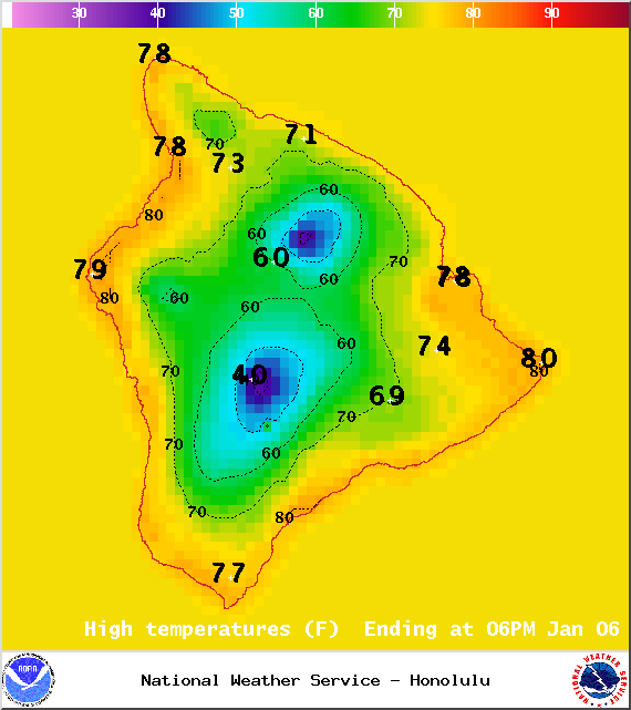
Image: NOAA / NWS
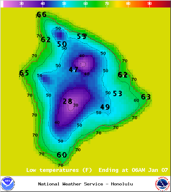
Image: NOAA / NWS
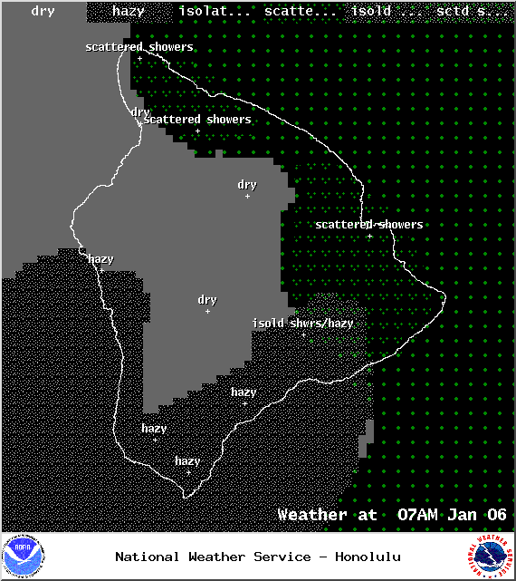
Image: NOAA / NWS
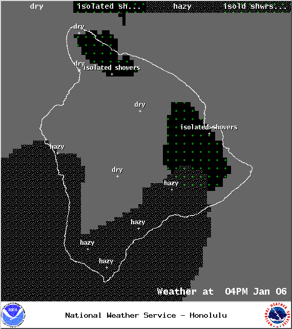
Image: NOAA / NWS
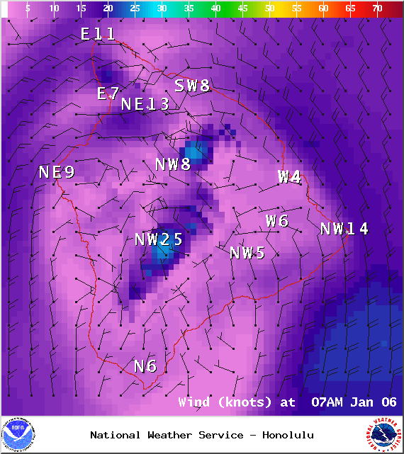
Image: NOAA / NWS
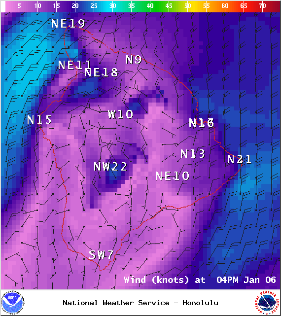
Image: NOAA / NWS
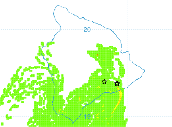
Image: UHSOEST
Image: NOAA / NWS
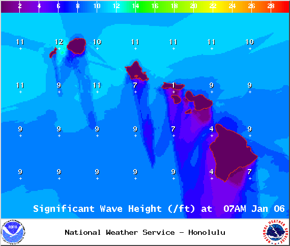
Image: NOAA / NWS
Sponsored Content


