

Volcano Watch: Remembering the 1926 Mauna Loa eruption a century later
Volcano Watch is a weekly article and activity update written by U.S. Geological Survey Hawaiian Volcano Observatory scientists and affiliates. This article is by Natalia Deligne, a geologist with HVO.
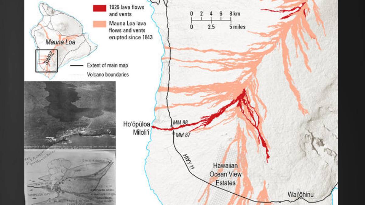
April marked the 100-year anniversary of Mauna Loa’s 1926 Southwest Rift Zone eruption. This eruption is most remembered for the destruction of Ho‘ōpūloa village, a few miles north of Miloliʻi Bay. It also marks the first known instance of aerial photography of an advancing Hawaiian lava flow, and well-organized police-led eruption crowd management.
The 1926 eruption started around 3 a.m. on April 10, following two hours of elevated earthquake activity, including several events large enough to be widely felt. As with all Mauna Loa eruptions observed since 1843, the eruption started in the summit region. Glow was visible across much of the island.
Coincidently, a U. S. Geological Survey expedition led by Edward Wingate was mapping the summit region of Mauna Loa (in 1933, Wingate became the superintendent of Hawaii National Park, now known as Hawaiʻi Volcanoes National Park). They had camped at 11,400 feet elevation about 3½ miles west of the lava outbreak. The Wingate expedition reached the flows around 6:30 a.m., where they witnessed lava fountains from fissures beginning at South Pit, a crater immediately south of Mokuʻāweoweo (the summit caldera). They navigated around active flows, and at one point rapidly retreated to avoid getting trapped by advancing lava.
Summit activity ended by 5 p.m. that day but earthquakes continued, at times strongly felt. This was attributed to magma migrating underground into the Southwest Rift Zone.
On April 13, a yellow plume was seen on the Southwest Rift Zone. It became more prominent and darker on April 14: lava was erupting from the rift zone. Glow from the advancing lava flow was observed that night.
By April 16 the ‘a‘ā lava flow had become a major attraction, with many gathered to watch it cross Government Road (what would later become Highway 11). The lava flow reached the road at 12:22 p.m. and crossed it in about two minutes. Today, Highway 11 traverses the 1926 flow between mile markers 87 and 88 in the District of South Kona.
Concern turned to Ho‘ōpūloa village, downhill from the active flow front. This small coastal fishing village north of Miloliʻi was home to Native Hawaiian and Chinese families. As hundreds travelled to watch the advancing lava, some residents removed their belongings, and numerous offerings were made to Pele.
Lava reached Ho‘ōpūloa village on April 18 around 3 a.m., entered its bay around 6:30 a.m., and completed destroyed the village by 7 a.m. The bay was filled by about 8 a.m., and this branch of the flow stopped advancing by about 9 a.m.
The devastation left an estimated 42 people homeless; many of the displaced moved to Miloliʻi. About 14 houses, a church, and the wharf were destroyed at Ho‘ōpūloa village, in addition to two houses and a Catholic church at Government Road.
The eruption continued until April 30, with another lava flow slowly advancing southeast in the direction of Waiʻōhinu in the District of Kaʻū; it stalled more than 5 miles (8 km) away.
This eruption marks the first time that aerial photos were taken of active Hawaiian lava flows. The U.S. Army Air Corps,11th Photo Section, based at Pearl Harbor, undertook surveys on April 17, 18, and 19. While today aerial surveys are a regular part of the USGS Hawaiian Volcano Observatory’s eruption response, they were revolutionary in 1926. This new capability was a gamechanger for situational awareness of where flows were headed, particularly for flows originating in areas difficult to access on horseback or on foot.
This eruption is also notable for the concerted traffic and tourist management. The previous Mauna Loa eruption in 1919, also along the Southwest Rift Zone, at one point resulted in “a panic,” during which least 20 vehicles were abandoned in a hurry. In 1926, newspaper articles praised the police managing the hundreds of people, with their hundreds of vehicles, who travelled to watch the eruption. To avoid people getting stranded, on April 16 care was taken that those from the Kona side stayed to the north, and those from Kaʻū stayed to the south. Throughout, police directed traffic, established places for vehicles to turn around, and ensured that all vehicles were parked pointed away from the flow in case rapid evacuation was required.
Today, safely maintaining and managing viewing areas remains a key consideration during eruptions in Hawaii. Currently there is no sign of Mauna Loa erupting any time soon and the alert level for Mauna Loa is at “normal.” Monitoring data from Mauna Loa shows ongoing refilling of the summit reservoir system following the 2022 eruption and HVO continues to closely monitor the volcano for signs of renewed activity.
Volcano Activity Updates
Kīlauea has been erupting episodically within the summit caldera since December 23, 2024. Its USGS Volcano Alert level is ADVISORY.
Episode 48 of summit lava fountaining happened for 9 hours on June 1. Summit region inflation since the end of episode 48 indicates that another fountaining episode is possible. Models currently indicate that episode 49 is most likely to occur between June13-15. No unusual activity has been noted along Kīlauea’s East Rift Zone or Southwest Rift Zone.
Mauna Loa is not erupting. Its USGS Volcano Alert Level is at NORMAL.
Five earthquakes were reported felt in the Hawaiian Islands during the past week: a M4.7 event 14 mileas east of Pāpa‘ikou at 24 miles depth on June 9 at 10:37 p.m., a M2.9 event 6 miles south of Hōnaunau-Napo‘opo‘o at 15 miles depth on June 8 at 9:01 p.m., a M2.9 earthquake 1 mile northwest of Hōnaunau-Napo‘opo‘o at 5 miles depth on June 8 at 5:48 a.m., a M3.1 earthquake 11 miles south-southeast of Pāhala at 20 miles depth on June 7 at 1:10 a.m., and a M4.1 event 11 miles southeast of Pāhala at 20 miles depth on June 7 at 12:41 a.m.
HVO continues to closely monitor Kīlauea and Mauna Loa.
Visit HVO’s website for past Volcano Watch articles, Kīlauea and Mauna Loa updates, volcano photos, maps, recent earthquake information, and more. Email questions to askHVO@usgs.gov.
Sponsored Content


