

Raging: ‘Jaw-dropping’ surf on display along Big Island south-facing shores as south-southwest swell peaks
It was shortly before noon Wednesday, June 3, on Ali‘i Drive in downtown Kailua-Kona that The Fish Hopper Kona, during what looked like an already busy lunch service, posted a video that set the bar for gauging the mood of the Pacific Ocean just beyond the seawall on the other side of the street.
Raging.
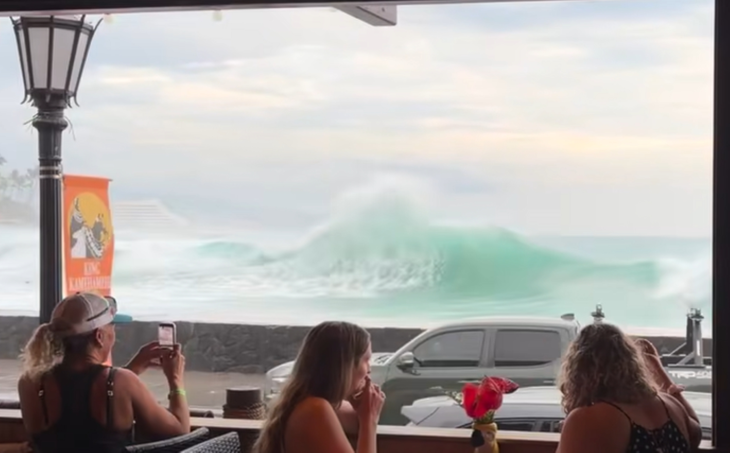
“While our culinary team expertly prepares our renowned dishes, the Pacific Ocean’s majestic display elevates the experience to new heights,” wrote The Fish Hopper in its Facebook post.
New heights were exactly what National Weather Service forecasters in Honolulu were expecting from the sizeable surf bashing south-facing shores of the Big Island.
A high surf advisory remains in effect until 6 p.m. Thursday, June 4, for those shorelines, extended from its earlier original expiration time of 6 a.m. the same day.
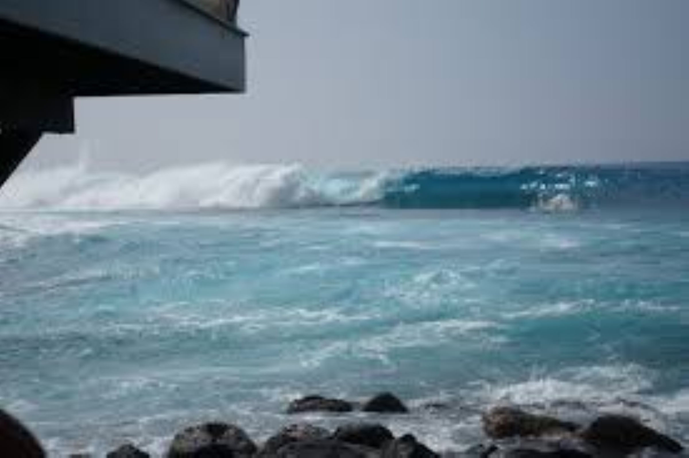
Surf heights were hiked from 8 to 12 feet in the original advisory to now 10 to 14 feet, just below warning levels, in the latest update early Wednesday morning from the Honolulu forecast office.
“Mother Nature is putting on a jaw-dropping display of raw power in Kona,” says a post by World Weather from shortly before noon. “Massive ocean swells are slamming the coastline, sending towering walls of water crashing straight over the seawalls … The sheer force of the Pacific Ocean right now is an incredible reminder of nature’s true strength.”
Chuck Engle arrived at Kailua Bay shortly after 11 a.m., planning to take a light swim, but opted out as soon as he saw the crazy conditions.
“Uh … gonna sit this one out,” Engle wrote in a Facebook post accompanying a video he captured of the rolling waters in the bay, offering his own estimate of wave heights at up to 20 feet, despite forecasters only calling for up to 14 feet. “And I didn’t pack my board.”
The advisory-level surf and south-southwest swell causing it even resulted in the Pride of America cruise shop to forego its Kailua-Kona stop Wednesday. That had somewhat of a domino effect, with at least one event on shore also canceled because of the Norwegian Cruise Line ship skipping the West Hawai‘i port of call.
Kona Choral Society and Windward (O‘ahu) Choral Society also called off their planned noon concert at Mokuʻaikaua Church in downtown Kona. Sherry Bracken posted the announcement just after 10 a.m.
National Weather Service expects the 10 to 14 foot surf to continue slamming southern shorelines of the island through part of tonight before declining to 7 to 10 feet by Thursday morning.
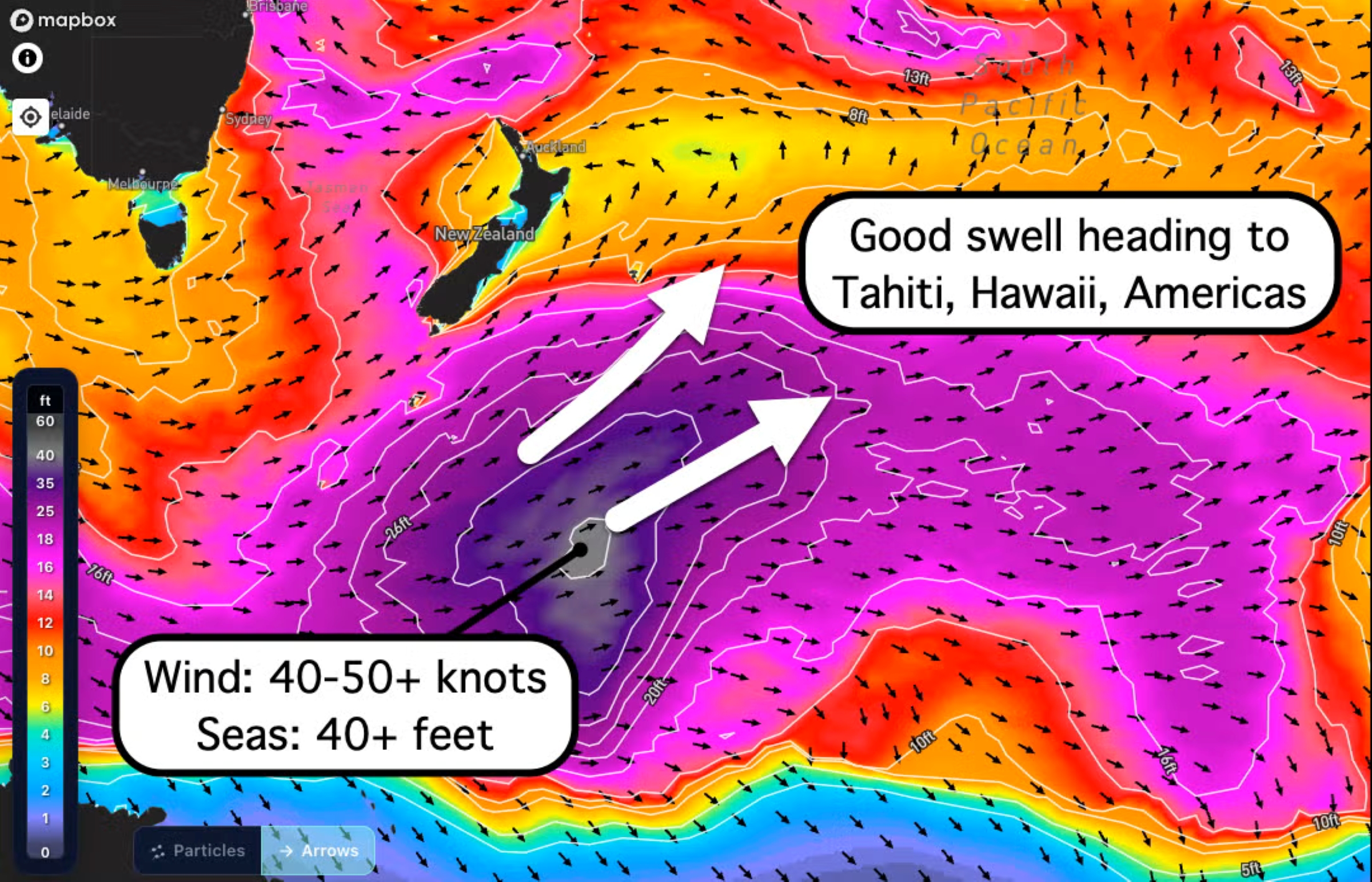
The super summer surf is being powered by a peaking south-southwest swell. Offshore buoys shortly before 10 a.m. Wednesday registered an overnight Tuesday into Wednedsay swell of 6 to 7 feet at 17 second intervals between waves.
Nearshore buoys continued to show the swell at about 6 feet Wednesday morning.
Forecasters say it will begin to gradually decline by evening, with south shore surf likely dropping below advisory threshold of 10 feet by Thursday afternoon. Surf will then fall to moderate levels Friday, June 5, and fade Sunday, June 7, followed by a smaller pulse of south-southwest swell early next week.
The 52-second video posted by The Fish Hopper shows people enjoying the restaurant while watching the undulating ocean just feet away while members of the public and vehicles make their way along the main thoroughfare in Kona.
Within seconds after the recording begins, a massive wave slams into the seawall, breaking and washing over the top and drenching several people who were walking next to it as well as vehicles driving by at the time. Saltwater freely flowing onto the sidewalk and roadway.
Customers watching the scene play out from The Fish Hopper — astonished, maybe even surprised and shocked, at the massive wave and its aftermath they just witnessed — reacted with crescendoing “Ooooo” and “Wooos” as the wave made its impact and subsequent fallout.
There were a few claps from people perhaps with no words but yet cautiously impressed by the power of the Pacific they just watched. Some screams also shrieked from the background as the wave wickedly washed over the shoreline and pummeled the people and vehicles nearby.
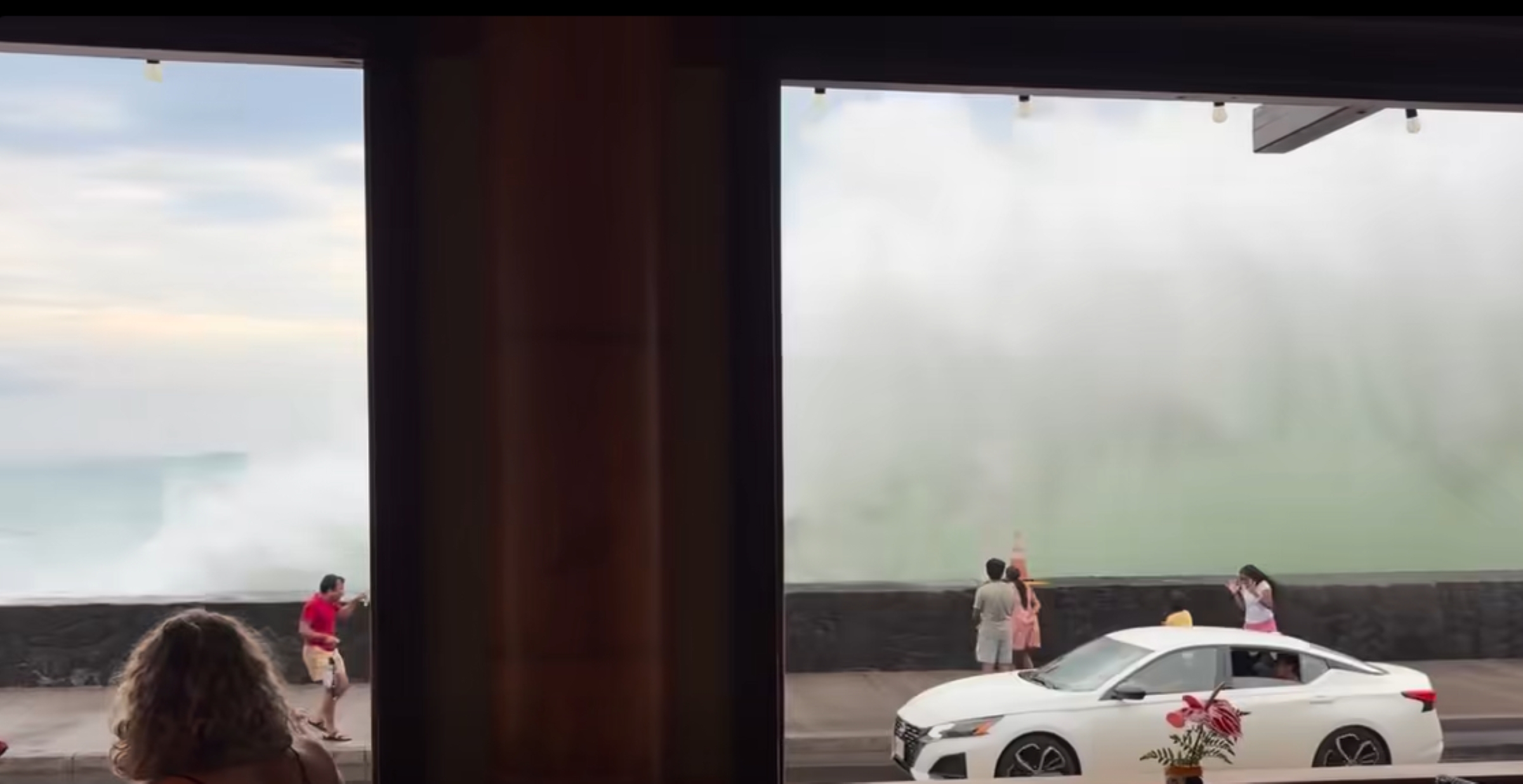
One person behind the cameraman can be heard saying, “They should, they should close that road.”
Customers continued their lunch and conversations, made their way through the dining room on their way out and some took their own photos or video of the savage surf, many — if not most — possibly, if not likely, feeling sea spray each time a wave smashed into the shoreline and wall across the street.
Ocean safety and emergency officials are on high alert because of dangerous ocean conditions created by the high surf while the swell peaks.
Four popular West Hawai‘i beach parks closed because of the high surf and dangers it is creating.
Hawai’i County Civil Defense reported Tuesday night that Kahaluʻu Beach Park; Laʻaloa Park, also known as Magic Sands; Old Kona Airport Beach Park; and Kohanaiki Beach Park.
Civil Defense will keep the public up to date as conditions change.
While it would be best for people to stay out of the water in high surf areas, forecasters advise beachgoers, swimmers and surfers to heed all advice from ocean safety officials and exercise extreme caution.
Boaters should also expect recreational surfers and body boarders using harbor channels to access surfing areas.
Periodic wave runup across roadways can be expected during afternoon high tide Wednesday in areas along southern shores that typically remain dry.
The best advice: When in doubt, don’t go out.
A smaller medium-period north swell is expected to arrive Thursday and peak Friday before easing during the weekend. Surf along north-facing shores is forecast at 2 to 4 feet tonight through Thursday morning before increasing to 3 to 5 feet Thursday afternoon.
Forecasters also expect surf along east-facing shores to gradually build to about seasonal averages by Friday and then hold into early next week.
Sponsored Content


