

UPDATE: Flood warning is canceled and Highway 11 reopens to all traffic, flood watch in effect
Update at 6 p.m. March 23: Highway 11 is now open to all traffic after the flood waters subsided in Kaʻū.
The National Weather Service canceled the flood warning for Hawaiʻi Island and a flood watch remains in effect through tomorrow morning.
A flood watch means conditions are favorable for flooding, but it may not occur. Residents in flood prone areas should be prepared for heavy rains. If lightning threatens your area, the safest place to be is indoors.
The Hawaiʻi County Civil Defense Agency also warns residents that road closures may occur without notice and to not attempt to cross flowing water in a vehicle or on foot.
Konawaena High School, Konawaena Middle School and Ke Kula ʻO ʻEhunuikaimalino remain closed through this week to allow for clean up and repair work.
At Konawaena Middle School and Ke Kula ʻO ʻEhunuikaimalino, some instructional spaces require additional testing and clearance following professional cleaning. Teachers at these schools will be on telework during the week. All other staff are expected to report to campus or assigned work locations to support school operations.
At Konawaena High School, staff will use the week to prepare for the transition to distance learning. The school is scheduled to transition to distance learning beginning Monday, March 30, while remediation efforts continue.
Update at 3:35 p.m. March 23: The flash flood warning has been extended as heavy rain continues over parts of East Big Island, flooding Highway 11 near Pāhala.
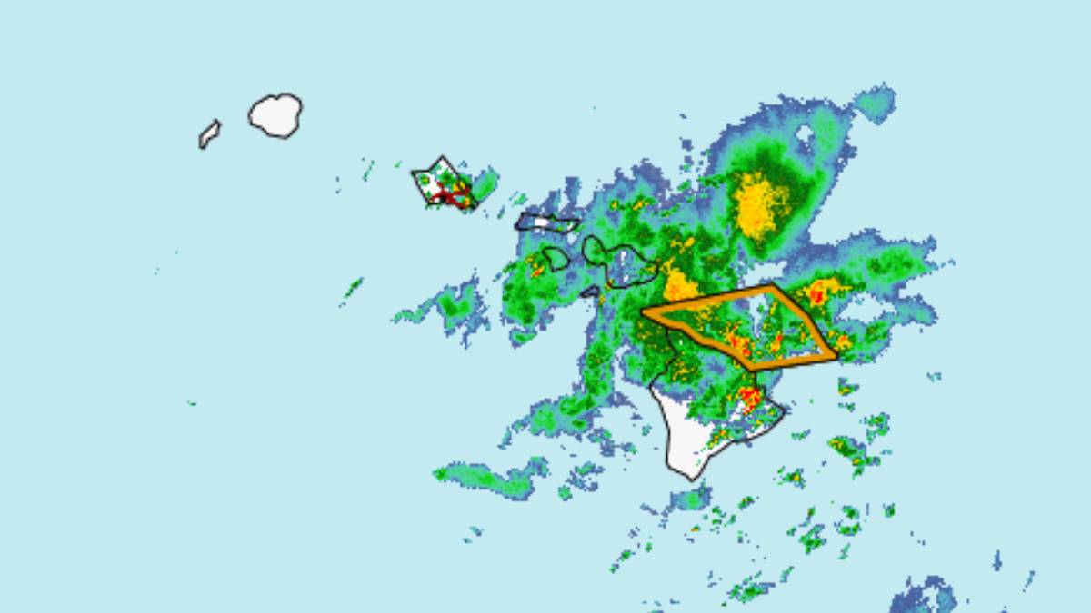
The Hawai‘i Police Department has closed the section of Highway 11 between mile markers 54 and 50 due to flooding.
According to the National Weather Service in Honolulu, the heaviest rain is concentrated over the Kaʻū District between Kāwā Flats and Volcano, with rain falling at 2 to 4 inches per hour.
Life-threatening flash flooding is possible until 6:45 p.m.
There is also snow and freezing rain on the Big Island summits above 12,000 feet. Snow accumulations are reaching up to 2 inches, making travel difficult with blowing snow significantly reducing visibility at times.
Forecasters have issued a winter weather advisory until 6 a.m. Tuesday.
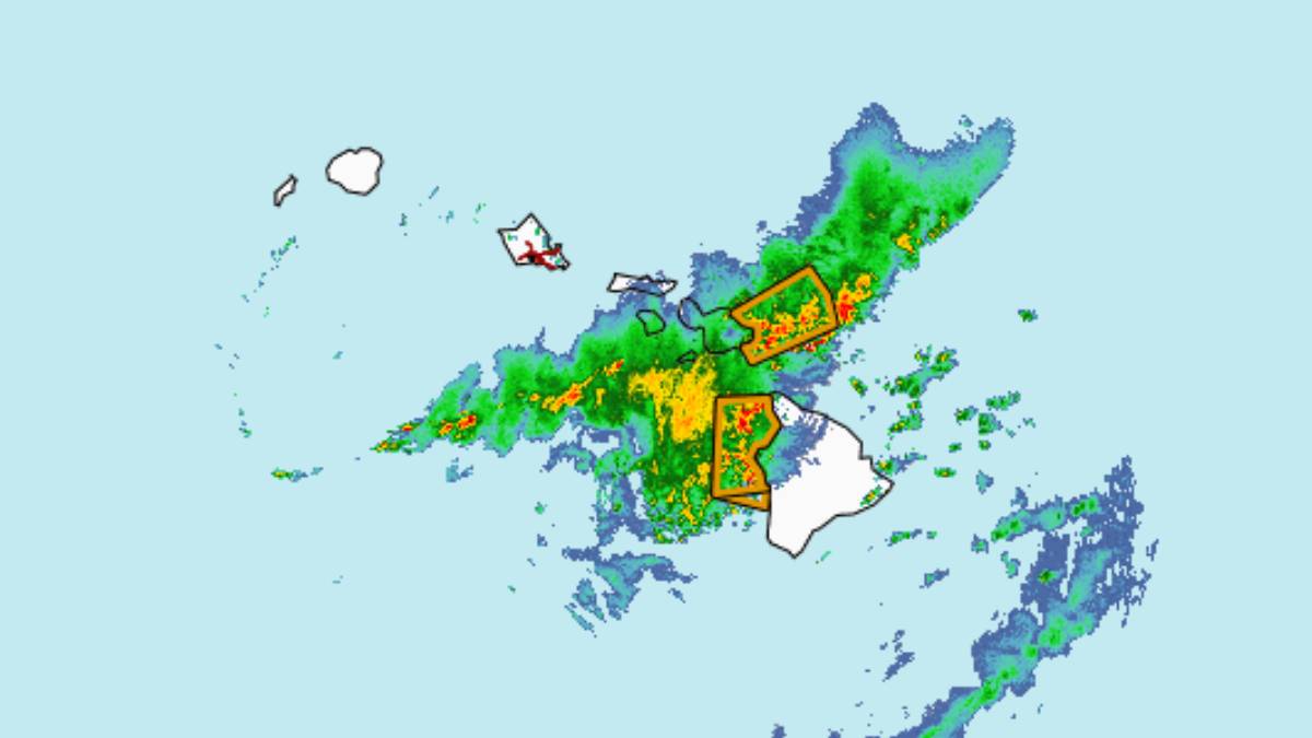
Update at 1:05 p.m. March 23: As strong thunderstorms move slowly over areas of East Hawaiʻi, a flash flood warning has been issued for the Big Island.
According to the National Weather Service in Honolulu, a cluster of strong thunderstorms is moving slowly over South Hilo and Puna, causing wind gusts up to 50 mph and nickel-sized hail.
Gusty winds could knock down tree limbs and blow around unsecured objects. Minor hail damage to vegetation is possible.
Frequent cloud-to-ground lightning is occurring with this storm. Lightning can strike 10 miles away from a thunderstorm. Seek safe shelter inside a building or vehicle.
Locations impacted by the thunderstorms include Hawaiian Acres, Orchidlands Estates, Hilo, Keaʻau, Hawaiian Beaches, Kurtistown, Hawaiian Paradise Park, Eden Roc, Fern Acres, ʻĀinaloa, Mountain View, Fern Forest, and Glenwood.
Radar also indicated that rain was falling at a rate of 2 to 4 inches per hour between Laupāhoehoe and Mountain View. Additional areas of heavy rain could develop elsewhere in the warned area over the next few hours.
The County of Hawaiʻi Civil Defense Agency has also reported road flooding along Bayfront Highway.
Flash flooding is possible in drainages, streams, rivers, roads, properties, and other low-lying areas. Public road closures are possible in some areas. Areas with steep terrain may experience landslides.
Locations that will experience flash flooding include Hilo, Hawaiian Paradise Park, Honokaʻa, Volcano, Glenwood, Mountain View, Hawaiʻi Volcanoes National Park, Hawaiian Acres, Keaʻau, Wood Valley, Pōhakuloa Camp, Papaʻikou, Pēpēʻekeo, Pāhala, Honomū, Pāhoa, and Hakalau.
The flash flood warning replaces the previously issued flood advisory and will be in effect until 3:45 p.m., however, it may be extended if flooding persists.
Update at 12:36 p.m. on March 23: Thunderstorms have moved out of West Hawai‘i and into the Hilo and Puna Districts.
At 12:33 p.m., Doppler radar was tracking a cluster of strong thunderstorms over the area, moving east at 5 mph. There are wind gusts of up to 50 mph.
The storm is expected to last until 1:30 p.m.
Locations impacted include Hawaiian Acres, Wainaku, Orchidlands Estates, Hilo, Glenwood, Kea‘au, Fern Forest, Papaikou, Hawaiian Beaches, Nanawale Estates, Volcano, Kurtistown, Pauka‘a, Hawaiian Paradise Park, Eden Roc, Leilani Estates, Fern Acres, Pahoa, Ainaloa, and Mountain View.
Frequent cloud-to-ground lightning is occurring with this storm. Lightning can strike 10 miles away from a thunderstorm. Seek a safe shelter inside a building or vehicle.
A flood advisory is currently in effect for the area until 3:45 p.m.
At 12:32 p.m., radar indicated areas of heavy rain moving over the eastern half of the Big Island, generally falling at a rate of 1 to 3 inches. The heaviest rain is currently falling between Hilo and Mountain View with localized rain rates of up to 4 inches per hour.
Some locations that will experience flooding include Hilo, Hawaiian Paradise Park, Honoka‘a, Volcano, Glenwood, Mountain View, Hawai‘i Volcanoes National Park, Hawaiian Acres, Kea‘au, Wood Valley, Pōhakuloa Camp, Pōhakuloa Training Area, Papaikou, Pepe‘ekeo, Pahala, Honomu, Pāhoa and Hakalau.
Update at 12:23 p.m. on March 23: A flood warning for West Hawai‘i has been canceled as heavy rain has ended.
A flood watch remains in effect until 6 p.m.
Update at 10:57 a.m. on March 23: Strong thunderstorms will continue to impact portions of Hawai‘i County through 11:30 a.m.
At 10:37 a.m., Doppler radar was tracking a cluster of strong thunderstorms along a line extending from near Kamuela to 6 miles northeast of Kalaoa to 18 miles west of Hawaiian Ocean View. Movement was northeast at 5 mph.
impacted include Waipi‘o Valley, Hawi, Mahukona, Hōnaunau, Kamuela, Kawaihae, Kahalu‘u-Keauhou, Kealakekua, Kapa‘au, Puako, Kailua-Kona, Captain Cook, Pu‘uanahulu, Waikōloa Village, Kainaliu, Honalo, Pololu Valley, Kohala Ranch, Kalaoa, and Halaula.
Frequent cloud-to-ground lightning is occurring with these storms. Lightning can strike 10 miles away from a thunderstorm. Seek a safe shelter inside a building or vehicle.
Original post: Thunderstorms are hitting Hawai‘i County and are expected to linger through 10:30 a.m.
At 9:35 a.m., Doppler radar was tracking a cluster of strong thunderstorms along a line extending from near Hawi to 5 miles southwest of Kahalu‘u-Keauhou.
Ellison Onizuka Kona International Airport at Keahole is under a ground stop due to lightning. All ground crew have been pulled off the ramp area.
Frequent cloud-to-ground lightning is occurring with these storms. Lightning can strike 10 miles away from a thunderstorm, according to the National Weather Service in Honolulu. Seek a safe shelter inside a building or vehicle.
Locations impacted include Captain Cook, Pu‘uanahulu, Hawi, Mahukona, Hōnaunau, Kawaihae, Kahalu‘u-Keauhou, Waikōloa Village, Kainaliu, Kealakekua, Honalo, Pololu Valley, Kohala Ranch, Kalaoa, Halaula, Kapa‘au, Waimanu Valley, Puako, Kailua-Kona, and Hōlualoa.
The movement of the storm was east at 15 mph offshore, with wind gusts of up to 50 mph.
A flood advisory was upgraded to a warning. At 10:22 a.m., radar indicated heavy rain over Kona and Kohala areas. Rain was falling at a rate of 2 to 3 inches per hour.
Flash flooding is ongoing or expected to begin shortly.
HAZARD…Flash flooding caused by heavy rain.
Some locations that will experience flash flooding include Kailua-Kona, Captain Cook, Waikoloa Village, Kapaau, Puuanahulu, Puako, Kalaoa, Holualoa, Kawaihae, Honalo, Kamuela, Kahaluu-Keauhou, Kohala Ranch, Kainaliu, Kealakekua, Honaunau, Waimanu Valley, Waipio Valley, Pololu Valley and Kukuihaele.
Also, the National Weather Service reports there is a special marine warning for leeward waters and the Alenuihaha Channel between the Big Island and Maui, until 10:45 a.m. The storm is producing waterspouts near FAD Buoy XX to 7 nm west of FAD Buoy F, moving east at 10 knots.
Sponsored Content


