

Update 3: Tropical Storm Calvin 580 miles east-southeast of Hilo, forecast to pass over Big Island Tuesday night into Wednesday

Update at 8:14 p.m. July 17: Tropical Storm Calvin is now 580 miles east-southeast of Hilo. The storm is moving west at 21 mph and has a maximum sustained winds of 45 mph, although their are higher gusts.
Hawaiʻi County is under a Tropical Storm Warning.
Update at 4:49 p.m. July 17: Tropical Storm Calvin is now 655 miles east of Hilo and moving west toward the Big Island at 22 mph, according to the National Hurricane Center Monday evening.
The storm has a maximum sustained winds of 45 mph with higher gusts.
Storm rainfall amounts are anticipated to be 4-8 inches from Tuesday night in Thursday, with maximum amounts of 10 inches, mainly along the windward areas of Hawai‘i Island.
One to 4 inches of storm rainfall is expected elsewhere in the state, which could lead to localized flash flooding and mudslides.
Swells generated by Calvin are expected to begin reaching the main Hawaiian Islands during the next couple of days. A rapidly building surf is expected Tuesday night through Wednesday. Surf heights will reach High Surf Advisory levels for most windward coasts, with High Surf Warning levels (greater than 15 feet) along east facing shores of the Big Island.
Although peak surf heights on the Big Island will likely occur around low tide Wednesday morning, some minor overwash and erosion is possible for exposed low-lying coastal areas.
According to the National Hurricane Center, this surf will likely cause life-threatening surf along exposed east-facing shores.
Locally strong winds may begin as early as Tuesday evening across parts of the Big Island, with north winds shifting to the northeast and east as Calvin moves westward. Winds will primarily be northeasterly over the smaller islands, strongest Wednesday and Wednesday night.
It is important to note that the mountainous terrain of the islands can produce localized areas of enhanced winds, even well away from the tropical cyclone center.
Update at 4:07 p.m. July 17: As the result of the approaching Tropical Storm Calvin, the National Weather Service in Honolulu has issued a High Surf Warning southeast and north shores of the Big Island from 6 p.m. Tuesday to 6 p.m. Wednesday.
Expect very strong breaking waves and powerful currents. Waves breaking in channel entrances may make navigating the channels dangerous.
Update at 2 p.m. July 17: Tropical Storm Calvin is now 710 miles east of Hilo and moving toward the Big Island at 22 mph with maximum sustained winds of 50 mph, according to the Central Pacific Hurricane Center.
Update at 11 a.m. July 17: Tropical Storm Calvin is now 790 miles east of Hilo and moving toward the Big Island at 21 mph with maximum sustained winds of 50 mph, according to the Central Pacific Hurricane Center.
Hurricane hunters are flying into the tropical storm to gather more information.
A Tropical Storm Watch remains in effect for the Big Island. It means tropical storm conditions are possible for the island within the next 36 to 48 hours.
On the forecast track, Calvin is expected to The center of Tropical Storm Calvin is forecast to pass over, or very close to the Big Island from Tuesday night into Wednesday.
Calvin is expected to weaken as it moves westward to the south of the other Hawaiian Islands Wednesday and Wednesday night, bringing the potential for some peripheral impacts.
Maximum sustained winds are near 50 mph with higher gusts. Calvin is forecast to gradually weaken during the next several days. The winds extend outward up to 125 miles from the center.
Rainfall: From Tuesday night into Thursday, storm total rainfall amounts of 4 to 8 inches are possible along windward areas of the Big Island, with lower amounts of 1 to 4 inches expected elsewhere in the state. This rainfall could lead to localized flash flooding and mudslides.
Surf: Swells generated by Calvin are expected to begin reaching the main Hawaiian Islands during the next couple of days. A rapid increase in surf is expected Tuesday and Wednesday.
Surf advisory levels for most windward coasts, potentially reaching High Surf Warning levels of greater than 15 feet along east-facing shores of the Big Island.
Although peak surf heights on the Big Island will likely occur around low tide Wednesday morning, some minor overwash and erosion is possible for exposed low-lying coastal areas.
Wind: Locally strong winds may begin as early as Tuesday evening across parts of the Big Island, with north winds shifting to the northeast and east as Calvin moves westward. Winds will primarily be northeasterly over the smaller islands, strongest Wednesday and
Wednesday night. It is important to note that the mountainous terrain of the islands can produce localized areas of enhanced winds, even well away from the tropical cyclone center.
Now is the time to check your emergency plan and emergency supplies kit and take necessary actions to protect your family and secure your home or business. For all you need to know to prepare, click here.
When making safety and preparedness decisions, do not focus on the exact forecast track since hazards such as flooding rain, damaging wind gusts, storm surge, and tornadoes extend well away from the center of the storm.
Original post: A Tropical Storm Watch is in effect for the Big Island, and a Flood Watch was issued for both Maui County and Hawaiʻi Island, from Tuesday night through Wednesday afternoon.
Tropical Storm Calvin will produce periods of heavy rainfall over the Big Island all islands in Maui County that may lead to flooding conditions and landslides, especially along east and southeast facing slopes, according to the National Weather Service.
Primary impacts are expected on the Big Island, “where a period of heavy rainfall is expected, as well as high surf along east facing shores, and locally strong wind gusts.”
At 5 a.m., Calvin was located 920 miles east southeast of Hilo.
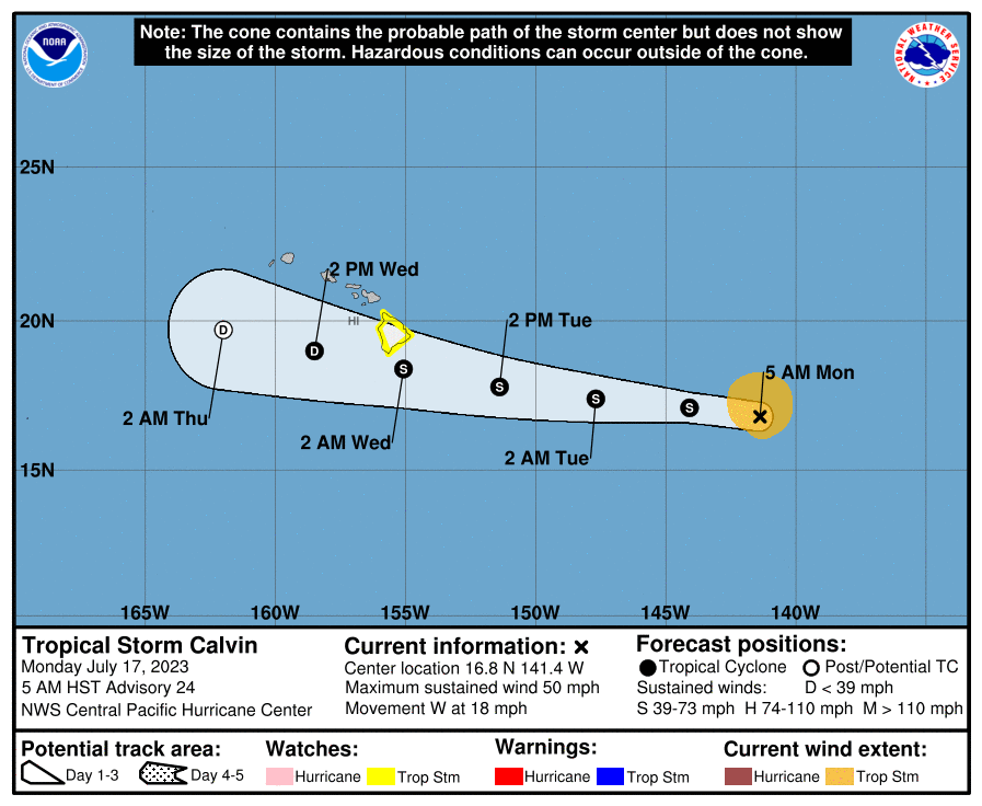
TIMING: Forecasters with the Central Pacific Hurricane Center say Calvin is expected to pass very close to the Big Island Tuesday night and early Wednesday, bringing a period of heavy rain, high surf and locally strong winds. The system is then forecast to weaken as it moves westward to the south of the other islands Wednesday and Wednesday night, brining the potential for some peripheral impacts, according to the CPHC forecast.
According to the latest National Weather Service forecast, “flooding rain will be possible as early as Tuesday evening on the Big Island, and chances for heavy rain is expected to increase for much of the state Tuesday night and Wednesday.”
WIND: The storm has maximum sustained winds of 50 mph with higher gusts and was moving toward the west near 18 mph, according to the Central Pacific Hurricane Center. The Central Pacific Hurricane Center reports that tropical-storm-force winds extend outward up to 105 miles from the center of the storm.
According to the National Weather Service: “Locally strong winds may begin as early as Tuesday evening across parts of the Big Island, with north winds shifting to the northeast and east as Calvin moves westward. Winds will primarily be northeasterly over the smaller islands, strongest Wednesday and Wednesday night.”
RAINFALL: The latest forecast calls for rainfall from Tuesday night into Thursday, with storm total rainfall amounts of 4-8 inches along windward areas of Hawaiʻi Island, and lower amounts of 1-4 inches elsewhere in the state.
SWELLS: On the water, swells generated by Calvin are expected to result in “rapidly building surf” along exposed windward coasts tomorrow night through Wednesday. The National Weather Service reports that Surf Advisory levels are expected for most windward coasts, potentially reaching High Surf Warning levels (greater than 15 feet) along east facing shores of the Big Island. The National Weather Service is forecasting peak surf on Hawaiʻi Island around low tide Wednesday morning.

As the Hurricane Center and Hawaii County Civil Defense Agency continue to monitor Tropical Storm Calvin, it encourages residents to take the time to review family emergency plans and make sure emergency kits and supplies are prepared and ready.
For more information on how to prepare, please visit the Tropical Cyclone Resources at the Hawaiʻi County Civil Defense website at https://hawaiicounty.gov/civil-defense.
Sponsored Content


