

UPDATE No. 2: Calvin maintains Category 3 status; now less than 2,000 miles from Hilo

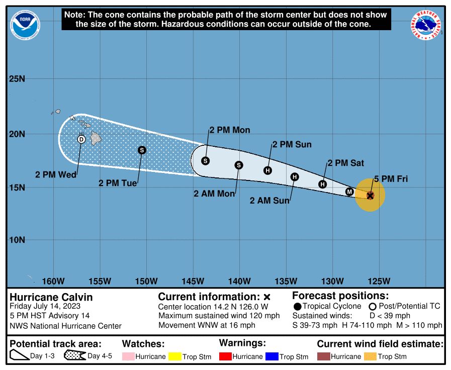
Update at 5 p.m. July 14: As of 5 p.m. Friday, Hurricane Calvin had slightly weakened but was still a Category 3 storm as it continued moving west-northwest toward the Central Pacific — and Hawaiʻi.
The storm was 1,955 miles east-southeast of Hilo and 1,990 miles east-southeast of South Point on the Big Island; 2,205 miles east-southeast of Hāna, Maui; and 2,150 miles east-southeast of Honolulu, moving at 16 mph with maximum sustained winds of 120 mph.
Hurricane-force winds extend outward up to 35 miles from the storm’s center, with tropical storm-force winds extending out up to 115 miles.
Calvin is still expected to stay on its west-northwestward track for the next several days, with additional weakening forecast during the weekend.
The National Hurricane Center in Miami, Fla., says swells generated by Calvin are expected to reach Hawaiʻi shores by early next week and “are likely to cause life-threatening surf and rip current conditions.”
Update at 12:45 p.m. July 14: As of 11 a.m. Friday, Hurricane Calvin had strengthened somewhat but was still a Category 3 storm, with maximum sustained winds of 125 mph, according to the National Hurricane Center in Miami, Fla.
The hurricane was moving at 16 mph, still to the west-northwest. The storm is expected to continue that motion for the next several days. Hurricane-force winds extended outward up to 35 miles from the storm’s center, with tropical storm-force winds extending outward up to 115 miles.
Calvin was 2,050 miles east-southeast of Hilo and 2,085 miles east-southeast of South Point on the Big Island; 2,115 miles east-southeast of Hāna, Maui; and 2,255 miles east-southeast of Honolulu.
The storm is expected to begin weakening Saturday and continue to do so through early next week.
Calvin or its remnants are still expected to continue moving closer to the Hawaiian Islands and could bring impacts as early as Tuesday, but most likely late Tuesday into Wednesday, according to the National Weather Service forecast office in Honolulu. However, it remains too early for specifics at this time.
Original story: In the eastern Pacific, Calvin has rapidly intensified into a major Category 3 hurricane, with maximum sustained winds of 120 mph, according to the National Hurricane Center.
The system was last located about 1,080 miles southwest of the southern tip of Baja California; 2,140 miles east southeast of Hilo on the Big Island; and 2,210 miles east southeast of Hāna on Maui. It is moving west at 16 mph.
The current National Hurricane Center forecast indicates that hurricane-force winds extend outward up to 30 miles from the center, and tropical-storm-force winds extend outward up to 115 miles.
Calvin is expected to move into the Central Pacific Basin late Sunday or early Monday, according to forecasters.
Some additional strengthening is possible Friday as Calvin remains embedded within a moist, low-shear environment over sufficiently warm sea-surface temperatures.
The hurricane is expected to move into cooler waters on Saturday that will cause the intensity to level off.
Earlier next week, Calvin is likely to continue weakening as it encounters less favorable environmental conditions with increased deep-layer shear and drier mid-level environment along its tracks.
Calvin’s remnants will likely impact the state beginning next week Tuesday, but forecasters with the National Weather Service say itʻs still too early for details.
The National Hurricane Center says additional strengthening is possible today, with the intensity expected to level off by tomorrow when it moves over cooler waters. The National Hurricane Center says Calvin is likely to continue weakening as it encounters less favorable environmental conditions on its track.
Forecasters with the National Hurricane Center say, “given uncertainties about the status and intensity of Calvin near the end of the 5-day period, interests in Hawaiʻi should closely monitor the latest forecast updates.”
For now, moderate to breezy trade winds are expected to last into early next week, before potential impacts from Calvin become a possibility.
Sponsored Content


