

Hurricane Calvin continues westward trek; storm could reach Hawai‘i next week

As of shortly before 6 p.m., Hurricane Calvin looked like it was on the cusp of entering the Central Pacific region. The now-Category 2 storm is on a track that could bring it to Hawai‘i, albeit likely not as a hurricane.
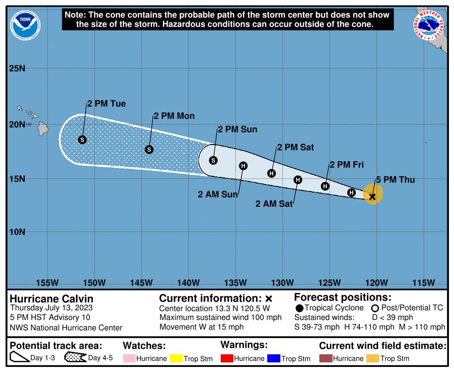
According to the National Hurricane Center in Miami, Fla., Hurricane Calvin was located about 960 miles southwest from the tip of Baja California and 2,325 miles east-southeast of Hilo as of 5 p.m. Thursday, moving west at about 15 mph. The storm was quickly strengthening and had maximum sustained winds of 100 mph, with higher gusts.
Hurricane-force winds extend outward up to 25 miles from the storm’s center and tropical storm-force winds extend outward up to 90 miles. There are no coastal watches or warnings in effect at this time.
The forecast cone for the storm’s center shows it nearing Hawai‘i potentially somewhere to the southeast of the Big Island by the early afternoon of July 18 as a tropical storm. Forecasters are not yet certain what the storm’s impact on Hawai‘i will be, but this is a good time to prepare.
“Forecast uncertainty is high on what, if any, impacts would be for the storm that recently formed well east of Hawai‘i, but preparedness is key,” said a tweet early Thursday afternoon from the National Weather Service in Honolulu.
Calvin is moving in a west to west-northwest motion, which is expected to continue during the next few days as it continues to be steered a strong mid-level ridge centered over the southwestern United States. Some additional strengthening is forecast during the next day or so, with gradual weakening expected to begin by this weekend as the hurricane begins to move over cooler water.
Deep-layer vertical wind shear also is expected to gradually increase, which also should weaken the storm as it continues its trek westward.
Sponsored Content


