

Update: Flood watch for Big Island through Wednesday evening; special marine watch until 8:15 a.m.
Update at 6 a.m. on Wednesday: The National Weather Service said a flood watch for the entire Big Island will continue until Wednesday evening.
Highway 11 between Nāʻālehu and Punaluʻu in the 60 mile area is now open.
The National Weather Service also issues a special marine warning for Alenuihaha Channel, Big Island leeward waters and Maui County leeward islands, with showers at 6:07 a.m. moving to the northeast at 20 knots bringing gusty winds and heavy downpours. Gusts of 34 knots or greater are expected until 8:15 a.m.
Due to the flood watch, the following are issued:
- Roadways may close without warning.
- All Residents in flood prone areas are asked to remain alert for flooding conditions.
- Heavy rainfall and ponding will cause hazardous driving conditions.
- Do not attempt to cross flowing water in your vehicle or on foot; turn around don’t drown.
Update at 7 p.m. on Tuesday: The National Weather Service has upgraded to a flood advisory for the east side of the Big Island.
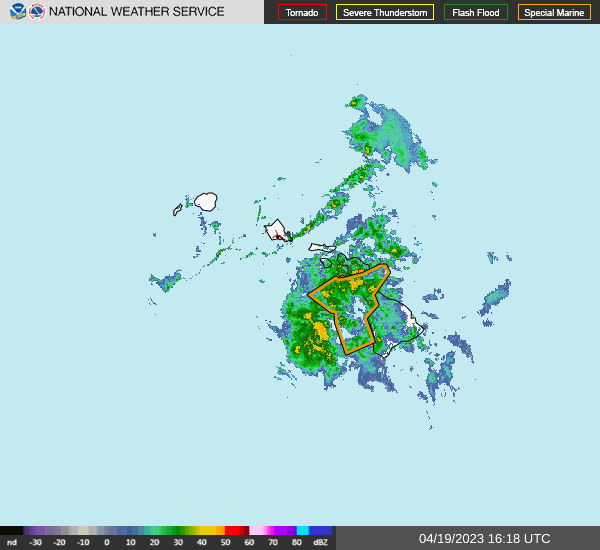
At 6:52 p.m., radar indicated heavy rain over the southeast slopes of the Big Island, with the heaviest rain falling between Naʻalehu and Pāhoa. Rain was falling at a rate of 1 to2 inches per hour.
Some locations that will experience flooding include: Hawaiian Paradise Park, Hawaiʻi Volcanoes National Park, Volcano, Glenwood, Mountain View, Wood Valley, Pahala, Hawaiian Acres, Orchidland Estates, Punaluʻu Beach, Pāhoa, Kawa Flats, Naʻalehu, Fern Forest, Eden Roc, Fern Acres,Kalapana, Kurtistown and ʻĀinaloa.
Stay away from streams, drainage ditches and low lying areas prone to flooding.
Original post: The National Weather Service has issued a flood watch through Wednesday night on the Big Island.
Conditions will be favorable for the development of heavy showers and thunderstorms tonight through Wednesday night. The heaviest rain is expected over the slopes of the Kaʻu and
Puna districts.
Flash flooding caused by excessive rainfall is possible.
Flood prone roads and other low lying areas may be closed due to elevated runoff and overflowing streams. Urban and leeward areas may receive more significant flooding and property damage due to rapid runoff.
Sponsored Content


