


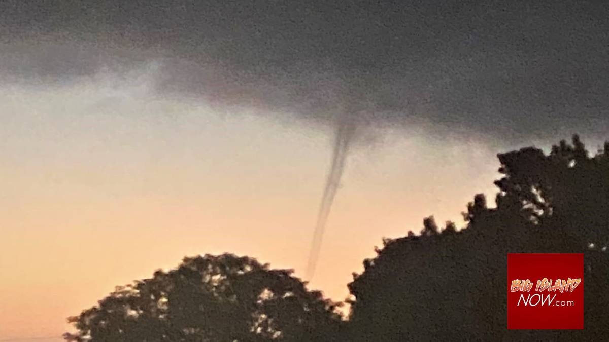
Photo captures likely waterspout; a rarity in Hawaiʻi
Sally Rankin posted a picture shortly after 6 p.m. on Nov. 9 on Facebook that shows a small cloud rope descending from a dark sky near her West Hawai‘i home.
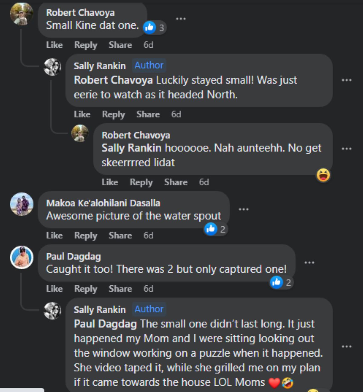
“Hung out for about 5 minutes [in] Kealakekua/Honalo just now,” Rankin said in the post. “Disappeared on [its] way towards Kona.”
Within three minutes of Rankin’s post, the question was asked: Is that a tornado?
While working on a puzzle with her mother, Rankin took a photo of the swirling cloud they saw through a window in her living room. The photo has generated a whirlwind of interest, with more than 100 comments and two Facebook posts asking about it.
“There was definitely something brewing in the air for a short moment,” commented Michelle Mills Kramer on Rankin’s post.
The consensus among those commenting was the image likely was a waterspout. The main distinction between a tornado and a waterspout is that a waterspout occurs over water and a tornado over land, according to the National Weather Service in Honolulu.
National Weather Service meteorologist Robert Bohlin in Honolulu said he wasn’t sure if anyone reported a waterspout on Nov. 9, so couldn’t say what was pictured in Rankin’s photo. Bohlin explained fair-weather waterspouts can be difficult for meteorologists to detect on radar because they can occur under convergent cumulus cloud bands. That’s why databases of their occurrences are based mostly on reports from the public.
Part of the excitement surrounding Rankin’s photo is that weather phenomena such as waterspouts, tornados and funnel clouds are a rare sight in the Hawaiian Islands.
There have been a total of just 42 reports of tornadoes in the state since Jan. 1, 1950, according to the National Oceanic and Atmospheric Administration’s National Centers for Environmental Information Storm Events Database. The most recent was just before 3 p.m. April 23, 2015, in Ewa Beach on O‘ahu. A weak tornado formed and dissipated without incident.
There have been only 63 reports of funnel clouds forming over the state in the same time period, the last was at 2 p.m. Sept. 15, 2021, near Wahiawa on O‘ahu.
Just 31 reports of waterspouts have been made since Jan. 1, 1950, throughout the islands, with the most recent report coming in May 2001 from Hilo. There also was a report of a waterspout that same year in April in Kailua-Kona.
The events seem to be even more rare on the Big Island.
From Jan. 1, 1950, through Nov. 16 this year, there have been just 10 reports of tornadoes in Hawai‘i County. The most recent was reported Feb. 27, 2004, in Kaʻū. The twister mainly impacted the Namakani Paio campground west of Volcano and downed many trees in the area. Some homes in the area also were damaged by the falling trees and some power lines were snapped or downed.
There also have been just 10 reports of funnel clouds in Big Island skies during the same time period. The last report was March 31, 2020, in Waikōloa Village.
Fortunately, no injuries were reported in any of those recent events.
There are two types of waterspouts: one is a regular tornado that occurs with a severe thunderstorm over water, called a tornadic waterspout; the other, a fair-weather waterspout, typically forms beneath cumulus or cumulus congestus clouds, not full-blown thunderstorm clouds, according to the Department of Meteorology and Atmospheric Science in the Penn State College of Earth and Mineral Sciences.
Fair-weather waterspouts tend to form in humid air masses over very warm water.
“Both waterspouts can be severe to anyone on the water; however, the non-thunderstorm waterspouts are not as powerful as their thunderstorm driven cousins,” meteorologist Bohlin said.
While the picture clearly shows something was spinning in the atmosphere that Wednesday afternoon over West Hawai‘i, the National Centers for Environmental Information database shows no reports of waterspouts, tornadoes or funnel clouds anywhere in the state this year.
While there were some dark clouds Nov. 9 in West Hawaiʻi, the area only received a trace of rain, according to preliminary data from the National Weather Service. There was some wind, with an average speed of about 7 mph that day, and winds did pick up between 4 and 6 p.m., increasing from 3 mph just before 4 p.m. to 18 mph shortly after and up to 23 mph just before 6 p.m., with a peak wind speed of 29 mph.
There also were no severe weather advisories issued by the National Weather Service on Nov. 9.
While spinning clouds donʻt happen often in the Aloha State, there have been cases in which they have caused damage and injuries, including a waterspout that struck Kailua-Kona at 10:50 a.m. Jan. 28, 1971.
“In 1971, the waterspout in Kailua Bay moved ashore and was then considered a tornado, so in that case it was both,” said John Bravender, warning coordination meteorologist at the National Weather Service in Honolulu.
“A large waterspout sweeping into Kailua Bay from the ocean damaged two glass-bottom boats, crossed a seawall and wharf and cut a swath through the downtown business and hotel district of Kailua-Kona,” said the report on the storm event database. “The funnel tore roofs and walls off waterfront houses, a hotel and a newly completed shopping mall, demolished the building housing the post office and a bank, collapsed a six-story hotel under construction into a pancake-like heap of twisted girders and concrete slabs and damaged a number of cars, two service stations and an auto center.”
The waterspout then moved upslope into an apartment project, damaging 40 units and requiring 79 residents to be relocated. Fortunately, just one of the four people injured required hospitalization.
The 100-yard-wide twister went on a 1-mile trek and caused a conservative estimate of $1.5 million in damage.
Earlier that same day in 1971, a possible tornado was reported at 5:15 a.m. at Honomalino Farms in South Kona. The report says the storm uprooted more than 2,500 macadamia nut trees and damaged a house.
Some of those who commented on Rankin’s post also reported seeing other swirling formations in the sky Nov. 9.
“Caught it too!” commented Paul Dagdag. “There was 2 but only captured one!”
The rare sight, which caused Rankin’s mother to ask about her plans if the swirling cloud came toward the house, was short-lived and small. But it is likely something they will not forget.
“Luckily stayed small!” Rankin said in a reply to one of the commenters on her post. “Was just eerie to watch as it headed north.”
Sponsored Content


