

Volcano Watch: HVO Responds to American Samoa Earthquake Reports
Volcano Watch is a weekly article and activity update written by U.S. Geological Survey Hawaiian Volcano Observatory scientists and affiliates.
Earthquakes have been felt since late July in the Manuʻa Islands of American Samoa in the South Pacific. These earthquakes are likely associated with magmatic activity beneath the islands. The USGS Hawaiian Volcano Observatory (HVO) is working closely with federal partners, American Samoan officials, and local residents to better understand the source and potential hazard implications of these ongoing earthquakes.
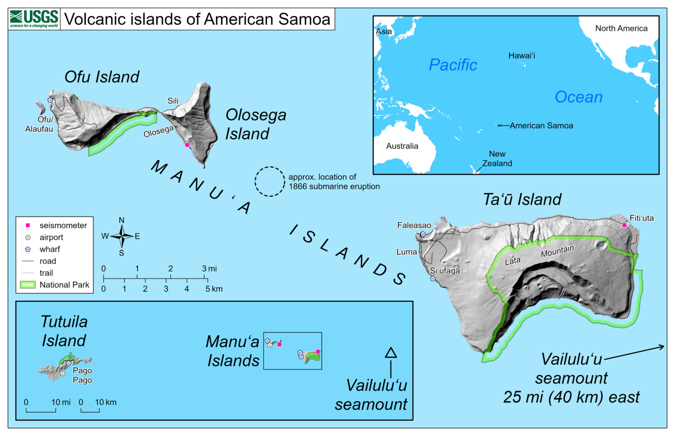
Volcanoes in American Samoa are similar to those in Hawaii, with the Pacific Plate moving to the northwest over the Samoa hotspot and building submarine volcanoes that eventually emerge from the ocean as islands. These islands are the tops of large basaltic shield volcanoes rising over 15,000 feet (4,500 m) from the surrounding seafloor.
The Samoan hotspot is currently centered on Vailuluʻu seamount, which has had several historic eruptions. The Manuʻa Islands of Ofu, Olosega, and Ta‘ū—along with the main island of Tutuila—are all considered potentially active as they have erupted within the last 10,000 years.
Tutuila is the most populous island in American Samoa and is where the capital city of Pago Pago is located. The youngest dated eruption in American Samoa on land is on Tutuila and occurred approximately 1400–1700 years ago. However, numerous submarine eruptions have occurred more recently at volcanoes east of Tutuila.
The Manu‘a Islands, located about 60 miles (97 km) east of Tutuila, include Ofu, Olosega and Taʻū. Ofu and Olosega, separated by the narrow Asaga Straight, are the tops of two shield volcanoes. Taʻū, the largest of the Manuʻa group, is a shield volcano with rift zones to the northeast and northwest. In 1866, a submarine eruption formed a cone between Taʻū and Olosega.
The Vailuluʻu seamount, the youngest Samoan volcano, is located about 25 miles (40 km) east of Taʻū. It is a submarine volcano with a summit about 2,000 feet (600 m) below sea level. Vailuluʻu has erupted multiple times over the past 50 years. During the past twenty years, a young cone has grown within the summit caldera.
Based on felt reports and historic activity, Taʻū and Vailuluʻu were identified as likely possible sources for the recent earthquakes. It was initially difficult to confirm the source because, until a few days ago, there were no seismometers close enough to determine the distance to the source of the earthquakes.
The latest data, obtained from rapidly deployed microseismometers, indicate that the source is closer to Taʻū than Olosega and not close to Vailuluʻu. The earthquake swarm is most likely due to magma movement beneath the volcanoes and not tectonic faulting.
HVO became aware of these earthquake reports on August 7. HVO and federal partners—NOAA National Weather Service (NWS) Office in Pago Pago, NOAA Pacific Tsunami Warning Center, NOAA-IOC International Tsunami Information Center, NPS National Park of American Samoa, NOAA National Marine Sanctuary of American Samoa, and USGS National Earthquake Information Center—are working closely together with American Samoa officials to respond to this evolving situation.
HVO staff traveled to American Samoa on August 11 to consult with federal partners, local officials and residents. They are working with NWS staff and local residents to install volcano-monitoring equipment. Additional HVO scientists and equipment will arrive in American Samoa later this week.
The USGS Alaskan Volcano Observatory (AVO) and the Wellington Volcano Ash Advisory Center (VAAC) are monitoring American Samoa using remote sensing satellite data, which could show thermal anomalies, volcanic plumes, or volcanic gases related to potential volcanic activity.
It is unclear if this unrest will escalate to a volcanic eruption. If an eruption does occur, it will most likely include slow-moving lava flows or low-level explosions that are localized to a small area. Other hazards could include volcanic gases, ground shaking, and local tsunami. An eruption like Hunga Tonga–Hunga Ha’apai in Tonga earlier this year is extremely unlikely as it is a different type of volcano. Volcanoes in Tonga erupt much more explosively than ones in American Samoa and Hawaii.
HVO would like to acknowledge every agency and every individual person who has contributed to this response. We especially thank Manuʻa island residents for their observations. Mahalo and Fa’afetai!
You can read more about the activity on the Taʻū Island USGS website: https://www.usgs.gov/volcanoes/ta-u-island.
Volcano Activity Updates
Kīlauea volcano is erupting. Its USGS Volcano Alert level is at WATCH (https://www.usgs.gov/natural-hazards/volcano-hazards/about-alert-levels). Kīlauea updates are issued daily.
Over the past week, lava has continued to erupt from the western vent within Halemaʻumaʻu crater. All lava is confined within Halemaʻumaʻu crater in Hawai‘i Volcanoes National Park. Sulfur dioxide emission rates remain elevated and were last measured at approximately 1,150 tonnes per day (t/d) on August 12. Seismicity is elevated but stable, with few earthquakes and ongoing volcanic tremor. Over the past week, summit tiltmeters recorded several deflation-inflation sequences (DI-events). For more information on the current eruption of Kīlauea, see https://www.usgs.gov/volcanoes/kilauea/recent-eruption.
Mauna Loa is not erupting and remains at Volcano Alert Level ADVISORY. This alert level does not mean that an eruption is imminent or that progression to an eruption from the current level of unrest is certain. Mauna Loa updates are issued weekly.
This past week, about 96 small-magnitude earthquakes were recorded below the summit and upper elevation flanks of Mauna Loa—the majority of these occurred at shallow depths less than 15 kilometers (9 miles) below sea level. Global Positioning System (GPS) measurements show low rates of ground deformation over the past week. Gas concentrations and fumarole temperatures at both the summit and at Sulphur Cone on the Southwest Rift Zone have remained stable over the past week. Webcams show no changes to the landscape. For more information on current monitoring of Mauna Loa, see: https://www.usgs.gov/volcanoes/mauna-loa/monitoring.
One earthquake was reported felt in the Hawaiian Islands during the past week: a M3.4 earthquake 7 km (4 mi) E of Pāhala at 34 km (21 mi) depth on August 16 at 4:37 p.m. HST.
HVO continues to closely monitor Kīlauea’s ongoing eruption and Mauna Loa for any signs of increased activity.
Please visit HVO’s website for past Volcano Watch articles, Kīlauea and Mauna Loa updates, volcano photos, maps, recent earthquake info, and more. Email questions to askHVO@usgs.gov.
Volcano Watch is a weekly article and activity update written by U.S. Geological Survey Hawaiian Volcano Observatory scientists and affiliates.
Sponsored Content


