

Volcano Watch: Picturing a Plume
Volcano Watch is a weekly article and activity update written by U.S. Geological Survey Hawaiian Volcano Observatory scientists and affiliates.
The volcanic gas plume at the summit of Kīlauea Volcano in Hawai‘i Volcanoes National Park is often the most visible indication of the ongoing eruptive activity during the daylight hours. On some days, it can also be quite easy to smell the gas plume, if the winds blow it toward accessible areas.
But is what you see what you smell?
Surprisingly, no! When you see a volcanic plume on the Island of Hawai‘i, you may see a few different colors—white, or bluish, or brownish. Those different colors result from atmospheric scattering by liquid water droplets (white) and sulfate aerosols (blue, brown) in the plume. What you smell is sulfur dioxide (SO2), which is invisible to our eyes.
Observations of SO2 are critical to both tracking and understanding eruptive behavior. The USGS Hawaiian Volcano Observatory relies heavily on measurements of SO2 emission rate, which is often used as a proxy for volcanic activity. Such measurements are also critical for vog (volcanic air pollution) forecasts and can be used for calculating lava eruption rates.
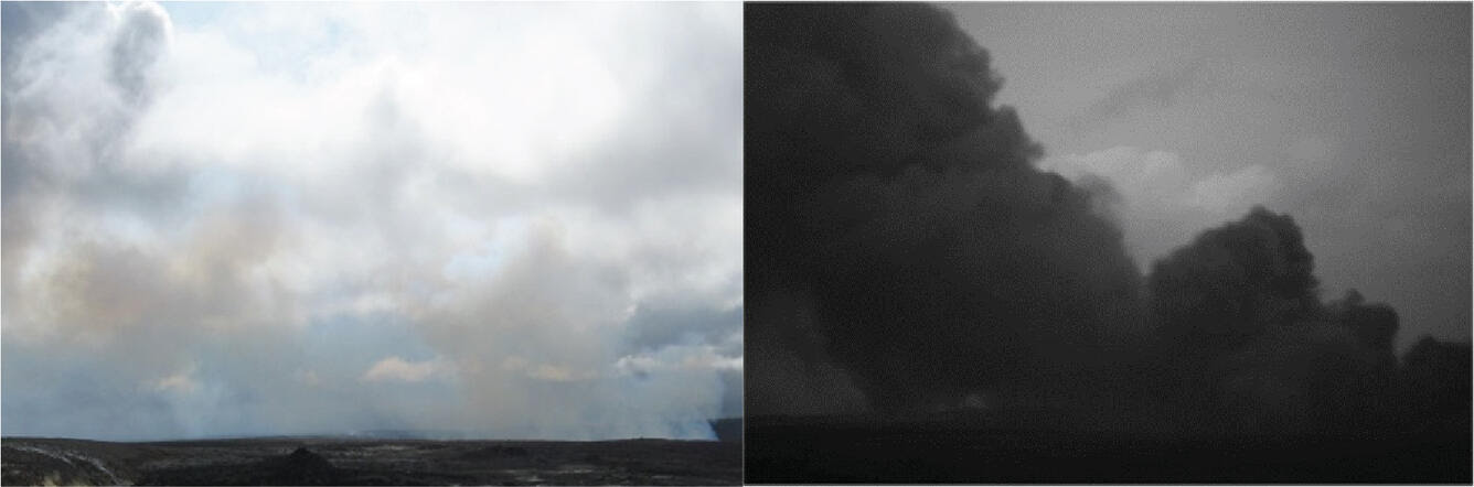
HVO also relies heavily on cameras to document activity, including both visual and thermal cameras. A third type of camera—an ultraviolet (UV) camera—allows volcanologists to visualize those important, and otherwise invisible, SO2 plumes. SO2 absorbs ultraviolet light, which makes it visible in UV imagery even when it cannot be seen by standard cameras.
UV cameras have been used at Kīlauea before. Patricia Nadeau, current member of the HVO gas geochemistry group, studied the summit plume using a UV camera in 2010 while a graduate student at Michigan Technological University. Later, in 2013, a combined effort between the Cascades Volcano Observatory (CVO) and HVO resulted in the installation of an automated UV camera system at the summit of Kīlauea. That camera station was removed in 2018 when it was threatened by ground cracking associated with summit caldera collapse events. A campaign-survey-style UV camera was also used for part of the 2018 lower East Rift Zone eruption response, but HVO has not utilized such cameras much since then.
Now, with lava and strong SO2 degassing having returned to Kīlauea summit in late 2020, HVO and CVO are teaming up with colleagues at the University of Sheffield in the United Kingdom. The UK scientists have developed a new generation of small UV cameras that use Raspberry Pi technology. A Raspberry Pi is a small, low-cost computer, about the size of a credit card, and HVO has used them in other applications before.
The new cameras—PiCams—will be tested later this month and can be used as portable field tools or installed as permanent stations in HVO’s monitoring network. Pending the outcome of the initial tests, HVO plans to install at least one PiCam permanently at Kīlauea’s summit. A second PiCam will either be kept portable for flexibility or will eventually be installed near Mauna Loa’s summit.
SO2 emission rates can also be derived from UV camera images. Traditional SO2 emission rate measurements are made by traversing beneath the plume with a UV spectrometer mounted on a car, so that each measurement takes ten or more minutes, with only 6–10 of those measurements made per day. Beginning in 2012, HVO pioneered a network of continuous spectrometers to measure Kīlauea’s SO2 emission rate at a much higher temporal resolution than possible with vehicle-based measurements, but the network did not provide spatial information about the SO2 plume.
Once the PiCams are ready for use, they will provide both a 2-dimensional view of Kīlauea’s SO2 degassing as well as a high-temporal resolution, continuous timeseries of SO2 emission rate measurements.
The continuous SO2 emission rate data will make it easier to study degassing in conjunction with other continuous datasets, like earthquake activity and ground deformation. This will give greater insight into the role of degassing in specific eruptive events, something that has not always been easy to do in the past. Similar work has been done over the past decade at many volcanoes around the world—including here at Kīlauea, where earthquake activity and SO2 emissions were shown to be linked during lava lake rise-fall events in 2010. The current lava lake in Halema‘uma‘u has a different configuration and set of behaviors from the 2008–18 lava lake, and HVO is eager to see what the new PiCams will show us about the degassing of the new lake.
Volcano Activity Updates
Kīlauea volcano is erupting. Its USGS Volcano Alert level is at WATCH (https://www.usgs.gov/natural-hazards/volcano-hazards/about-alert-levels). Kīlauea updates are issued daily.
Over the past week, lava has continued to erupt from the western vent within Halemaʻumaʻu crater. All lava is confined within Halemaʻumaʻu crater in Hawai‘i Volcanoes National Park. Sulfur dioxide emission rates remain elevated and were last measured at approximately 720 tonnes per day (t/d) on July 6. Seismicity is elevated but stable, with few earthquakes and ongoing volcanic tremor. Summit tiltmeters recorded one deflation-inflation event over the past week. For more information on the current eruption of Kīlauea, see https://www.usgs.gov/volcanoes/kilauea/recent-eruption.
Mauna Loa is not erupting and remains at Volcano Alert Level ADVISORY. This alert level does not mean that an eruption is imminent or that progression to an eruption from the current level of unrest is certain. Mauna Loa updates are issued weekly.
This past week, about 76 small-magnitude earthquakes were recorded below the summit and upper elevation flanks of Mauna Loa—the majority of these occurred at shallow depths less than 15 kilometers (9 miles) below sea level. Global Positioning System (GPS) measurements show low rates of ground deformation over the past week. Gas concentrations and fumarole temperatures at both the summit and at Sulphur Cone on the Southwest Rift Zone have remained stable over the past week. Webcams show no changes to the landscape. For more information on current monitoring of Mauna Loa, see: https://www.usgs.gov/volcanoes/mauna-loa/monitoring.
Two earthquakes were reported felt in the Hawaiian Islands during the past week: a M3.4 earthquake 15 km (9 mi) S of Fern Forest at 6 km (3 mi) depth on July 4 at 7:30 a.m. HST and a M3.3 earthquake 15 km (9 mi) S of Fern Forest at 6 km (3 mi) depth on July 4 at 6:25 a.m. HST.
HVO continues to closely monitor Kīlauea’s ongoing eruption and Mauna Loa for any signs of increased activity.
Visit HVO’s website for past Volcano Watch articles, Kīlauea and Mauna Loa updates, volcano photos, maps, recent earthquake info, and more. Email questions to askHVO@usgs.gov.
Sponsored Content


