UPDATE: Hawai‘i DOT Status Report

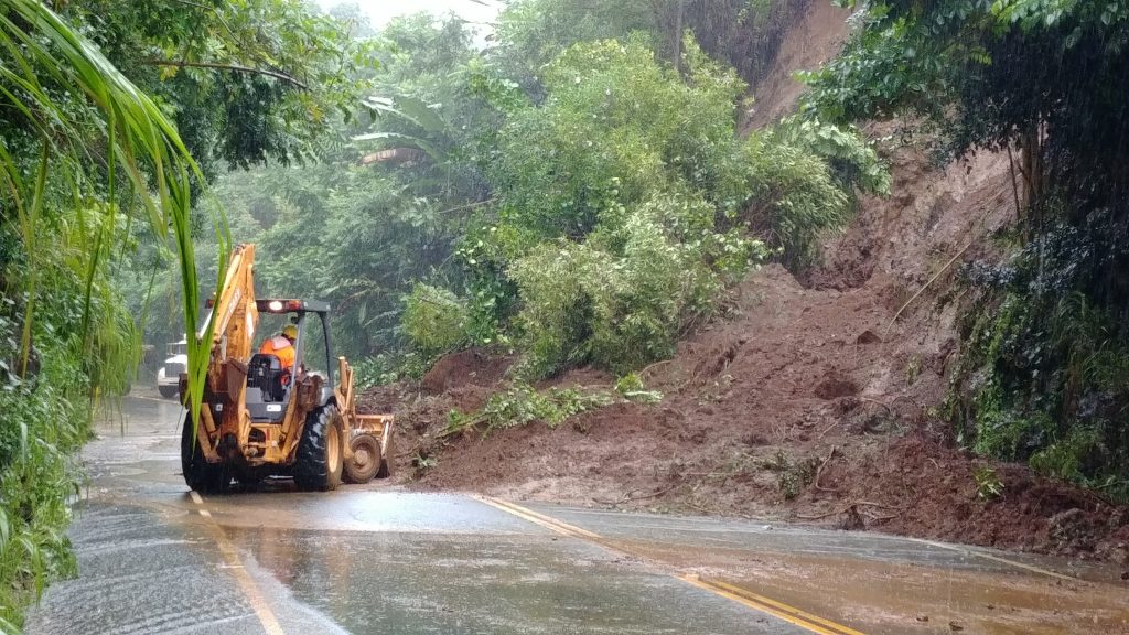
Mile marker 14.5 on Highway 19 near Kolekole and in Kolekole Gulch, Aug. 25, 2018, Hurricane Lane. PC: David Real
The Hawai‘i Department of Transportation (HDOT) provided an update on post storm assessments and response to ongoing weather situations on Hawai‘i Island as of Saturday, Aug. 25, 2018, at 5 p.m.
UDPATES IN RED
Airports
Airports statewide remain fully operational. Ticketed and confirmed passengers are reminded to check their flight status with their airline before heading to the airport. Please be patient and expect crowds at airports as airlines make up for earlier cancelations.
Harbors
With the removal of “Zulu” condition on Kaumalapau Harbor on Lanai at 11 a.m. Aug. 25, all commercial harbors statewide have been returned to “Hurricane Season Preparedness” status by the United States Coast Guard Captain of the Port. This means that shippers can resume operations with caution. Shippers should schedule arrivals in these ports through PortCall.com and should be aware of possible debris in the water. HDOT would like to send a big mahalo to the Captain of the Port Michael Long, USCG staff, Hawaii Harbor Users Group members and HDOT Harbors Division staff for ensuring minimal disruption to the state’s essential shipping operations.
Hawai‘i Island Highways
HDOT Highways Division Hawaii District staff conducted assessments and reported the following on state routes (unless otherwise stated, MM indicates mile marker):
Highway 11
10:58 a.m.: Both lanes on Highway 11 between the 82 and 83 mile markers in Ka‘ū are now OPEN.
MM8 – Stream debris on shoulder and in culvert.
MM 10 – Culvert blocked and needs clearing.
MM 11 (Sugar Mill Road/Kaupakuea Homestead Rd) – Water crossing road at culvert. No damage visible on initial inspection.
MM 15.5 – Pavement cracking observed on shoulder of Hilo bound lanes.
MM 18 to 20 – Potholes found on inbound and outbound lanes.
MM 21 – Potholes on Kau side of Hirano Store.
MM 30 – Restricted to one lane as crews work to clear trees and branches. Cracks and sinking pavement in the area.
MM 50 – Shoulder undermined on Pahala bound side of the road.
Highway 19
10:30 a.m.: Highway 19 along Bayfront Highway is now open.
MM 2.74 (Wailuku Br, Hāmākua side) – Road reopened.
MM 3.8 – Landslide blocking Hilo-bound lane.
MM 3.47, MM 6, MM 19, MM 21.76 – Road reopened.
MM 11 – Approximately 300’ stretch of road with large potholes.
MM 11.4 – Potholes observed.
Before MM 13 – Multiple landslides blocking shoulders of northbound lane; lane remains open.
MM 13 – Landslide in northbound lane and shoulder; northbound lane remains open. Landslide blocking southbound shoulder.
MM 13.5 (near Honomu Road) – Landslide blocking southbound shoulder.
MM 14 (near Kolekole Bridge) – Landslide blocking southbound shoulder.
MM 14.1 – Potholes observed.
MM 15.54 (Hakalau Bridge) – Mud on bridge deck. Road remains closed.
MM 28.5 (Ka‘awalii Gulch) – Rock scaling operations took place late Saturday afternoon. Additional scaling and debris removal continues late Saturday with intermittent traffic control.
Bayfront Highway remains closed due to flooding.
10:30 a.m.: Highway 19 along Bayfront Highway is open.
10:30 a.m.: Kamehameha Avenue from Ponahawai to the Ironworks Building remains closed.
Highway 130 at MM 2.8 – Tree and debris behind guardrail of Pahoa bound lanes.
Akoni Pule (Highway 270) at MM 25 – Debris after several landslides cleared and one lane reopened.
Daniel K. Inouye Highway (Saddle Road) between MM 8.9 to 11.1 – 2.3 miles of shoulder damaged or eroded and an estimated 15,000-20,000 cubic yards of material displaced by flood waters. Road reopened.
Kohala Mountain Road (Highway 250)
MM 13 – Road reopened.
MM 13.1 – Trees/branches down blocking shoulder.


