


11 PM: Hector Now Category 3
UPDATE: Aug. 7, 2018, 11 p.m.: Hector Now Category 3
At 11 p.m., the center of Hurricane Hector was located near latitude 16.5 North, longitude 152.2 West.

Hector is moving toward the west near 16 mph (26 km/h), and this same general motion is expected to continue through Thursday evening. On the latest forecast track, the center of Hector is expected to pass about 150 miles south of the Big Island during the day on Wednesday. Remember, the effects of a hurricane are far reaching and can extend well away from the center.
Maximum sustained winds are near 125 mph (205 km/h) with higher gusts. Hector is a category 3 hurricane on the Saffir-Simpson Hurricane Wind Scale. Some slight weakening is forecast during the
next couple of days. However, Hector will likely remain a powerful and dangerous hurricane through Thursday.
Hurricane-force winds extend outward up to 40 miles (65 km) from the center and tropical-storm-force winds extend outward up to 115 miles (185 km).
The estimated minimum central pressure is 956 mb (28.23 inches).
VIDEO: Big Island Now Meteorologist Malika Dudley; Central Pacific Hurricane Center Meteorologist Robert Ballard

UPDATE: Aug. 7, 2018, 8 p.m.: Central Pacific Hurricane Center Discusses Hector
At 8 p.m., the center of Hurricane Hector was located near latitude 16.6 north, longitude 151.6 west.
Hector is moving toward the west near 16 mph and this general motion is expected to continue through the next couple of days.
On the forecast track, the center of Hector is expected to pass 100 to 150 miles south of the Big Island during the day on Wednesday.
The effects of a hurricane are far-reaching and can extend well away from the center.
Maximum sustained winds are near 130 mph, with higher gusts. Hector is a Category 4 hurricane on the Saffir-Simpson Hurricane Wind Scale.
Some weakening is forecast during the next
couple of days.
Hurricane-force winds extend outward up to 40 miles from the center and tropical-storm-force winds extend outward up to 115 miles.
The estimated minimum central pressure is 28.12 inches.
UPDATE: Aug. 7, 2018, 7:30 p.m.: Mayor’s Office Releases Emergency Proclamation
Will Okabe, Acting Mayor of the County of Hawai‘i, released an emergency proclamation with Hurricane Hector closing in on the shores of the Big Island:
The National Weather Service has issued a Tropical Storm Warning for the island of Hawai‘i. A tropical storm warning is issued when there is a high probability of tropical storm force winds expected anytime within the next 36 hours.
As of 5 p.m. Tuesday, the center of Hurricane Hector was approximately 370 miles ESE of South Point at latitude 16.6 N and longitude 150.7 W, moving west at approximately 16 mph. Strongest sustained winds are estimated at 130 mph.
The following advisories have been issued by the Central Pacific Hurricane Center:
- Tropical storm force winds up to 73 mph are possible for the east and southeast sections of Hawaii Island, especially for the areas around South Point.
- High winds gusts are forecast through Wednesday and will affect the entire island, especially downslope areas.
- High Surf Warning up to 15 feet for east and southeast facing shores until 6 p.m. Wednesday.
The following public safety measures and recommendations are now in effect:
- High winds can cause extremely dangerous conditions due to flying debris, downed power lines, and blocked roads. These hazards can occur without advance warning.
- Be prepared for interruptions to utilities, including power outages.
- Secure loose objects in your yard and prepare your house for strong winds.
- Residents along the affected shores should be alert for high and dangerous surf conditions.
- It is important to remain calm, informed, and focused during an emergency.
- If in a place that is vulnerable to high wind, such as near large trees, a manufactured home, or on a boat, consider moving to a safer shelter before the onset of strong winds or flooding.
- More information on hurricane preparedness can be found online.
The following beach and road closures are in effect:
- Whittington, Punalu‘u, and Milolii Beach Parks are closed. All pavilion and camping permits for these three parks have been cancelled through Friday.
- South Point Road from the Kamaoa Road junction to South Point is open to local resident traffic only.
- Early voting sites at the Pāhoa Community Center and the Pahala Community Center will be closed Wednesday, Aug. 8.
UPDATE: Aug. 7, 2018, 6:30 p.m.: South Point Road Closed
The Hawai‘i Police Department reports that South Point Road is closed at Kamaoa Roadd intersection in Ka‘ū due to high winds. Local traffic is allowed only. The closure is expected to last through Wednesday, Aug. 8.
UPDATE: Aug. 7, 2018, 6 p.m.: Campgrounds Close
The DLNR Division of Forestry and Wildlife will close the Waimanu valley campground and Ainapo cabin Tuesday through Wednesday, for public safety due to the approach of Hurricane Hector. There may be flooding risk at Waimanu due to possible effects of a king tide, storm surge and heavy rainfall. Ainapo may face possible impacts due to tropical strength winds and rainfall.
The two locations will reopen Thursday, following assessment by forestry staff. All existing camping reservations will be cancelled and refunded for these two days. Persons holding camping permits for other dates may check status of these areas on the Na Ala Hele Trails and Access Program website at https://hawaiitrails.hawaii.gov/trails/#/.
Also posted on the Na Ala Hele trails website today is this advisory for all O‘ahu trails: “Please take caution before entering all forested areas as weather conditions may rapidly change. The Na Ala Hele Program strongly advises all users to check the current weather conditions before heading out. Please be aware that this advisory notice may turn into a warning. If weather conditions reach warning levels, all O‘ahu trails will be closed until further notice.”
On the forecast track the center of Hurricane Hector is expected to pass within 100 to 150 miles south of the Big Island on Wednesday. The effects of a hurricane are far-reaching and can extend well away from the center. Tropical storm force winds and locally damaging gusts are expected downslope from mountains, across elevated terrain, over headlands and through gaps.
Surf along east facing shores is building and is expected to peak tonight and into early Wednesday at 12 to 15 feet for the Big Island mainly for the Puna and Kau districts with six to 10 feet surf for
eastern Maui.
Rain bands in the northern fringe of Hurricane Hector will affect the Puna, Ka‘ū, North Hilo, and South Hilo Districts of the Big Island as the tropical cyclone passes south of the state on Wednesday and
Thursday. Rain showers may be locally heavy at times, particularly over east to southeast facing slopes.
UPDATE: Aug. 7, 2018, 5 p.m.: Tropical Storm Warning Issued for Hawai‘i County.
A Tropical Storm Warning means that tropical storm conditions are expected somewhere within the warning area.
At 5 p.m., the center of Hurricane Hector was located near latitude 16.6 North, longitude 150.7 West.
Hector is moving toward the west near 16 mph (26 km/h) and this general motion is expected to continue through the next couple of days.
On the forecast track, the center of Hector will pass 100 to 150 miles south of the Big Island during the day on Wednesday. Remember, the effects of a hurricane are far reaching and can extend well away from the center.

Maximum sustained winds are near 130 mph with higher gusts. Hector is a category 4 hurricane on the Saffir-Simpson Hurricane Wind Scale. Some weakening is forecast during the next 48
hours.
Hurricane-force winds extend outward up to 40 miles from the center and tropical-storm-force winds extend outward up to 115 miles.
The estimated minimum central pressure is 28.12 inches.
SURF: Swells generated by Hector are expected to reach southeast and east facing shores of the Big Island and eastern Maui late today, likely becoming large and dangerous by late tonight and
Wednesday.
WIND: Tropical storm conditions are expected across portions of the Big Island on Wednesday as the core of Hector passes to the south. The strongest winds are expected downslope from mountains,
across elevated terrain, over headlands and through gaps.

Hurricane Hector, Aug. 7, 2018, 11 a.m. PC: NOAA
https://www.facebook.com/BigIslandNow/videos/10157684540864867/?t=32
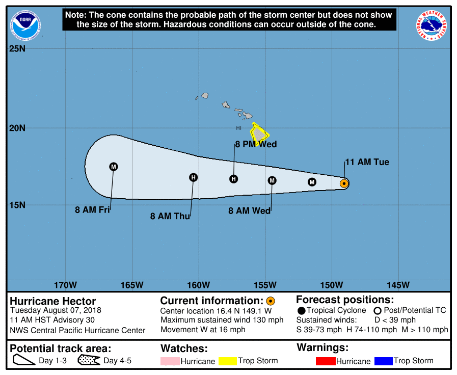
UPDATE: Aug. 7, 2018, Noon: Strong Category 4 Hector 450 Miles ESE of Hilo
As of 11:30 a.m., the center of Hurricane Hector was approximately 450 miles ESE of Hilo at latitude 16.4 N and longitude 149.1 W, moving west at approximately 16 miles per hour. Strongest sustained winds are estimated at 130 miles per hour with gusts up to 150 miles per hour.
High winds and high surf are expected tonight through Wednesday.
The following advisories have been issued by the Central Pacific Hurricane Center:
The County of Hawai‘i is under a Tropical Storm Watch. A tropical storm watch means damaging winds, damaging surf, and flooding rains are possible anytime within the next 48 hours.
As of noon, a High Surf Warning is issued for east and southeast facing shores.
The following public safety measures and recommendations are now in effect:
- Complete preparations before nightfall.
- Secure loose objects in your yard and prepare your house for strong winds.
- Boat owners should take measures to secure their vessels until the danger passes.
- Oceanfront residents are urged to be on alert for high and dangerous surf conditions.
- Be prepared as conditions can change rapidly!
More information on hurricane preparedness can be found online.
Whittington, Punalu‘u and Miloli‘i Beach Parks are closed. All pavilion and camping permits for these three parks have been cancelled through Friday.
UPDATE: Aug. 7, 2018, 9 a.m.: Strong Category 4 Hector 495 Miles ESE of Hilo

Hurricane Hector, Aug. 7, 2018, 9 a.m. PC: NOAA
As of 8 a.m., the center of Hurricane Hector was approximately 495 miles ESE of Hilo at latitude 16.3 N and longitude 148.5 W, moving west at approximately 16 miles per hour.
Hector’s strongest sustained winds are estimated at 130 miles per hour with gusts up to 150 miles per hour.
High winds and high surf are expected tonight through Wednesday.
The following advisories have been issues by the Central Pacific Hurricane Center:
The County of Hawai‘i is under a Tropical Storm Watch. A tropical storm watch means damaging winds, damaging surf and flooding rains are possible anytime within the next 48 hours.
The following public safety measures and recommendations are now in effect:
- Secure large objects in your yard and prepare your house for strong winds.
- Secure all boats and aircraft.
- Be prepared as conditions can change rapidly.
- More information on hurricane preparedness can be found here.
- Whittington, Punalu‘u, and Milolii Beach Parks are closed. All pavilion and camping permits for these three parks have been cancelled through Friday.

Hurricane Hector, Aug. 7, 2018, 7 a.m. PC: NOAA
ORIGINAL POST: 7:52 a.m.: Strong Category 4 Hector 540 Miles ESE of Hilo
A Tropical Storm Watch is in effect for Big Island interior, summits, north, east and south, including Kohala and Kona.
Hurricane Hector, with 130 mph winds, is about 540 miles east-southeast of Hilo.
Hurricane Hector is expected to pass approximately 165 miles south of the Big Island on Wednesday, Aug. 8, 2018.
However, only a small deviation to the north of the forecast track could bring tropical storm force winds to the Big Island later tonight or on Wednesday.
Surf along east-facing shores is already building and will peak later today and tonight, at 12 to 15 feet for the Big Island, mainly for the Puna and Ka‘ū Districts.
Enhanced rainfall from deep tropical moisture surrounding Hector will affect the Puna and Ka‘ū Districts of the Big Island as the hurricane passes by south of the state on Wednesday and Thursday.
Rain showers may be locally heavy at times, particularly over east to southeast around midnight, or sooner if conditions warrant.
Sponsored Content


