4 PM: New Map Released, Southern Edge of Flow Stalls
This news story will be updated throughout the day as new information becomes available and new articles will be added to the website’s “News” section. Previous information about ongoing events can be found in Big Island Now’s “Volcano Blog” section.
KĪLAUEA SUMMIT LIVESTREAM LINK
CLICK HERE FOR INTERACTIVE LAVA MAP FOR JULY 16, 2018
Monday, July 16, 2018, 4 p.m.
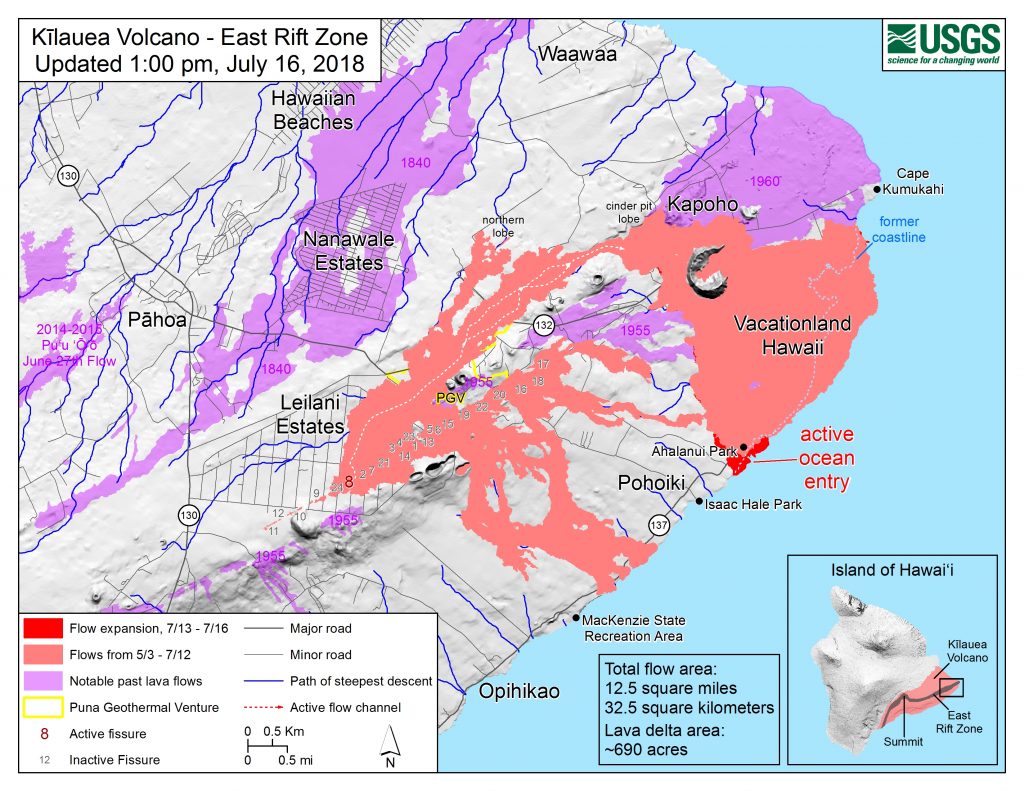
Map as of 1 p.m. July 16, 2018.
Given the dynamic nature of Kīlauea’s lower East Rift Zone eruption, with changing vent locations, fissures starting and stopping, and varying rates of lava effusion, map details shown here are accurate as of the date/time noted. Shaded purple areas indicate lava flows erupted in 1840, 1955, 1960 and 2014-2015.
The Hawaiian Volcano Observatory reports that Fissure 8 continues to erupt lava into the perched channel heading northeast from the vent toward Kapoho. The southern edge of the flow has stalled about 0.6 miles from Isaac Hale Park, and lava continues to ooze into the ocean near Ahalanui. Explosions were reported from the ocean entry this morning, with at least one being quite strong. No other fissures are active.
The following policies remain in effect:
- Do not access the active flow field due to extreme hazard. Be aware that spill overs of the flow channel and other breakouts are possible on the active flow field.
- The ocean entry continues to produce a “laze” plume. Take precautions and stay out of the plume to avoid exposure to hydrochloric acid and glass particles, which can irritate the skin, eyes, and lungs.
Disaster assistance is available island-wide to individuals and businesses in Hawai‘i County that have been affected by the Kīlauea eruption.
- The Disaster Recovery Center, located at the Kea‘au High School Gym, is open daily from 8am to 6pm weekdays and 8 a.m. to 4 p.m. on weekends (closed this Sunday, July 22). If you need a ride, buses run between the two shelters and the Disaster Recovery Center.
- Placards are available at the Civil Defense office located at 920 Ululani St. in Hilo.
Monday, July 16, 2018, 11:47 a.m.
Hawaiian Volcanoes Observatory reports a collapse/explosive event with energy equal to a 5.4-magnitude earthquake has occurred at Halema‘uma‘u Crater at 11:43 a.m.
The Pacific Tsunami Warning Center reports there is no tsunami threat to the Island of Hawai‘i.
THE EVENT IS LIKELY ASSOCIATED WITH A SUMMIT ERUPTION.
ITS PRELIMINARY PARAMETERS ARE:
ORIGIN TIME – 1143 AM HST 16 JUL 2018
COORDINATES – 19.4 NORTH 155.3 WEST
LOCATION – IN THE SUMMIT REGION OF KILAUEA VOLCANO
MAGNITUDE – 5.4
Due to the volcanic activity, the following is provided for your awareness:
- Residents in the area affected by earthquakes are advised to monitor utility connections of gas, electricity, and water after earthquakes.
- When driving be on the lookout for cracks in roadways.
- If ash is observed stay indoors or seek cover.
9:15 a.m.: 12 Injured in Lava Bomb Explosion
For updates on this incident, click here.
The Hawai‘i County Fire Department has confirmed that a lava tour boat returned to Wailoa Harbor in Hilo around 7 a.m. with 12 injured passengers after the tour boat operated by Shane Turpin was involved in an ocean entry lava explosion.
The fire department reported that a lava bomb punctured the roof of the boat, leaving a large hole.
One of the railings of the boat was also damaged.
Of the 12 injured passengers, three were taken by ambulance to Hilo Medical Center. Two passengers were reported to be in stable condition.
One of the injured passengers, a woman in her 20s, was in serious condition with a fractured femur.
The remaining nine passengers drove themselves to the hospital with superficial injuries, the fire department reported.
The exact location of the incident is not yet clear, nor is the precise time of the incident.
A volcanic lava bomb is a mass of molten rock (tephra) larger than 64 mm (2.5 inches) in diameter, formed when a volcano ejects viscous fragments of lava during an eruption. They cool into solid fragments before they reach the ground.
8:21 a.m.: VIDEO: Explosion at Ocean Entry
Unofficial reports indicate that the Hawaiʻi County Fire Department and medical personnel are responding to Suisan Harbor in Hilo. Tour boat operator Ikaika Marzo provided video of a lava explosion near the Kapoho ocean entry this morning, that sent lava pyroclasts flying into the air, landing on a tour boat operated by Shane Turpin.
Eyewitnesses reported that it ripped through the tour boat roof, injuring several passengers and crew members.
More information will be published as soon as officials make it available.
https://www.facebook.com/ikaika.marzo/videos/1887564864629374/?t=16
8:14 a.m.: VIDEO: Lightning, Explosion in Ocean Entry Plume
https://www.facebook.com/ikaika.marzo/videos/1887566601295867/?t=9
Posted by Ikaika Marzo.
6 a.m.: Fissure 8 Flow Continues Into Ocean Near Ahalanui

Laze plume rises where lava pours into the sea on the south margin of the fissure 8 flow. This southern boundary did not change location appreciably in the past day, remaining about 900 m (0.56 mi) from the boat ramp at Isaac Hale Park. PC: USGS
Hawaiian Volcano Observatory reports that Fissure 8 continues to erupt lava into the channel heading northeast toward Kapoho into the ocean near Ahalanui.
The following policies remain in effect:
- Be aware that spill overs of the channel and other breakouts are possible on the active flow field.
- Do not access the active flow field due to extreme hazard.
- Disaster assistance is available island-wide to individuals and businesses in Hawaii County that have been affected by the Kilauea eruption.
The Disaster Recovery Center is open daily from 8 a.m. to 6 p.m. weekdays and 8 a.m. to 4 p.m. weekends, and is located at the Kea‘au High School Gym. If you need a ride, buses run between the two shelters and the Disaster Recovery Center.
Placards are available from today at the Civil Defense office located at 920 Ululani Street in Hilo.


