

New Maps & Photos of East Rift Zone
The U.S. Geological Survey released this updated map and photos of the East Rift Zone on Tuesday, June 19, 2018.
Map as of 1 p.m., June 19, 2018.

Click to enlarge
Given the dynamic nature of Kīlauea’s lower East Rift Zone eruption, with changing vent locations, fissures starting and stopping, and varying rates of lava effusion, map details shown here are accurate as of the date/time noted. Shaded purple areas indicate lava flows erupted in 1840, 1955, 1960 and 2014-2015.
Geology field crews on the ground near the Kīlauea’s fissure 8 midday on June 19, 2018 observed a still-vigorous channelized lava flow being fed by lava fountains at the vent. Standing waves are visible within the channel. Cascades/rapids are visible near the base of the cone, which is an estimated 50 m (164 ft) high. The maximum flow velocity in the channel is 17 mph.
Ground view and overflight June 19, Fissure 8 from vent to sea, Kīlauea Volcano
ARTICLE CONTINUES BELOW ADARTICLE CONTINUES BELOW ADGeology field crews on the ground near the Kīlauea's fissure 8 midday on June 19, 2018 observed a still-vigorous channelized lava flow being fed by lava fountains at the vent. Standing waves are visible within the channel. Cascades/rapids are visible near the base of the cone, which is an estimated 50 m (164 ft) high. The maximum flow velocity in the channel is 7.7 m/s (17 mph). During the morning overflight, several small overflows could be seen along the channel margins. The flow of lava is more rapid in the center of the channel and decreases in speed toward the margins where friction with the channel walls increases.The lava flow forks as it nears the ocean, creating two ocean entry points.#KilaueaErupts #KilaueaEruption #LERZ #volcanoes #USGS
ADVERTISEMENT ARTICLE CONTINUES BELOW AD
Posted by USGS Volcanoes on Tuesday, June 19, 2018
During the morning overflight, several small overflows could be seen along the channel margins. The flow of lava is more rapid in the center of the channel and decreases in speed toward the margins where friction with the channel walls increases.
The lava flow forks as it nears the ocean, creating two ocean entry points.
Satellite radar shows continued slumping of Halema‘uma‘u rim
This animated GIF shows a sequence of radar amplitude images that were acquired by the Agenzia Spaziale Italiana CosmoSkyMed satellite system.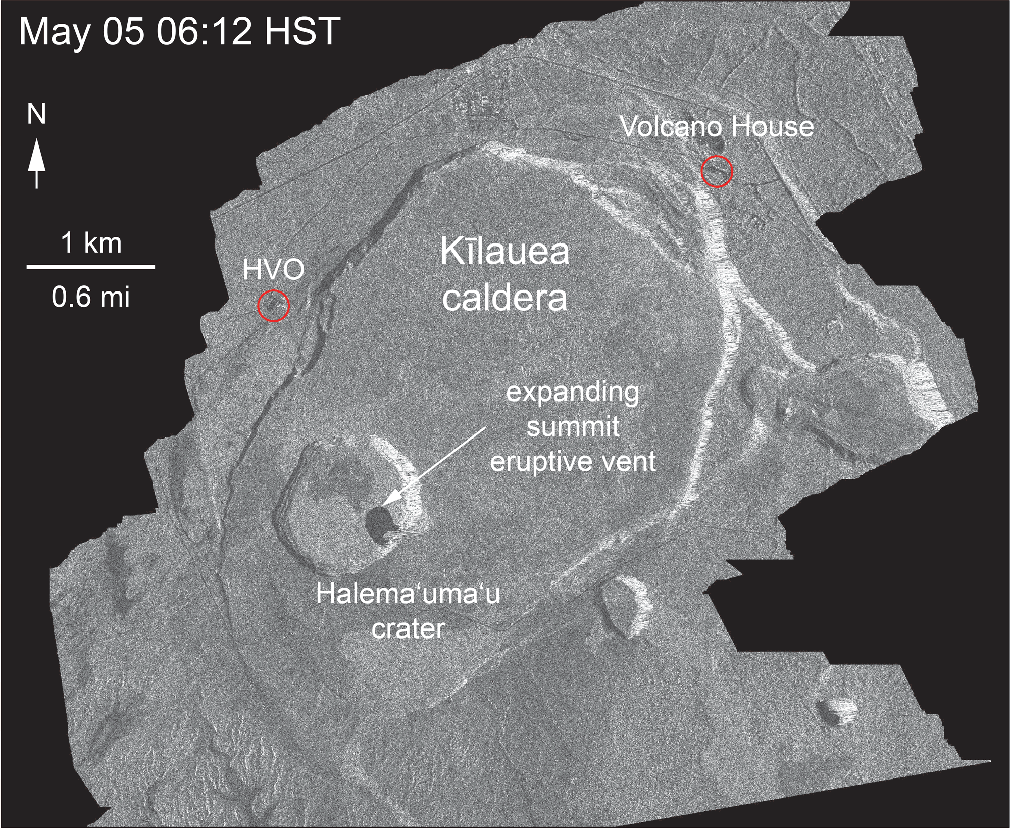
The images illustrate changes to the caldera area of Kīlauea Volcano that occurred between May 5 and June 18 at about 6 a.m. The satellite transmits a radar signal at the surface and measures the strength of the return, with bright areas indicating a strong return and dark areas a weak return. Strong returns indicate rough surfaces or slopes that point back at the radar, while weak returns come from smooth surfaces or slopes angled away from the radar.
Over time, expansion of the summit eruptive vent within Halema‘uma‘u crater and the widening of Halema‘uma‘u itself are clear. The last five images in the sequence, from May 29 to June 18, show the development of several cracks outside Halema‘uma‘u (also seen in recent UAS footage of the crater) and inward slumping of a large portion of the western, southwestern, and northern crater rim. Much of this motion appears to be coincident with the small explosions from the summit that have taken place on a near daily basis over the past three weeks. We expect this slumping to continue as long as the explosions and overall subsidence persist.
Fissure 8 increased in vigor overnight
Fissure 8 vigor increased overnight June 18 and 19 with lava fountains reaching up to 200 feet. Spatter built up the cone to the east and into the channel.

In this photograph, spatter lands on the east cone and flows downward.
Fissure 8 lava fountains obscured by a longer exposure photograph taken early morning on June 18. The incandescent spots along a horizontal line mark the edge of the lava channel.

A tongue of incandescent lava leads down to the right – a small overflow from the channel margin.
The northern channel margin of the fissure 8 lava flow. Small hill in the distance is the site of our PGcam.

These flows are building up the channel margins and making the levees more robust.
Overflows from the channel can be seen producing shiny black to silver pahoehoe flows (incandescent red breakout visible in center of photo).
Fissure 8 cone, lava fountain, and channelized lava flow on the morning overflight – June 19 at about 6:10 a.m.

Overflows are sluggish and move slowly downslope as they build up the levees.
The lava channel is very full with many small overflows visible on the channel margins.
June 18 summit overflight photos show Halema‘uma‘u with HVO for perspective
During the helicopter overflight on June 18, crews captured this image of the growing Halema‘uma‘u crater viewed to the southeast.

The estimated total volume loss is about 260 million cubic meters as of June 15.
With HVO and Jagger Museum sitting on the caldera rim (right side, middle where the road bends to the left) it is easier to comprehend the scale of subsidence at the summit. The estimated total volume loss is about 260 million cubic meters as of June 15.
Halema‘uma‘u viewed toward the west during the June 18 helicopter overflight.

HVO and Jaggar Museum can barely be seen on the caldera rim in the upper right of the photograph.
Sponsored Content


