

6 p.m.: Emissions Into Interior of Big Island
This news story will be updated throughout the day as new information becomes available and new articles will be added to the website’s “News” section. Previous information about ongoing events can be found in Big Island Now’s “Volcano Blog” section
CLICK HERE FOR JUNE 18 INTERACTIVE MAP
KĪLAUEA SUMMIT LIVESTREAM LINK
6 p.m.: Emissions Move Into Interior of Big Island
Hawaiian Volcano Observatory reports that Fissure 8 continues to erupt with a full channel flowing to the ocean at multiple points. Fissure 15 has mild spattering and Fissure 6 is oozing.
The National Weather Service says light winds overnight will push emissions into the interior of the Big Island, including Hilo, northern and western parts of the Big Island. Trade winds are expected to build by Thursday.
The following resources are available to residents of Hawai‘i County who suffered damage or losses from the Kīlauea volcanic eruption and recent earthquakes:
- A FEMA Disaster Recovery Center is open daily from 8 a.m. to 8 p.m., and is located at the Kea‘au High School Gym
- The Hawai‘i Dept. of Health will be holding Volcanic Ash and Vog Community Meetings tomorrow at Konawaena Elementary School in Kealakekua beginning at 5 p.m. and Thursday at Waikoloa Elementary & Middle School Cafeteria beginning at 6 p.m.
- Tropic Care 2018 continues tomorrow with free medical, dental and eye care at Kea‘au High School from 8 a.m. until 5 p.m.
5 p.m.: Fissures 6, 15 & 16 Oozing Lava
The eruption in the lower East Rift Zone (LERZ) continues with little change.

Live Panorama of Lower East Rift Zone Camera from Lower East Rift Zone [PGcam]
last updated June 19, 2018, at 4:50 p.m.
Fissure 8 continues to feed lava into the well-established channel that flows to the ocean at Kapoho. Small overflows were observed on the north side of the channel near Pohoiki Road overnight and this morning, but stalled in the afternoon. Another small, sluggish overflow along a section of Luana Street is advancing northwest. Fissure 6, 15 and16 are oozing lava and fume. The size and shape of the flow field is virtually unchanged since the morning of Monday, June 18, with the exception of an additional 28 acres, mostly at the southwest margin of the flow in the coastal area.

Click to enlarge
Pele’s Hair and other lightweight volcanic glass fragments from the lava fountain at Fissure 8 continue to fall downwind of the fissure, dusting the ground within a few hundred yards of the vent. High winds may waft lighter particles to greater distances. Residents are urged to minimize exposure to these volcanic particles, which can cause skin and eye irritation similar to volcanic ash.
Geology field crews on the ground near the Kīlauea’s fissure 8 midday on June 19, 2018, observed a still-vigorous channelized lava flow being fed by lava fountains at the vent. Standing waves are visible within the channel. Cascades/rapids are visible near the base of the cone, which is an estimated 164 feet high. The maximum flow velocity in the channel is 17 mph.
During the morning overflight, several small overflows could be seen along the channel margins. The flow of lava is more rapid in the center of the channel and decreases in speed toward the margins where friction with the channel walls increases. The lava flow forks as it nears the ocean, creating two ocean entry points.
2:30 p.m.: No Tsunami Threat
The Pacific Tsunami Warning Center reports a 4.6-magnitude earthquake occurred at 2:24 p.m. centered in the vicinity of the south side of Kīlauea Volcano.
This earthquake was not large enough to cause a tsunami for the Island of Hawai‘i.

June 18, 2018: Kīlauea Volcano’s lower East Rift Zone. Fissure 8 lava flows in an open channel all the way to the ocean. Kapoho Crater is the vegetated hill on the right side of the photograph. Ocean entry plume seen in the distance. PC: USGS HVO
Tuesday, June 19, 2018, noon:
Fissure 8 continues to erupt with a full channel flowing to the ocean with two ocean entries.
Hawaiian Volcano Observatory also reports little splatter from Fissure 6.
The National Weather Service reports that after nightfall today, winds will push volcanic emissions into the interior of the Big Island, including over Hilo, northern parts of the island and wrapping around to the west.
SO2 and Pele’s Hair may become an issue in Pāhoa and possibly into the Hawaiian Acres area.
Trade winds are expected to build by Thursday.
As of today 894 people have registered with the Federal Emergency Management Agency for assistance either on line or at the Disaster Recovery Center or DRC. The DRC is one of many resources that continue to be available to residents of Hawai‘i County who suffered damage or losses from the Kilauea volcanic eruption and recent earthquakes
The DRC at the Kea‘au High School Gym is open daily from 8 a.m. to 8 p.m.
Tonight’s regularly scheduled community meeting at the Pāhoa High School Cafeteria at 5 p.m. will include representatives from the Small Business Administration and FEMA. An American Sign Language interpreter will be on-hand.
The Hawai’i Department of Health will hold Volcanic Ash and Vog Community Meetings tomorrow and on Thursday.
Wednesday’s is at Konawena Elementary School in Kealakekua beginning at 5 p.m.
Thursday’s is at Waikaloa Elementary & Middle School Cafeteria beginning at 6 p.m.
Tropic Care 2018 continues today and tomorrow with free medical, dental and eye care at Keaau High School from 8 a.m. until 5 p.m.
6 a.m.: 817 Registered With FEMA
Fissure 8 continues to erupt with a full channel and one major ocean entry at Kapoho. HVO continues to monitor three other fissures that are weakly active. There is no immediate threat at this time.
The National Weather Service reports that today through Thursday light winds are expected to push vog into the saddle and interior areas of the Big Island. Trade winds are predicted to return on Friday.
Numerous resources continue to be available to residents of Hawai‘i County who suffered damage or losses from the Kīlauea volcanic eruption and recent earthquakes. As of yesterday afternoon, 817 people have registered with the Federal Emergency Management Agency for assistance either on line or at the Disaster Recovery Center or DRC.
The DRC at the Kea‘au High School Gym is open daily from 8 a.m. to 8 p.m.
Tropic Care 2018 continues today and tomorrow with free medical, dental and eye care at Kea‘au High School from 8 a.m. until 5 p.m. Additional screening days are scheduled for the coming weeks.
There will be a community meeting at the Pāhoa High School Cafeteria today at 5 p.m.
An American Sign Language interpreter will be on-hand.
5:33 a.m.: Kīlauea Gas & Ash Emission
At 5:05 a.m., another gas and ash emission from a small subsurface explosion occurred at Kīlauea’s summit, producing a plume that was blown downwind at about 1,000 feet above ground level.
VIDEO: On June 18, 2018, at 6:13 a.m., a seismic event occurred at Halema‘uma‘u that produced a relatively ash-poor gas plume that rose about 1,600 feet above the crater. The activity was captured by the Halema‘uma‘u Wide Angle webcam located in the USGS–Hawaiian Volcano Observatory Observation Tower. The plume dissipated quickly.
Satellite radar shows continued slumping of Halema‘uma‘u rim
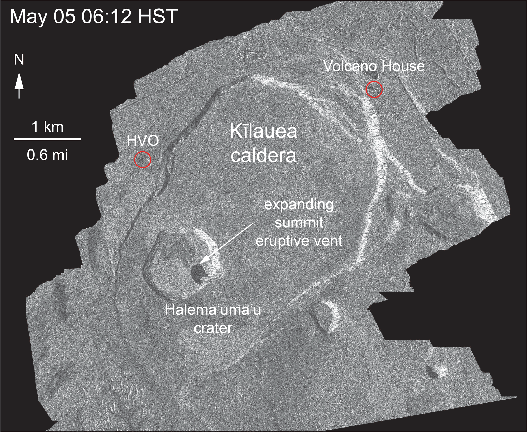 ANIMATION: This animated GIF shows a sequence of radar amplitude images that were acquired by the Agenzia Spaziale Italiana CosmoSkyMed satellite system. The images illustrate changes to the caldera area of Kīlauea Volcano that occurred between May 5 and June 18 at about 6 a.m. HST. The satellite transmits a radar signal at the surface and measures the strength of the return, with bright areas indicating a strong return and dark areas a weak return. Strong returns indicate rough surfaces or slopes that point back at the radar, while weak returns come from smooth surfaces or slopes angled away from the radar. Over time, expansion of the summit eruptive vent within Halema‘uma‘u crater and the widening of Halema‘uma‘u itself are clear. The last five images in the sequence, from May 29-June 18, show the development of several cracks outside Halema‘uma‘u (also seen in recent UAS footage of the crater) and inward slumping of a large portion of the western, southwestern, and northern crater rim. Much of this motion appears to be coincident with the small explosions from the summit that have taken place on a near daily basis over the past 3 weeks. We expect this slumping to continue as long as the explosions and overall subsidence persist.
Monday, June 18, 2018, 11 p.m.: Kīlauea Media Briefing
10:30 p.m.: HVO STATUS REPORT
Kīlauea Volcano Lower East Rift Zone

Kīlauea Lower East Rift Zone lava flows and fissures, June 18, a.m. Given the dynamic nature of Kīlauea’s lower East Rift Zone eruption, with changing vent locations, fissures starting and stopping, and varying rates of lava effusion, map details shown here are accurate as of the date/time noted. Shaded purple areas indicate lava flows erupted in 1840, 1955, 1960, and 2014-2015. Click to enlarge.
The eruption from vents in the lower East Rift Zone (LERZ) continues with little change.
Fissure 8 fountains continue to feed lava into the well-established channel that flows to the ocean at Kapoho. The flow front at the coast is about 1.5 miles across, but lava pours into the ocean at a single entry, creating a large laze plume. Fissures 16/18 continue to ooze lava and Fissure 6 is mildly spattering. The size and shape of the flow field is virtually unchanged upslope, but an additional 120 acres have been added to the western margin of the flow in the coastal area since last Friday, June 15.
Pele’s Hair and other lightweight volcanic glass fragments from the lava fountain at Fissure 8 continue to fall downwind of the fissure, dusting the ground within a few hundred meters (yards) of the vent. High winds may waft lighter particles to greater distances. Residents are urged to minimize exposure to these volcanic particles, which can cause skin and eye irritation similar to volcanic ash.
HVO field crews are on site tracking the fountains, lava flows, and spattering from Fissure 8 as conditions allow and are reporting information to Hawaii County Civil Defense. Observations are also collected on a daily basis from cracks in the area of Highway 130; no changes in temperature, crack width, or gas emissions have been noted for several days.
Volcanic gas emissions remain very high from Fissure 8 eruptions. Winds are expected to bring VOG to the central, south, and western parts of the Island of Hawaii. VOG information can be found at https://vog.ivhhn.org/.
The ocean entry is a hazardous area. Venturing too close to an ocean entry on land or the ocean exposes you to flying debris from sudden explosive interaction between lava and water. Also, the lava delta is unstable because it is built on unconsolidated lava fragments and sand. This loose material can easily be eroded away by surf, causing the new land to become unsupported and slide into the sea. Additionally, the interaction of lava with the ocean creates “laze,” a corrosive seawater plume laden with hydrochloric acid and fine volcanic particles that can irritate the skin, eyes and lungs.
Magma continues to be supplied to the Lower East Rift Zone. Seismicity remains relatively low in the area with numerous small magnitude earthquakes and low amplitude background tremor. Higher amplitude tremor is occasionally being recorded on seismic stations close to the ocean entry.
Additional ground cracking and outbreaks of lava in the area of the active fissures are possible. Residents downslope of the region of fissures should heed all Hawai‘i County Civil Defense messages and warnings.
Kīlauea Volcano Summit
After this morning’s seismic event and gas emission, the number of earthquakes dropped abruptly but have been increasing through the day reaching about 30 to 35 events per hour by 10 p.m.. Inward slumping of the rim and walls of Halemaʻumaʻu continues in response to ongoing subsidence at the summit.
Sulfur dioxide emissions from the volcano’s summit have dropped to levels that are about half those measured prior to the onset of the current episode of eruptive activity. This gas and minor amounts of ash are being transported downwind, with small bursts of ash and gas accompanying intermittent explosive activity.
For forecasts of where ash would fall under forecast wind conditions, consult the Ash3D model output here.
Information on volcanic ash hazards and how to prepare for ash fall maybe found at http://www.ivhhn.org/information#ash (health impacts) OR https://volcanoes.usgs.gov/volcanic_ash/ (other impacts).
Sponsored Content


