

6 PM: 817 People Register for FEMA Assistance So Far
This news story will be updated throughout the day as new information becomes available and new articles will be added to the website’s “News” section. Previous information about ongoing events can be found in Big Island Now’s “Volcano Blog” section
CLICK HERE FOR JUNE 18 INTERACTIVE MAP
KĪLAUEA SUMMIT LIVESTREAM LINK
VIDEO: The well-channelized flow from Fissure 8 is a nearly 8-mile-long river of lava from Leilani Estates to the ocean in Kapoho. Seen here from the Bryson Cinder Quarry on Government Beach Road on June 17, 2018, at 7p.m. VC: Scott Cate.
Monday, June 18, 2018, 6 p.m.: 817 People Register for FEMA Assistance So Far
Fissure 8 continues to erupt with a full channel and one major ocean entry at Kapoho. HVO continues to monitor three other fissures that are weakly active. There is no immediate threat at this time.
The National Weather Service reports that Tuesday through Thursday northwest winds are expected to push vog into the saddle and interior areas of the Big Island. Trade winds are predicted to return on Friday.
Numerous resources continue to be available to residents of Hawai‘i County who suffered damage or losses from the Kīlauea volcanic eruption and recent earthquakes. As of Monday, June 18, 2018, 817 people have registered with the Federal Emergency Management Agency for assistance either on line or at the Disaster Recovery Center or DRC.
The DRC, is open daily from 8 a.m. to 8 p.m., and is located at the Kea‘au High School Gym.
Tropic Care 2018 continues Tuesday and Wednesday with free medical, dental and eye care at Kea‘au High School from 8 a.m. until 5 p.m. Additional screening days are scheduled for the coming weeks.
There will be a community meeting at the Pāhoa High School Cafeteria tomorrow at 5 p.m. An American Sign Language interpreter will be on hand.
Monday, June 18, 2018, 3:45 p.m.: HVO UPDATE: Fissure 6 Shows Some Incandescence
Kīlauea Volcano Lower East Rift Zone
The eruption from vents in the lower East Rift Zone (LERZ) continues with little change.
Fissure 8 fountains, encircled by a spatter cone, continue to feed lava into the well-established channel that flows to the ocean at Kapoho. About midday, minor amounts of lava spilled over the channel levees but did not advance very far. The lava flow front is rather broad at the coast and lava is entering the ocean at a single point with an upwelling area offshore and with laze blown onshore. Fissures 16/18 continue to ooze lava and Fissure 6 shows some incandescence (visible in PGcam to the left of Fissure 8 most nights, see photo below) and mild spattering. The flow field is relatively stable with little change to its size and shape for the past few days.

Panorama from Lower East Rift Zone camera of Lower East Rift Zone [PGcam], last updated June 18, 2018, 5:05 p.m. PC: USGS HVO
Pele’s Hair and other lightweight volcanic glass fragments from the lava fountain at Fissure 8 continue to fall downwind of the fissure, dusting the ground within a few hundred meters (yards) of the vent. High winds may waft lighter particles to greater distances. Residents are urged to minimize exposure to these volcanic particles, which can cause skin and eye irritation similar to volcanic ash.
HVO field crews are on site tracking the fountains, lava flows, and spattering from Fissure 8 as conditions allow and are reporting information to Hawai‘i County Civil Defense. Observations are also collected on a daily basis from cracks in the area of Highway 130; no changes in temperature, crack width, or gas emissions have been noted for several days.
The most recent map of lava flows can be found online.
Volcanic gas emissions remain very high from Fissure 8 eruptions. Winds are expected to bring VOG to the central, south, and western parts of the Island of Hawaii. VOG information can be found at https://vog.ivhhn.org/.
The ocean entry is a hazardous area. Venturing too close to an ocean entry on land or the ocean exposes you to flying debris from sudden explosive interaction between lava and water. Also, the lava delta is unstable because it is built on unconsolidated lava fragments and sand. This loose material can easily be eroded away by surf, causing the new land to become unsupported and slide into the sea. Additionally, the interaction of lava with the ocean creates “laze,” a corrosive seawater plume laden with hydrochloric acid and fine volcanic particles that can irritate the skin, eyes and lungs.
Magma continues to be supplied to the Lower East Rift Zone. Seismicity remains relatively low in the area with numerous small magnitude earthquakes and low amplitude background tremor. Higher amplitude tremor is occasionally being recorded on seismic stations close to the ocean entry.
Additional ground cracking and outbreaks of lava in the area of the active fissures are possible. Residents downslope of the region of fissures should heed all Hawai‘i County Civil Defense messages and warnings.
Kīlauea Volcano Summit
After this morning’s seismic event and gas emission, the number of earthquakes dropped abruptly and have been increasing through the day. Inward slumping of the rim and walls of Halemaʻumaʻu continues in response to ongoing subsidence at the summit.
Sulfur dioxide emissions from the volcano’s summit have dropped to levels that are about half those measured prior to the onset of the current episode of eruptive activity. This gas and minor amounts of ash are being transported downwind, with small bursts of ash and gas accompanying intermittent explosive activity.
For forecasts of where ash would fall under forecast wind conditions, consult the Ash3D model output here.
Information on volcanic ash hazards and how to prepare for ash fall maybe found at http://www.ivhhn.org/information#ash (health impacts) OR https://volcanoes.usgs.gov/volcanic_ash/ (other impacts).
9:24 a.m.: HVO: Over 500 Earthquakes Produced in Less Than 24 Hours
Current Volcano Alert Level: WARNING
Current Aviation Color Code: RED
Kīlauea Volcano Lower East Rift Zone
The eruption from vents in the lower East Rift Zone (LERZ) continues with little change.
Fissure 8 fountains, encircled by a spatter cone, continue to feed lava into the well-established channel that flows to the ocean at Kapoho. Occasionally, minor amounts of lava briefly spill over the channel levees. The lava flow is rather broad at the coast and lava is entering the ocean at a single point with an upwelling area offshore and with laze blown onshore.
Fissures 16/18 continue to ooze lava and Fissure 6 shows some incandescence (visible in PGcam to the left of Fissure 8 most nights) and mild spattering during our overflights. The flow field is relatively stable with little change to its size and shape for the past few days.
Pele’s Hair and other lightweight volcanic glass fragments from the lava fountain at Fissure 8 continue to fall downwind of the fissure, dusting the ground within a few hundred meters (yards) of the vent. High winds may waft lighter particles to greater distances. Residents are urged to minimize exposure to these volcanic particles, which can cause skin and eye irritation similar to volcanic ash.

This thermal map shows the fissure system and lava flows as of 6 am on Saturday, June 16. USGS HVO map
MAP: This thermal map shows the fissure system and lava flows as of 6 am on Saturday, June 16. The fountain at Fissure 8 remains active, with the lava flow entering the ocean at Kapoho. Very small, weak lava flows have been active recently near the Fissure 16/18 area. The black and white area is the extent of the thermal map. Temperature in the thermal image is displayed as gray-scale values, with the brightest pixels indicating the hottest areas. The thermal map was constructed by stitching many overlapping oblique thermal images collected by a handheld thermal camera during a helicopter overflight of the flow field. The base is a copyrighted color satellite image (used with permission) provided by Digital Globe.
HVO field crews are on site tracking the fountains, lava flows, and spattering from Fissure 8 as conditions allow and are reporting information to Hawaii County Civil Defense. Observations are also collected on a daily basis from cracks in the area of Highway 130; no changes in temperature, crack width, or gas emissions have been noted for several days.
Volcanic gas emissions remain very high from Fissure 8 eruptions. Winds are expected to bring vog to the central, south, and western parts of the Island of Hawai‘i. Vog information can be found at https://vog.ivhhn.org/.
The ocean entry is a hazardous area. Venturing too close to an ocean entry on land or the ocean exposes you to flying debris from sudden explosive interaction between lava and water. Also, the lava delta is unstable because it is built on unconsolidated lava fragments and sand. This loose material can easily be eroded away by surf, causing the new land to become unsupported and slide into the sea. Additionally, the interaction of lava with the ocean creates “laze,” a corrosive seawater plume laden with hydrochloric acid and fine volcanic particles that can irritate the skin, eyes and lungs.
Magma continues to be supplied to the Lower East Rift Zone. Seismicity remains relatively low in the area with numerous small magnitude earthquakes and low amplitude background tremor. Higher amplitude tremor is occasionally being recorded on seismic stations close to the ocean entry.
Additional ground cracking and outbreaks of lava in the area of the active fissures are possible. Residents downslope of the region of fissures should heed all Hawai‘i County Civil Defense messages and warnings.
Kīlauea Volcano Summit
After over 500 earthquakes (24 of which were strong than magnitude-3.0) since noon Sunday beneath the summit of Kīlauea volcano, nearby residents felt a large earthquake and may have heard a roaring followed by a low gas plume emerging from Halema‘uma‘u crater at 6:13 a.m. The plume was blown downwind at about 1,000 feet above ground level. Seismicity abruptly dropped as it commonly does after these events and we expect it to begin increasing during the day. Inward slumping of the rim and walls of Halemaʻumaʻu continues in response to ongoing subsidence at the summit.
Sulfur dioxide emissions from the volcano’s summit have dropped to levels that are about half those measured prior to the onset of the current episode of eruptive activity. This gas and minor amounts of ash are being transported downwind, with small bursts of ash and gas accompanying intermittent explosive activity.
For forecasts of where ash would fall under forecast wind conditions, consult the Ash3D model output here.
Information on volcanic ash hazards and how to prepare for ash fall maybe found at http://www.ivhhn.org/information#ash (health impacts) OR https://volcanoes.usgs.gov/volcanic_ash/ (other impacts).
6 a.m.: No Tsunami Generated From 5.3-M Kïlauea Quake
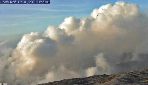
Kīlauea Caldera from HVO Observation Tower, June 18, 2018, 6:20 a.m.
The Pacific Tsunami Warning Center reports an explosion at the Kïlauea Summit.
The energy is like a 5.3 magnitude earthquake. No tsunami is expected.
Hawaiian Volcano Observatory reports Fissure 8 continues to be very active with a fast moving channelized flow entering the ocean at Kapoho Bay. The vent is producing a large SO2 plume and a large laze plume at the ocean entry.
6:15 a.m.: TSUNAMI INFORMATION STATEMENT 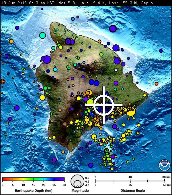
A SEISMIC EVENT HAS OCCURRED NEAR THE SUMMIT OF KĪLAUEA VOLCANO.
THE EVENT IS LIKELY ASSOCIATED WITH A SUMMIT ERUPTION.
ITS PRELIMINARY PARAMETERS ARE:
ORIGIN TIME – 0613 AM HST 18 JUN 2018
COORDINATES – 19.4 NORTH 155.3 WEST
LOCATION – IN THE SUMMIT REGION OF KILAUEA VOLCANO
MAGNITUDE – 5.3VI
NO TSUNAMI IS EXPECTED; HOWEVER, SOME AREAS MAY HAVE EXPERIENCED STRONG SHAKING.
Sunday, June 17, 2018, 10:28 p.m.: HAWAIIAN VOLCANO OBSERVATORY STATUS REPORT
Current Volcano Alert Level: WARNING
Current Aviation Color Code: RED
Kīlauea Volcano Lower East Rift Zone
VIDEO: In this video taken from the Leilani Estates subdivision on June 17, 2018, lava at Fissure 8 pulses above the cinder cone adding fragments of lava (spatter) that build the cone higher. From Fissure 8, lava flows freely over small cascades (rapids) into a well-established channel. Near the vent, lava is traveling about 15 miles per hour. Lava slows to about 1.5 miles per hour) near the ocean entry at Kapoho.
The Lower East Rift Zone (LERZ) eruption in Leilani Estates continues with little change.
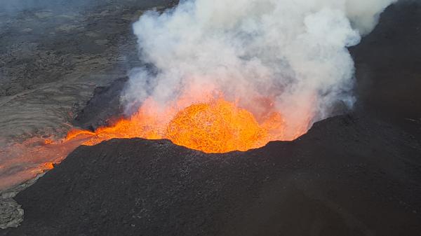
The Fissure 8 lava fountain pulses to heights of 165 feet within a cinder spatter cone. Fissure 8 feeds lava into the well-established channel that flows to the ocean. June 17, 2018. PC: USGS HVO
Fountains ranging between 60 to 165 feet from the Fissure 8 spatter cone continue to feed lava into the well-established channel that flows to the ocean at Kapoho. Occasionally, minor amounts of lava briefly spill over the channel levees. The ocean entry remained fairly broad with laze blown onshore.

Panorama of Lower East Rift Zone camera from Lower East Rift Zone [PGcam]. Last updated June 18, 2018, 6:45 a.m. PC USGS HVO
Fissures 16/18 continue to ooze lava. Incandescence (visible in PGcam to the left of Fissure 8 most nights) and mild spattering were observed from Fissure 6. The flow field is relatively stable with little change to its size and shape for the past few days.
Pele’s Hair and other lightweight volcanic glass fragments from the lava fountain at Fissure 8 continue to fall downwind of the fissure, dusting the ground within a few hundred meters (yards) of the vent. High winds may waft lighter particles to greater distances. Residents are urged to minimize exposure to these volcanic particles, which can cause skin and eye irritation similar to volcanic ash.

The well-channelized flow from Fissure 8 is a nearly 8-mile-long river of lava from Leilani Estates to the ocean in Kapoho on June 17, 2018, at 7:24p.m. PC: Crystal Richard

Green Mountain and the laze plume off the ocean entry flow from Fissure 8 at 6:20 p.m. on June 17, 2018. PC: Crystal Richard
The most recent map of lava flows can be found online.
HVO field crews are on site tracking the fountains, lava flows and spattering from Fissure 8 as conditions allow and are reporting information to Hawai‘i County Civil Defense. Observations are also collected on a daily basis from cracks in the area of Highway 130; no changes in temperature, crack width, or gas emissions have been noted for several days.
Volcanic gas emissions remain very high from Fissure 8 eruptions. Winds are expected to bring vog to the central, south, and western parts of the Island of Hawai‘i. Vog information can be found at https://vog.ivhhn.org/.
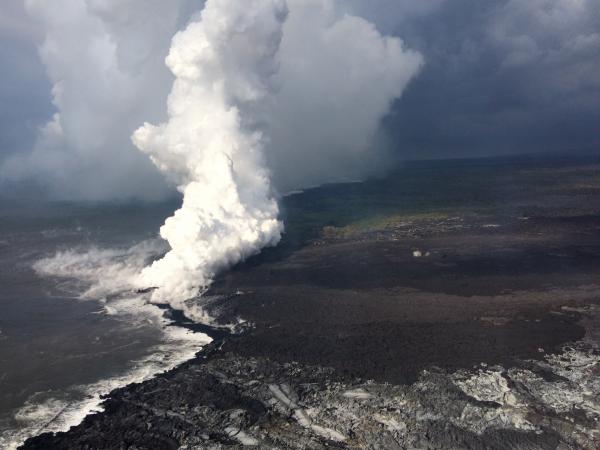
Lava enters the ocean entry in the vicinity of Vacationland on June 17, 2018, producing a vigorous laze plume. Lava flowing into the ocean has built a delta of flows, rock rubble and black sand, which is over 320 acres in size. PC: USGS HVO
The ocean entry is a hazardous area. Venturing too close to an ocean entry on land or the ocean exposes you to flying debris from sudden explosive interaction between lava and water. Also, the lava delta is unstable because it is built on unconsolidated lava fragments and sand. This loose material can easily be eroded away by surf, causing the new land to become unsupported and slide into the sea. Additionally, the interaction of lava with the ocean creates “laze,” a corrosive seawater plume laden with hydrochloric acid and fine volcanic particles that can irritate the skin, eyes and lungs.

Ti lei Hookupu left for Pele overlooking the well-channelized lava flow from Fissure 8 on June 17, 2018, at 6:47 p.m. PC: Crystal Richard
Magma continues to be supplied to the Lower East Rift Zone. Seismicity remains relatively low in the area with numerous small magnitude earthquakes and low amplitude background tremor. Higher amplitude tremor is occasionally being recorded on seismic stations close to the ocean entry.
Additional ground cracking and outbreaks of lava in the area of the active fissures are possible. Residents downslope of the region of fissures should heed all Hawai‘i County Civil Defense messages and warnings.

The sun setting over Fissure 8 from the Bryson Cinder Pits off of Government Beach Road in lower Puna on June 17, 2018, at 7:18 p.m. PC: Crystal Richard
Kīlauea Volcano Summit
Inward slumping of the rim and walls of Halemaʻumaʻu continues in response to ongoing subsidence at the summit. After the explosive collapse at 6:26 a.m. HST on Sunday morning, seismicity at Kīlauea’s summit gradually increased reaching 30 to 35 events per hour by 10 p.m. If the pattern of the last several days holds, another explosive collapse could occur within the next 12 hours or so.
Sulfur dioxide emissions from the volcano’s summit have dropped to levels that are about half those measured prior to the onset of the current episode of eruptive activity. This gas and minor amounts of ash are being transported downwind, with small bursts of ash and gas accompanying intermittent explosive activity.
For forecasts of where ash would fall under forecast wind conditions, consult the Ash3D model output here.
Information on volcanic ash hazards and how to prepare for ash fall maybe found at http://www.ivhhn.org/information#ash (health impacts) OR https://volcanoes.usgs.gov/volcanic_ash/ (other impacts).
Sponsored Content


