

6 PM: Individual FEMA Assistance Available
This news story will be updated throughout the day as new information becomes available and new articles will be added to the website’s “News” section. Previous information about ongoing events can be found in Big Island Now’s “Volcano Blog” section.
KĪLAUEA SUMMIT LIVESTREAM
CLICK HERE FOR JUNE 12 INTERACTIVE MAP
Thursday, June 14, 2018, 6 p.m.: Individual FEMA Assistance Available
Residents of Hawai‘i County who suffered damage or losses from the recent Kilauea volcanic eruption and earthquakes, can now register for disaster assistance with the Federal Emergency Management Agency (FEMA).
- A Disaster Recovery Center (DRC), jointly operated by Hawaii County, the State of Hawaii, and FEMA will open tomorrow, Friday, June 15 at 8 a.m.
- The DRC is located at Kea‘au High School Gymnasium and will be open daily from 8 a.m. to 8 p.m.
- People can register for assistance at the DRC, as well as having many of their questions answered.
- FEMA, the U.S. Small Business Administration, and state and county government agencies will be present at the center.
- For a list of the information you need to bring with you, or if you want to register online, go to www.DisasterAssistance.gov.More information on President Trump’s announcement here: President Trump Approves Individual Assistance for Hawai‘i Island Residents
Thursday, June 14, 2018, 5:30 p.m.: Fissures 16 & 18 Ooze Lava
The eruption of lava continues from the lower East Rift Zone (LERZ) in Leilani Estates with little change over the past few days.
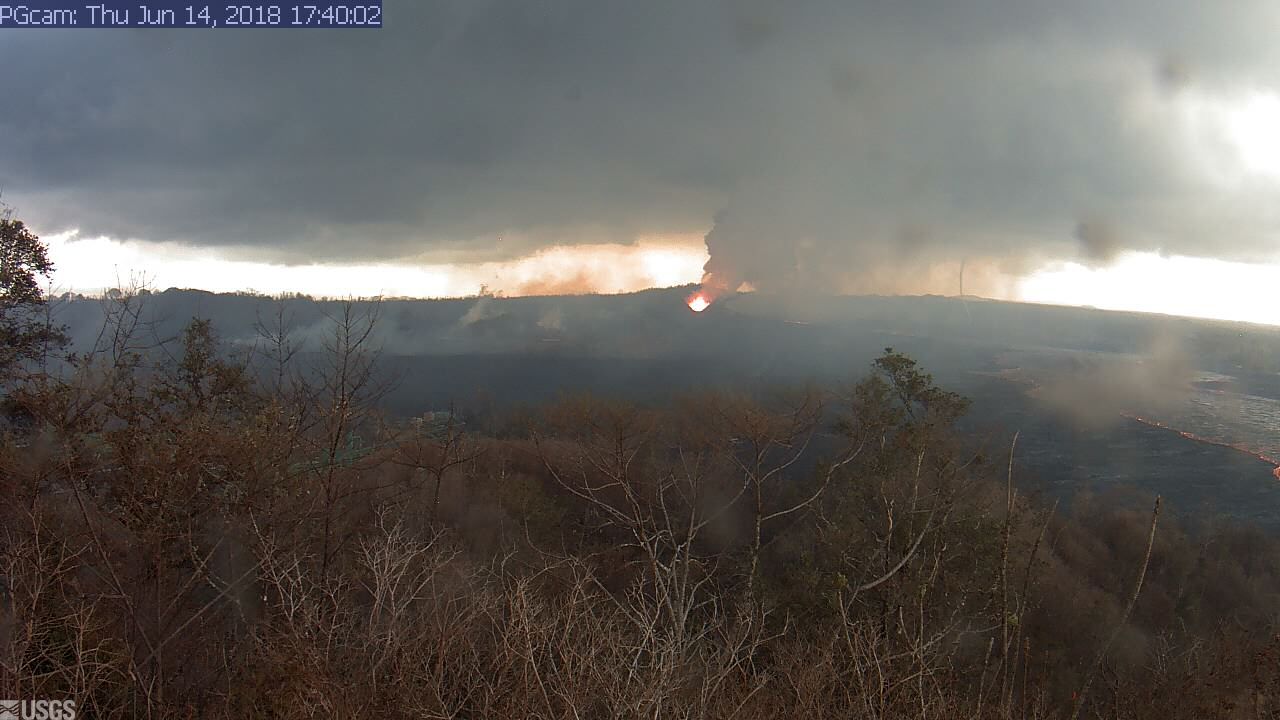
Live Panorama of Lower East Rift Zone Camera from Lower East Rift Zone [PGcam]
Last Updated June 14, 2018, at 5:40 p.m.
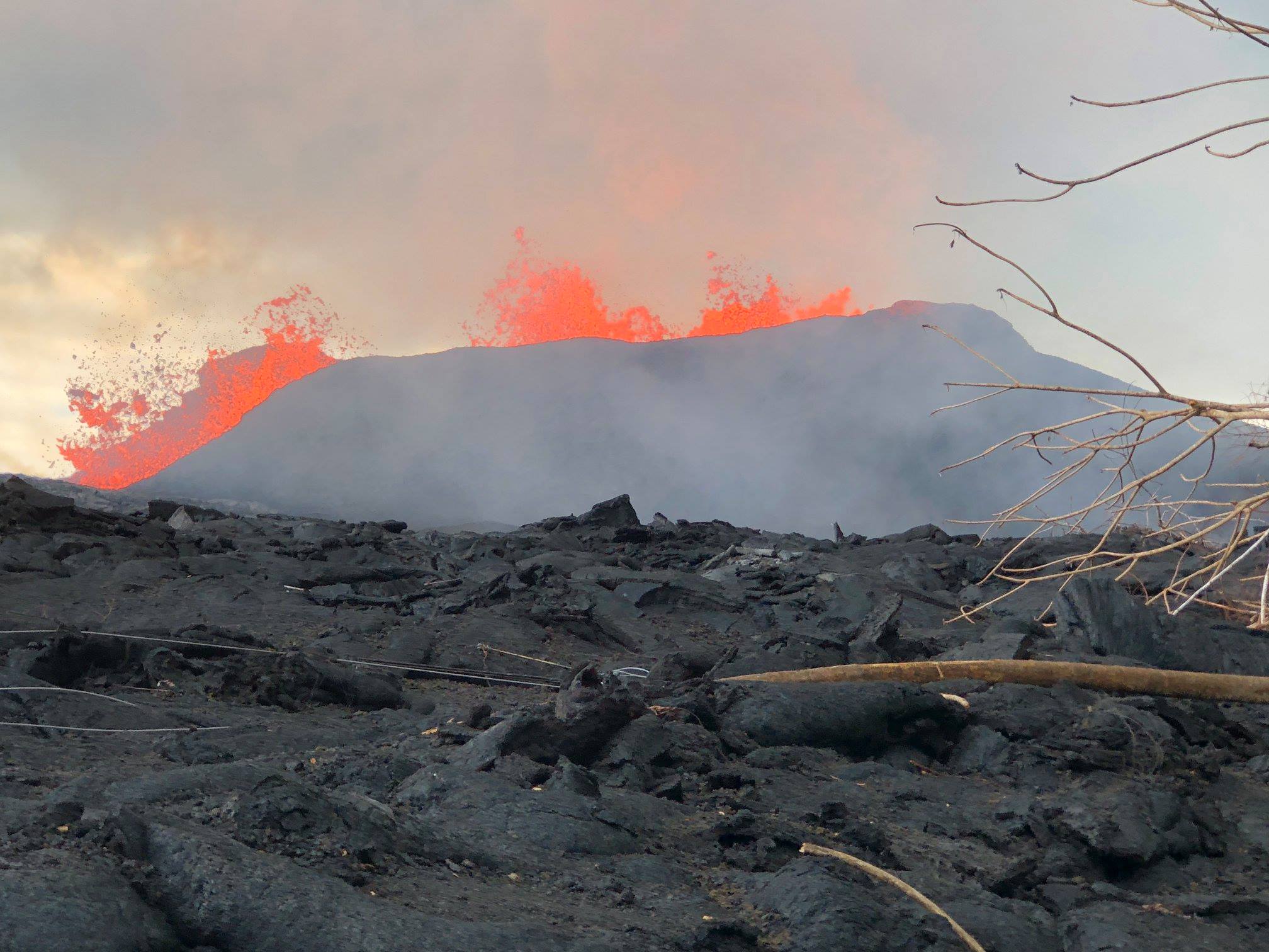
Fissure 8 lava fountains continue to reach heights of 200 feet from within the growing cone of cinder and spatter, which is now about 160 feet at its highest point. Lava from Fissure 8 continues to flow through the well-established channel to the ocean at Kapoho, with rare, small overflows of the channel levees. An early afternoon overflight confirmed that activity at the vent and channel continued with no significant changes. The ocean entry remained fairly broad with one main entry and several minor ones. A laze plume at the ocean entry was blown onshore this morning, and areas of upwelling offshore were present. Fissures 16 and 18 continue to ooze lava.
Pele’s hair and other lightweight volcanic glass fragments from the lava fountain at Fissure 8 continue to fall downwind of the fissure, dusting the ground within a few hundred yards of the vent. High winds may waft lighter particles to greater distances. Residents are urged to minimize exposure to these volcanic particles, which can cause skin and eye irritation similar to volcanic ash.
After this morning’s small explosion at Kīlauea’s summit, seismicity levels immediately dropped but started to increase during the day. Inward slumping of the rim and walls of Halema`uma`u continues in response to ongoing subsidence at the summit.
Sulfur dioxide emissions from the volcano’s summit have dropped to levels that are about half those measured prior to the onset of the current episode of eruptive activity. This gas and minor amounts of ash are being transported downwind, with small bursts of ash and gas accompanying intermittent explosive activity.
Thursday, June 14, 2018, 2:30 p.m.: Eruption Continues, Little Changes
Hawaiian Volcano Observatory reports that the eruption continues with little change in the lower East Rift Zone.
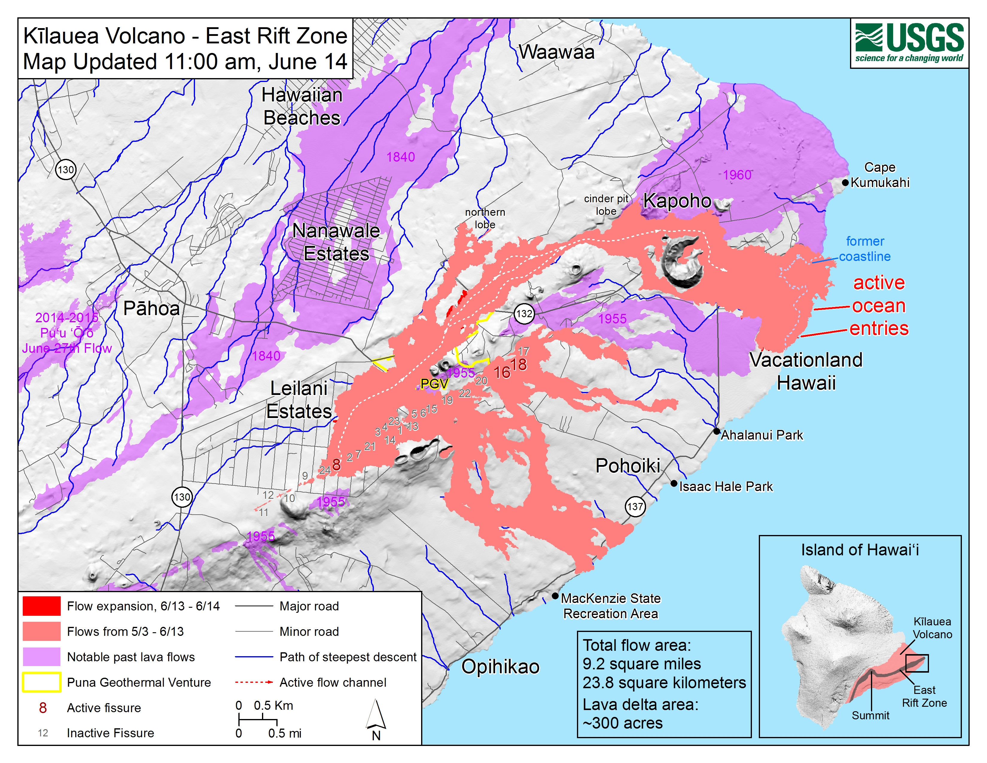
Shaded purple areas indicate lava flows erupted in 1840, 1955, 1960 and 2014-2015. Click to enlarge
Fissure 8 continues to produce a large channelized flow that is entering the ocean at Kapoho Bay and producing a large laze plume. Expect heavier vog to blanket the interior and southern parts of the island, wrapping around to Kona through the weekend.
Due to volcanic and air quality conditions, the following guidance is given:
- Do continue to be on the alert for air quality conditions around you and be cautious.
- The Department of Health recommends limiting outside activities and staying indoors if you have breathing issues.
- You can monitor the latest air quality measurements through the University of Hawai‘i’s Vog Measurement and Prediction Project, linked on our Civil Defense website.
- A community meeting on volcanic ash and vog will be held tonight at 5:30 p.m. at the Ocean View Community Center.
Due to the current volcanic activity, the following policies are in effect:
- Leilani Estates West of Pomaikai Street is open only to residents with official credentials.
- There is no immediate threat, but residents in Leilani, Wa‘a Wa‘a and Papaya Farms Road should heed warnings from Civil Defense officials and be prepared to evacuate with little notice.
The shelter at Pāhoa Community Center is open and pet-friendly. The Kea‘au Armory shelter has reached capacity.
Thursday, June 14, 2018, 10:15 a.m.: Mental health services are available
Mental health services are available on the Big Island. Click on the link to view a Hawai‘i Department of Health flyer.
6 a.m.: Summit explosion carries ash to Ka‘ū, gas emissions remain high
Hawaiian Volcano Observatory reports that the eruption continues in the lower East Rift Zone.
Fissure 8 continues to produce a large channelized flow that is entering the ocean at Kapoho Bay and producing a large laze plume.
Gas emissions from the fissure eruption and at the ocean entry continue to be very high.
Hawaiian Volcano Observatory also reports that an ash explosion occurred at the Kīlauea Summit early this morning, be aware of ash fallout throughout Ka‘ū.
Due to volcanic and air quality conditions, the following guidance is given:
- The Department of Health recommends limiting outside activities and staying indoors if you have breathing issues.
- You can monitor the latest air quality measurements through the University of Hawaii’s Vog Measurement and Prediction Project, through the line on our Civil Defense website.
A community meeting on volcanic ash and vog will be held at 5:30 p.m. at the Ocean View Community Center.
Due to the current volcanic activity, the following policies are in effect:
- Leilani Estates West of Pomaikai Street is open only to residents with official credentials.
- There is no immediate threat, but residents in Leilani, Wa‘a Wa‘a, and Papaya Farms Road should heed warnings from Civil Defense officials and be prepared to evacuate with little notice.
The shelter at Pāhoa Community Center is open and pet-friendly. The Kea‘au Armory shelter has reached capacity.
3:30 a.m.: Summit explosion carries ash to Ka‘ū
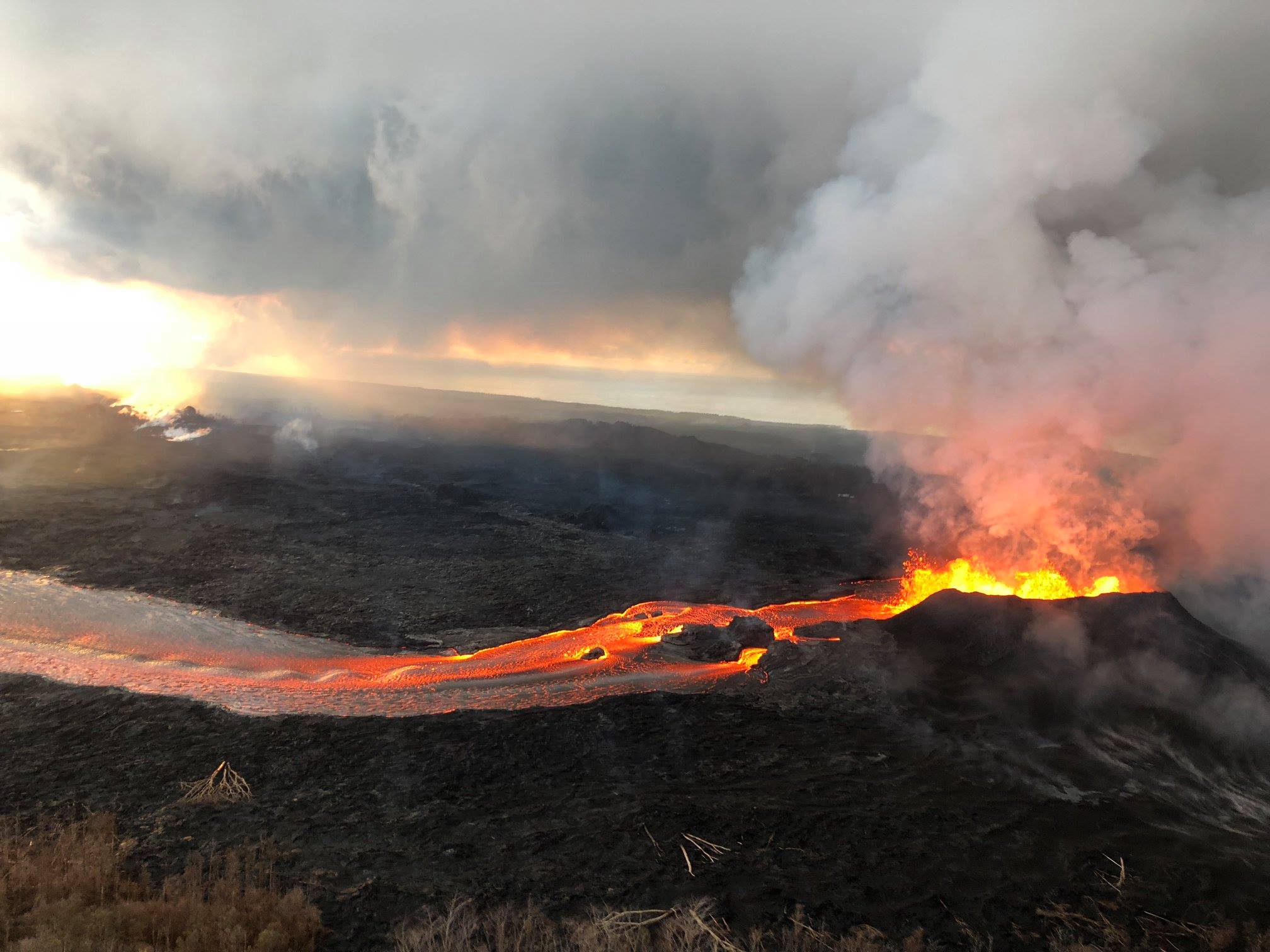
Fissure 8 lava fountain during yesterday morning’s overflight of the lower East Rift Zone. Steam and fume rises from fissures 16 and 18 in distance (upper left). View is toward the east. PC: USGS HVO
Hawaiian Volcano Observatory reports that an explosive eruption at Kīlauea Summit has occurred at 3:20 am.
The resulting ash plume, which rose to 6,000 feet above sea level, may affect the surrounding areas.
The wind may carry the ash plume to the southwest toward Wood Valley, Pahala and Ocean View.
The danger from this eruption is ash fallout. The major response is to protect yourself from fallout.
If you are at home, stay indoors with the windows closed. Turn on your radio and listen for updates from authorities.
If you are in your car, keep the windows closed. Ash fallout may cause poor driving conditions, due to limited visibility and slippery driving conditions.
Drive with extreme caution, or pull over and park.
After the hazard has passed, do check your home, and especially your catchment system for any impact that may affect your water quality.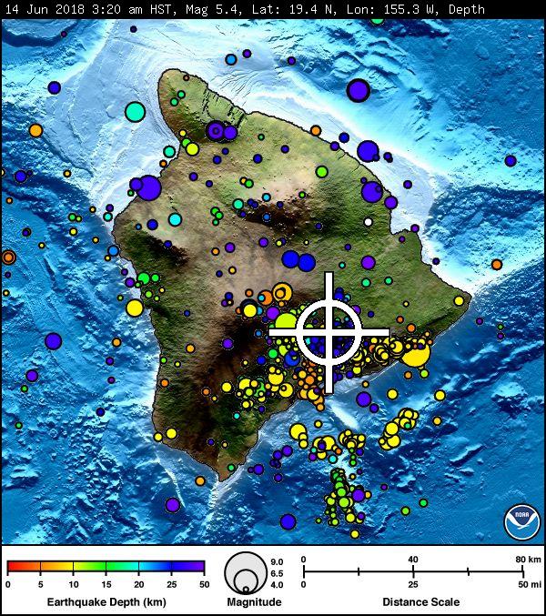
TSUNAMI INFORMATION STATEMENT
A SEISMIC EVENT HAS OCCURRED NEAR THE SUMMIT OF KĪLAUEA VOLCANO.
THE EVENT IS LIKELY ASSOCIATED WITH A SUMMIT ERUPTION.
ITS PRELIMINARY PARAMETERS ARE:
ORIGIN TIME – 0320 AM HST 14 JUN 2018
COORDINATES – 19.4 NORTH 155.3 WEST
LOCATION – IN THE SUMMIT REGION OF KILAUEA VOLCANO
MAGNITUDE – 5.4
NO TSUNAMI IS EXPECTED; HOWEVER, SOME AREAS MAY HAVE EXPERIENCED STRONG SHAKING.
Wednesday, June 13, 10:21 p.m.: HAWAIIAN VOLCANO OBSERVATORY STATUS REPORT
Current Volcano Alert Level: WARNING
Current Aviation Color Code: RED
Kīlauea Volcano Lower East Rift Zone
The eruption of lava continues from the Lower East Rift Zone (LERZ) in Leilani Estates. Lava fountain heights of 100 to 130 feet were observed at Fissure 8 during June 13. PC: USGS HVO
The eruption of lava continues from the Lower East Rift Zone (LERZ) in Leilani Estates with little change over the past few days.
Lava fountains reaching heights of 174 feet were observed at Fissure 8 in the late afternoon. Lava from Fissure 8 continues to flow through the well-established channel to the ocean at Kapoho, with rare, small overflows of the channel levees. A laze plume at the ocean entry was blown onshore this afternoon, and areas of upwelling offshore were present throughout the day.
Pele’s Hair and other lightweight volcanic glass fragments from the lava fountain at Fissure 8 continue to fall downwind of the fissure, dusting the ground within a few hundred yards of the vent. High winds may waft lighter particles to greater distances. Residents are urged to minimize exposure to these volcanic particles, which can cause skin and eye irritation similar to volcanic ash.
HVO field crews are on site tracking the fountains, lava flows, and spattering from Fissure 8 as conditions allow and are reporting information to Hawaii County Civil Defense. Observations are also collected on a daily basis from cracks in the area of Highway 130; no changes in temperature, crack width, or gas emissions have been noted for several days.
Volcanic gas emissions remain very high from Fissure 8 eruptions. Gas emissions have increased over the past two weeks. Wind conditions are changing and may bring VOG to the central, south, and western parts of the Island of Hawaii. VOG information can be found online.
Fissures 16 and 18 continue to ooze lava.

June 13 view of the ocean entry and the resulting laze plume where lava is entering the sea. As of June 12, lava entering the ocean had added about 250 acres of new land to the Island of Hawai‘i. PC: USGS HVO
The ocean entry is a hazardous area. Venturing too close to an ocean entry on land or the ocean exposes you to flying debris from sudden explosive interaction between lava and water. Also, the lava delta is unstable because it is built on unconsolidated lava fragments and sand. This loose material can easily be eroded away by surf, causing the new land to become unsupported and slide into the sea. Additionally, the interaction of lava with the ocean creates “laze,” a corrosive seawater plume laden with hydrochloric acid and fine volcanic particles that can irritate the skin, eyes and lungs.
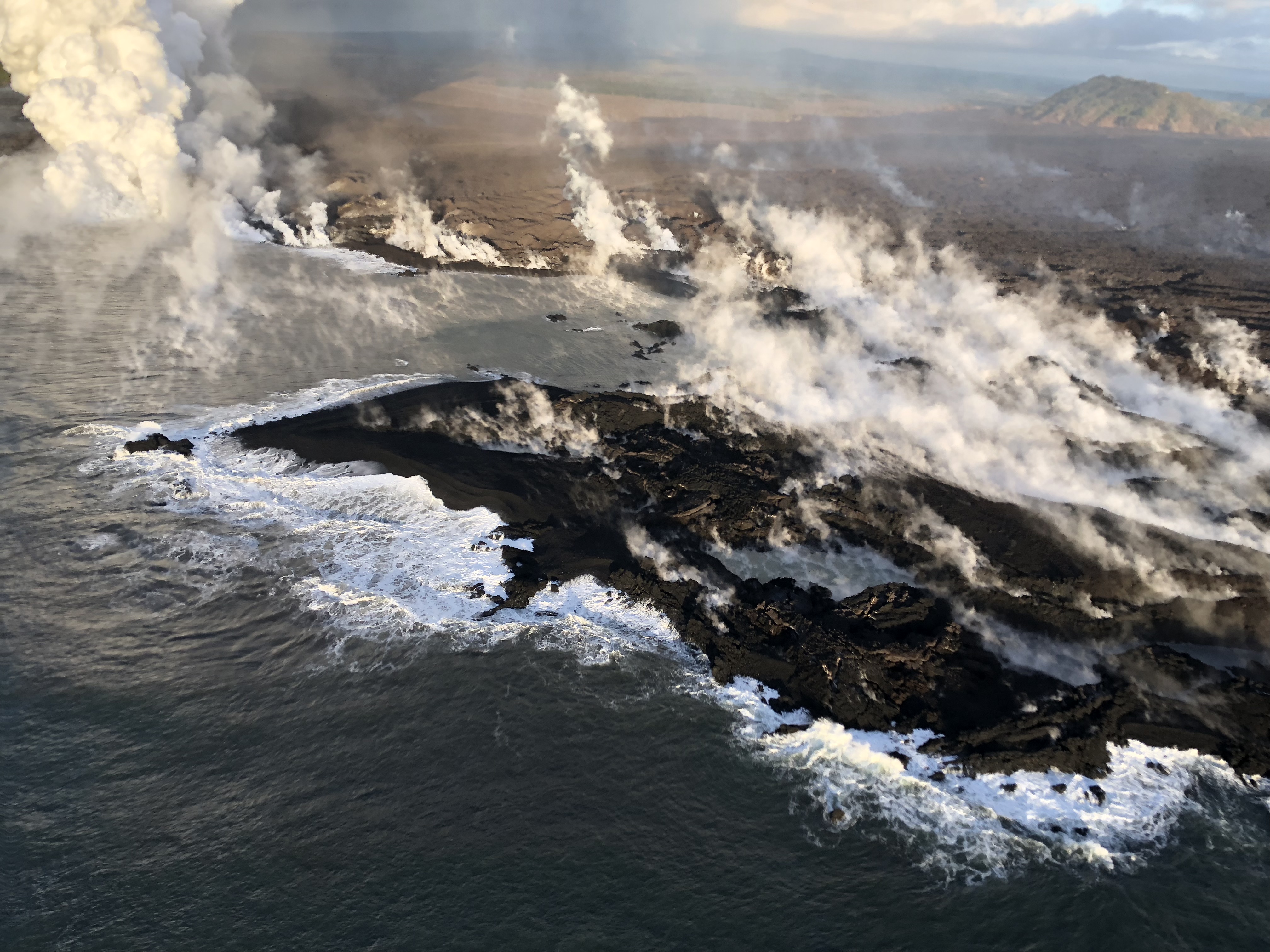
Closer view of new land in the Kapoho area, June 13. The new coastline, following the ragged lava-ocean interface, is approximately 1.3 miles in length. The white steam/laze plume marks the location of the most active lava entry site during the morning overflight. PC: USGS HVO
Magma continues to be supplied to the Lower East Rift Zone. Seismicity remains relatively low in the area with numerous small magnitude earthquakes and low amplitude background tremor. Higher amplitude tremor is occasionally being recorded on seismic stations close to the ocean entry.
Additional ground cracking and outbreaks of lava in the area of the active fissures are possible. Residents downslope of the region of fissures should heed all Hawai‘i County Civil Defense messages and warnings.
VIDEO: Aerial views of the ocean entry on Kīlauea Volcano’s lower East Rift Zone on June 12, 2018, around 6:30 a.m.
Kīlauea Volcano Summit
Following this morning’s small explosion at Kīlauea’s summit, earthquake activity returned to low levels for much of the day, but began a steady increase by this late afternoon. Inward slumping of the rim and walls of Halema‘uma‘u continues in response to ongoing subsidence at the summit.
Sulfur dioxide emissions from the volcano’s summit have dropped to levels that are about half those measured prior to the onset of the current episode of eruptive activity. This gas and minor amounts of ash are being transported downwind, with small bursts of ash and gas accompanying intermittent explosive activity.
For forecasts of where ash would fall under forecast wind conditions, consult the Ash3D model output here.
Information on volcanic ash hazards and how to prepare for ash fall maybe found at http://www.ivhhn.org/information#ash (health impacts) OR https://volcanoes.usgs.gov/volcanic_ash/ (other impacts).
Sponsored Content


