

10:30 PM: Residents Urged to Minimize Exposure to Volcanic Particles
This news story will be updated throughout the day as new information becomes available and new articles will be added to the website’s “News” section. Previous information about ongoing events can be found in Big Island Now’s “Volcano Blog” section.
KĪLAUEA SUMMIT LIVESTREAM
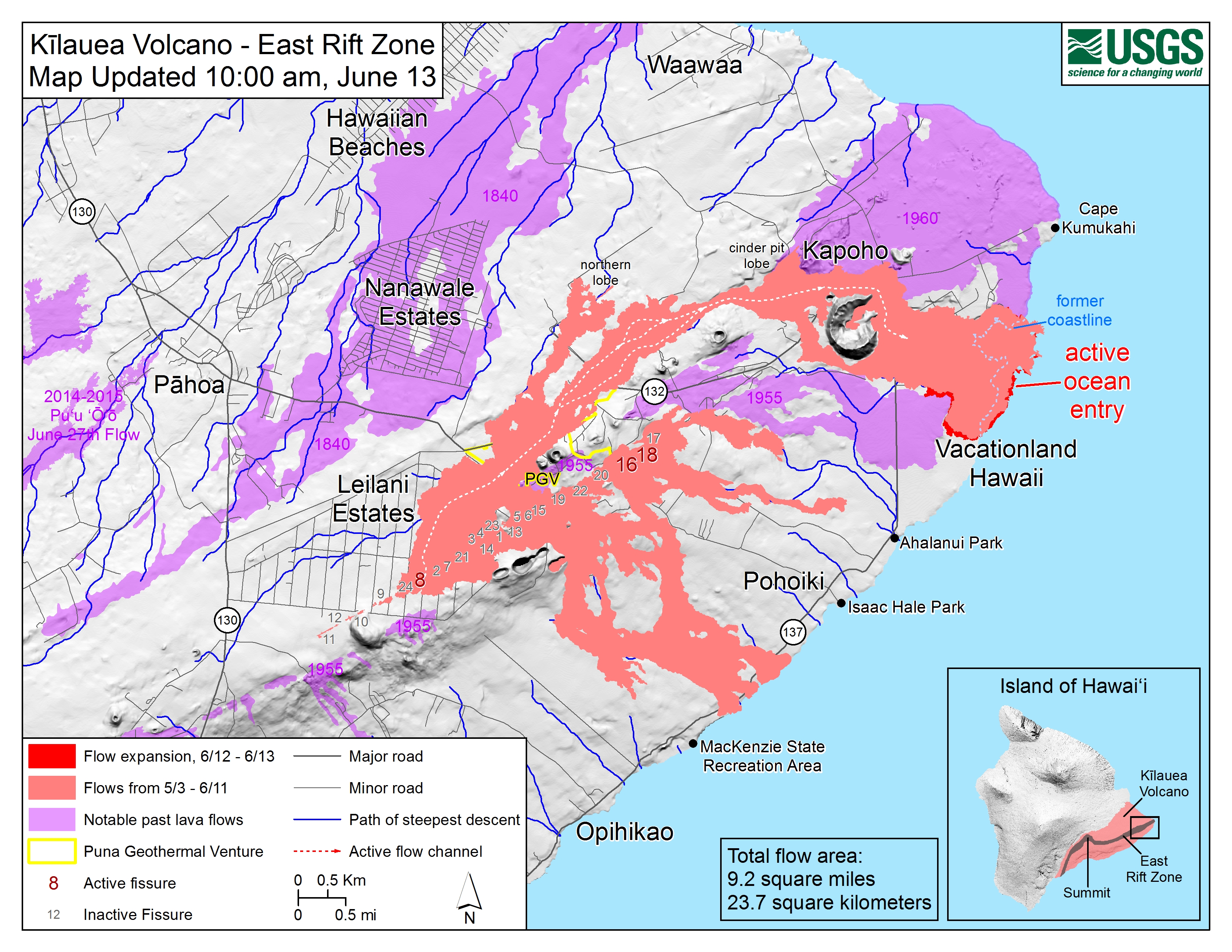
CLICK HERE FOR JUNE 12 INTERACTIVE MAP
Wednesday, June 13, 2018, 10:30 p.m.: Residents Urged to Minimize Exposure to Volcanic Particles
The eruption of lava continues from the lower East Rift Zone (LERZ) in Leilani Estates with little change over the past few days.
Lava fountains reaching heights of 174 feet were observed at Fissure 8 in the late afternoon. Lava from Fissure 8 continues to flow through the well-established channel to the ocean at Kapoho, with rare, small overflows of the channel levees. A laze plume at the ocean entry was blown onshore this afternoon, and areas of upwelling offshore were present throughout the day. Fissures 16 and 18 continue to ooze lava.
Pele’s hair and other lightweight volcanic glass fragments from the lava fountain at Fissure 8 continue to fall downwind of the fissure, dusting the ground within a few hundred yards of the vent. High winds may waft lighter particles to greater distances. Residents are urged to minimize exposure to these volcanic particles, which can cause skin and eye irritation similar to volcanic ash.
Wednesday, June 13, 2018, 4:30 p.m.: Lava Spreading Northeast
The eruption of lava continues from the lower East Rift Zone (LERZ) in Leilani Estates.
Lava fountain heights of 100-130 feet were observed at Fissure 8 during the day. Lava spreading northeast from the fissure flowed through the well-established channel to the ocean at Kapoho, with rare small overflows of the channel levees. A laze plume at the ocean entry was blown onshore this afternoon, and areas of upwelling offshore were present throughout the day. The limited activity at fissures 16 and 18 of the past several days (spattering and small flows) continues this afternoon.
Pele’s hair and other lightweight volcanic glass fragments from the lava fountain at fissure 8 continue to fall downwind of the fissure, with accumulation on the ground mostly within a few hundred yards. High winds may waft lighter particles to greater distances. Residents are urged to minimize exposure to these volcanic particles, which can cause skin and eye irritation similar to volcanic ash.
Click to enlarge
Following this mornings small explosion at Kīlauea’s summit, earthquake activity returned to low levels for much of the day, but began a steady increase by this late afternoon. Inward slumping of the rim and walls of Halema`uma`u continues in response to ongoing subsidence at the summit.
Sulfur dioxide emissions from the volcano’s summit have dropped to levels that are about half those measured prior to the onset of the current episode of eruptive activity. This gas and minor amounts of ash are being transported downwind, with small bursts of ash and gas accompanying intermittent explosive activity.
Wednesday, June 13, 2018, 12:30 p.m.:
The National Weather Service reports slow winds will bring vog inland and to the south, wrapping around to the Kona area. The heavy vog conditions are expected to stay this way until the early part of next week.
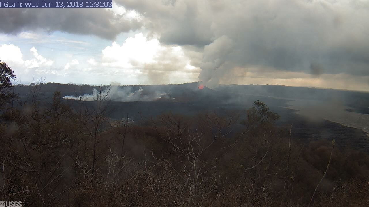
Live Panorama of Lower East Rift Zone Camera from Lower East Rift Zone [PGcam]
Last Updated June 13, 2018 at 12:31 p.m.
Due to volcanic and air quality conditions, the following guidance is given:
- The Department of Health recommends limiting outside activities and staying indoors if you have breathing issues.
- You can monitor the latest air quality measurements through the University of Hawai‘i’s Vog Measurement and Prediction Project, linked on the Civil Defense website.
- A community meeting on volcanic ash and vog will be held at 5:30 p.m. this Thursday at the Ocean View Community Center.
The shelter at Pāhoa Community Center is open and pet-friendly. The Kea‘au Armory shelter has reached capacity.
Wednesday, June 13, 2018, 6 a.m.: Explosive eruption at Kīlauea Summit
Hawaiian Volcano Observatory reports that the eruption continues in the lower East Rift Zone.
Fissure 8 continues to produce a large channelized flow that is entering the ocean at Kapoho Bay and producing a large laze plume.
Gas emissions from the fissure eruption and at the ocean entry continue to be very high.
Hawaiian Volcano Observatory also reports that a steam explosion occurred at the Kīlauea Summit early this morning, be aware of ash fallout throughout Ka‘ū.
Due to volcanic and air quality conditions, the following guidance is given:
- The Department of Health recommends limiting outside activities and staying indoors if you have breathing issues.
- You can monitor the latest air quality measurements through the University of Hawaii’s Vog Measurement and Prediction Project, through the line on our Civil Defense website.
A community meeting on volcanic ash and vog will be held at 5:30 p.m. on Thursday, June 14, at the Ocean View Community Center.
Due to the current volcanic activity, the following policies are in effect:
- Leilani Estates West of Pomaikai Street is open only to residents with official credentials.
- Government Beach Road, between Kahakai Boulevard and Cinder Road is open to Waa Waa and Papaya Farms Road only to residents with official credentials.
- There is no immediate threat, but residents in these areas should heed warnings from Civil Defense officials and be prepared to evacuate with little notice.
The shelter at Pāhoa Community Center is open and pet-friendly. The Kea‘au Armory shelter has reached capacity.
Fissure 8 image taken June 13, 2018, around 6 a.m. PC:USGS
PHOTO: How much lava is flowing through the fissure 8 vent? The USGS has an approximate (and probably low) effusion rate estimate of around 100 cubic meters per second. That’s equivalent to about 26,000 U.S. gallons flowing by per second
or 12 commercial dump trucks driving by per second.
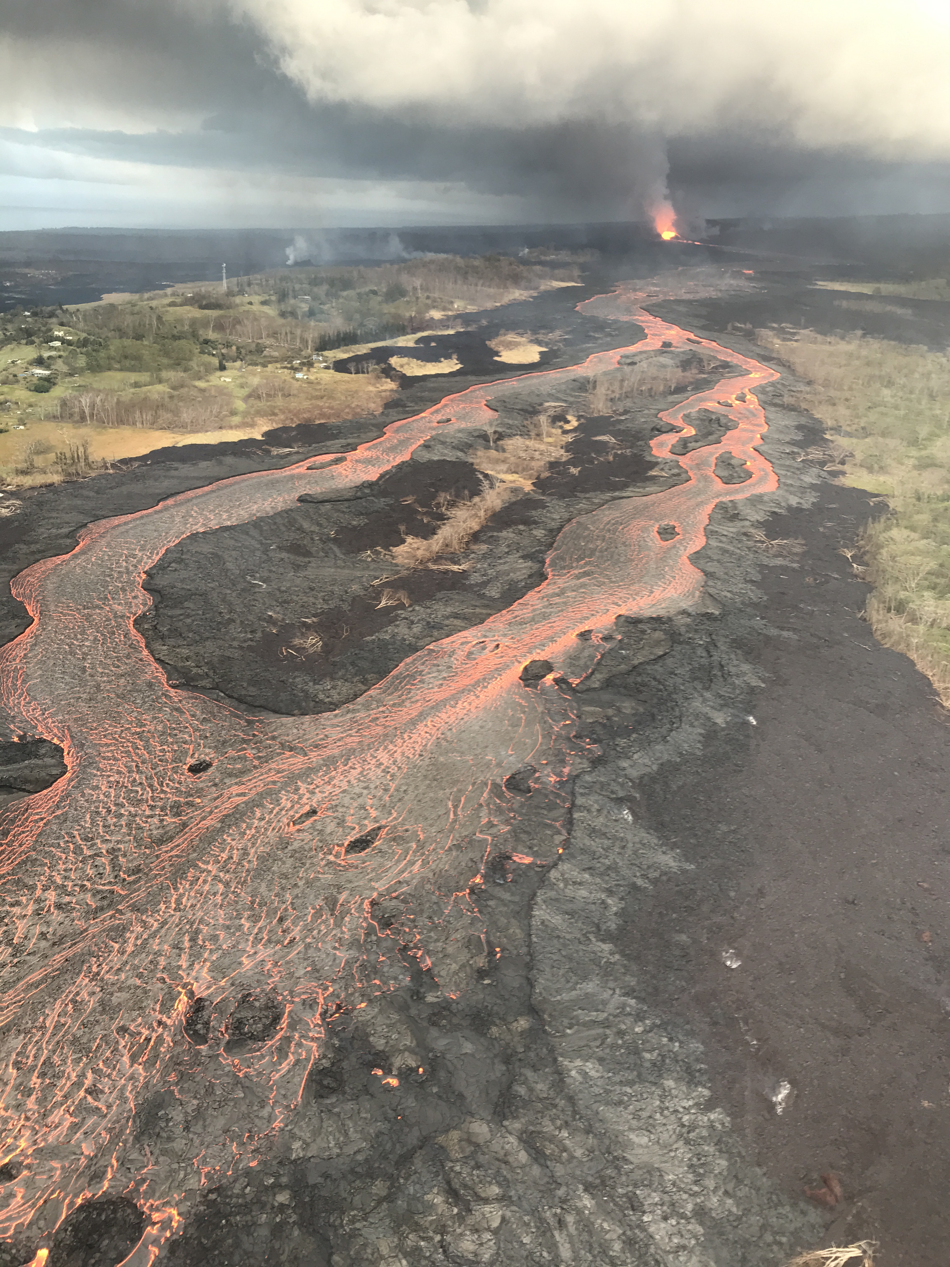
The image above is from this morning’s helicopter overflight of Kīlauea Volcano’s lower East Rift Zone. Fissure 8 lava fountains continue to reach heights of 130 feet from within the growing cone of cinder and spatter, which is now about 140 feet at its highest point. Fountaining at Fissure 8 feeds the fast-moving channelized flow that is entering the ocean at Kapoho. The prominent ocean entry is creating a vigorous steam/laze plume. The new coastline created by lava (following all the ins-and-outs of the lava/ocean interface) is about 1.8 miles long.
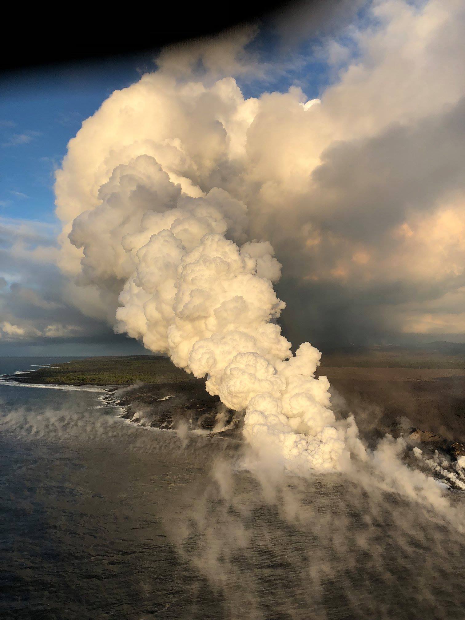
Ocean entry, June 13, 2018, around 6 a.m. PC: USGS
4 a.m.: Explosive eruption at Kīlauea Summit
Hawaiian Volcano Observatory reported that an explosive eruption at Kīlauea Summit has occurred at 3:40 a.m. The resulting ash plume may affect the surrounding areas. The wind may carry the ash plume to the southwest toward Wood Valley, Pahala and Ocean View.
The danger from this eruption is ash fallout. The major response is to protect yourself from fallout.
If you are at home, stay indoors with the windows closed. Turn on your radio and listen for updates from authorities.
Fissure 8 (fountain visible in distance) feeds lava into an active braided channel that flows about 8 miles (north, then east) to the ocean entry in Kapoho Bay. USGS image taken June 12, 2018, around 6:50 a.m.
If you are in your car, keep the windows closed. Ash fallout may cause poor driving conditions, due to limited visibility and slippery driving conditions. Drive with extreme caution, or pull over and park.
After the hazard has passed, do check your home, and especially your catchment system for any impact that may affect your water quality.
3:45 a.m.: TSUNAMI INFORMATION STATEMENT
A SEISMIC EVENT HAS OCCURRED NEAR THE SUMMIT OF KĪLAUEA VOLCANO.
THE EVENT IS LIKELY ASSOCIATED WITH A SUMMIT ERUPTION.
ITS PRELIMINARY PARAMETERS ARE
ORIGIN TIME 3:40 AM HST 13 JUN 2018
COORDINATES – 19.4 NORTH 155.3 WEST
LOCATION – IN THE SUMMIT REGION OF KILAUEA VOLCANO
MAGNITUDE – 5.4
NO TSUNAMI IS EXPECTED; HOWEVER, SOME AREAS MAY HAVE EXPERIENCED STRONG SHAKING.
Tuesday, June 12, 2018, 11:04: HAWAIIAN VOLCANO OBSERVATORY STATUS REPORT

Fissure 8 fountains reached heights up to 160 feet overnight. Lava fragments falling from the fountains are building a cinder-and-spatter cone around the vent, with the highest part of the cone (about 125 feet high) on the downwind side. USGS image taken June 12, 2018, around 6:10 a.m. PC: USGS HVO
KĪLAUEA VOLCANO (VNUM #332010)
Current Volcano Alert Level: WARNING
Current Aviation Color Code: RED
Kīlauea Volcano Lower East Rift Zone
Eruption of lava continues from the lower East Rift Zone (LERZ) fissure system in the area of Leilani Estates.
Fissure 8 lava fountains continue to heights of 130-140 feet from within the growing cone of cinder and spatter, which is now about 140 feet at its highest point. Fountaining at Fissure 8 continues to feed the fast moving channelized flow that is entering the ocean at Kapoho. Two prominent entries are creating vigorous steam plumes. Offshore of the entries, areas of upwelling have become more dispersed than when initially sighted. The sporadic spattering from Fissures 16/18 of the last several days has diminished.
Pele’s hair and other lightweight volcanic glass from fountaining of Fissure 8 are falling downwind of the fissure and accumulating on the ground within Leilani Estates. High winds may waft lighter particles to greater distances. Residents are urged to minimize exposure to these volcanic particles, which can cause skin and eye irritation similar to volcanic ash.
HVO field crews are on site tracking the fountains, lava flows, and spattering from Fissure 8 as conditions allow and are reporting information to Hawai‘i County Civil Defense. Observations are also collected on a daily basis from cracks in the area of Highway 130; no changes in temperature, crack width, or gas emissions have been noted for several days.
Volcanic gas emissions remain very high from Fissure 8 eruptions. Gas emissions have increased over the past two weeks. Trade wind conditions are expected to bring VOG to the south and west sides of the Island of Hawaii. VOG information can be found online.
The ocean entry is a hazardous area. Venturing too close to an ocean entry on land or the ocean exposes you to flying debris from sudden explosive interaction between lava and water. Also, the lava delta is unstable because it is built on unconsolidated lava fragments and sand. This loose material can easily be eroded away by surf, causing the new land to become unsupported and slide into the sea. Additionally, the interaction of lava with the ocean creates “laze”, a corrosive seawater plume laden with hydrochloric acid and fine volcanic particles that can irritate the skin, eyes, and lungs.
Magma continues to be supplied to the lower East Rift Zone. Seismicity remains relatively low in the area with numerous small magnitude earthquakes and low amplitude background tremor. Higher amplitude tremor is occasionally being recorded on seismic stations close to the ocean entry.
Additional ground cracking and outbreaks of lava in the area of the active fissures are possible. Residents downslope of the region of fissures should heed all Hawaii County Civil Defense messages and warnings.
Kīlauea Volcano Summit
Seismicity continues to increase after this morning’s explosive eruption. Inward slumping of the rim and walls of Halema‘uma‘u continues in response to ongoing subsidence at the summit.
Sulfur dioxide emissions from the volcano’s summit have dropped to levels that are about half those measured prior to the onset of the current episode of eruptive activity. This gas and minor amounts of ash are being transported downwind, with small bursts of ash and gas accompanying intermittent explosive activity.
For forecasts of where ash would fall under forecast wind conditions, please consult the Ash3D model output here.
Information on volcanic ash hazards and how to prepare for ash fall maybe found at http://www.ivhhn.org/information#ash (health impacts) OR https://volcanoes.usgs.gov/volcanic_ash/ (other impacts).
Sponsored Content


