

6 PM: Large Laze Plume
Previous information about ongoing events can be found in Big Island Now’s “Volcano Blog” section.
KĪLAUEA SUMMIT LIVESTREAM
CLICK HERE FOR JUNE 10 INTERACTIVE MAP
Monday, June 11, 2018, 6 p.m., Large laze plume
Hawaiian Volcano Observatory reports that the eruption continues in the lower East Rift Zone. Fissure 8 in Leilani Estates continues to produce a large channelized flow that is entering the ocean at Kapoho and producing a large laze plume. Gas emissions from the fissure eruption and at the ocean entry continue to be very high. The National Weather Service reports trade winds are pushing vog southwest around the southern part of the island to the Kona area.

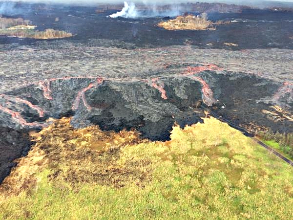
Live Panorama of Lower East Rift Zone Camera from Lower East Rift Zone [PGcam]
Last Updated June 11, 2018 at 6:20 p.m.
Due to volcanic and air quality conditions, the following guidance is given:
- The Department of Health recommends limiting outside activities and staying indoors if you have breathing issues.
- You can monitor latest air quality measurements through the University of Hawaii’s Vog Measurement and Prediction Project at http://mkwc.ifa.hawaii.edu/vmap/
- A community meeting on volcanic ash and vog will be held at 5:30 p.m. this Thursday at the Ocean View Community Center.

Click to enlarge
ADVERTISEMENT
ad_queue.push(“14||28||49”);
ad_queue.push(“14||28||50”);
ad_queue.push(“14||28||75”);
var mobile_text_ad_hide = function(){ if(jQuery(window).width() > 600) { jQuery(“.mobile_text_ads”).hide(); } }; jquery_queue.push(“mobile_text_ad_hide();”);
Due to the current volcanic activity, the following policies are in effect:
- Leilani Estates West of Pomaikai Street is open only to residents with official credentials.
- Government Beach Road, between Kahakai Boulevard and Cinder Road is open to Wa‘a Wa‘a and Papaya Farms Road only to residents with official credentials.
- There is no immediate threat, but residents in these areas, do need to heed warnings from Civil Defense officials and be prepared to evacuate with little notice.
The shelter at Pāhoa Community Center is open and pet-friendly. The Kea‘au Armory shelter has reached capacity.
4 p.m., County and FEMA Update
(function(d, s, id) { var js, fjs = d.getElementsByTagName(s)[0]; if (d.getElementById(id)) return; js = d.createElement(s); js.id = id; js.src = ‘https://connect.facebook.net/en_US/sdk.js#xfbml=1&version=v3.0’; fjs.parentNode.insertBefore(js, fjs);}(document, ‘script’, ‘facebook-jssdk’));
HAWAI‘I ISLAND: Civil Defense press briefing for Monday, June 11, 2018, at 3 p.m.For more information on the eruptions and lava flows, see http://www.bigislandnow.com#PunaLavaFlow #BigIslandNowNEWS #BigIslandNowVOLCANO #PrayForPuna #BigIslandNow
Posted by BigIslandNow.com on Monday, June 11, 2018
3 p.m., HVO video update: Summit crater continues to collapse
(function(d, s, id) { var js, fjs = d.getElementsByTagName(s)[0]; if (d.getElementById(id)) return; js = d.createElement(s); js.id = id; js.src = ‘https://connect.facebook.net/en_US/sdk.js#xfbml=1&version=v3.0’; fjs.parentNode.insertBefore(js, fjs);}(document, ‘script’, ‘facebook-jssdk’));
HAWAI‘I ISLAND: Civil Defense press briefing for Monday, June 11, 2018, at 3 p.m.For more information on the eruptions and lava flows, see http://www.bigislandnow.com#PunaLavaFlow #BigIslandNowNEWS #BigIslandNowVOLCANO #PrayForPuna #BigIslandNow
Posted by BigIslandNow.com on Monday, June 11, 2018
- Eruption of lava continues from the lower East Rift Zone (LERZ) fissure system in the area of Leilani Estates.
- Three closely spaced lava fountains at Fissure 8 are erupting with fluctuating heights from below the 115 ft high spatter cone around it up to 180 feet.
- Lava continues to be fed into the channelized flow trending north and then east to a single ocean entry at Kapoho. Weak lava activity at Fissures 16/18 was observed last night.
- This morning’s overflight confirms that fountaining continues at Fissure 8 and that its channel is nearly full with no spillovers. Minor steam explosions were observed at the ocean entry.
- Pele’s hair and other lightweight volcanic glass from fountaining of Fissure 8 are falling downwind of the fissure and accumulating on the ground within Leilani Estates. High winds may waft lighter particles to greater distances. Residents are urged to minimize exposure to these volcanic particles, which can cause skin and eye irritation similar to volcanic ash.
Kīlauea Volcano Summit
Seismicity levels have been increasing since the most recent small explosion at 4:43 a.m. this morning. There have been no ash emissions since that early morning event. Inward slumping of the rim and walls of Halema`uma`u continues in response to ongoing subsidence at the summit.
Sulfur dioxide emissions from the volcano’s summit have dropped to levels that are about half those measured prior to the onset of the current episode of eruptive activity. This gas and minor amounts of ash are being transported downwind, with small bursts of ash and gas accompanying intermittent explosive activity.
Noon: Vog headed Kona-side
Hawaiian Volcano Observatory reports that the eruption continues in the Lower East Rift Zone.
Fissure 8 in Leilani Estates continues to produce a large channelized flow that is entering the ocean at Kapoho and producing a large laze plume.
Gas emissions from the fissure eruption and at the ocean entry continue to be very high. The National Weather Service reports trade winds are pushing vog southwest around the southern part of the island to the Kona area.
Due to volcanic and air quality conditions, the following guidance is given:
- The Department of Health recommends limiting outside activities and staying indoors if you have breathing issues. If possible, close the windows and use your air conditioner.
- Avoid the laze plume at the ocean entry.
You can monitor latest air quality measurements through the University of Hawai‘i’s Vog Measurement and Prediction Project at http://mkwc.ifa.hawaii.edu/vmap/.
Due to the current volcanic activity, the following policies are in effect:
- Leilani Estates West of Pomaikai Street is open only to residents with official credentials; there is no curfew.
- Government Beach Road, between Kahakai Boulevard and Cinder Road is open to Wa‘a Wa‘a and Papaya Farms Road only to residents with official credentials; there is no curfew.
There is no immediate threat, but residents in these areas must heed warnings from Civil Defense officials and be prepared to evacuate with little notice.
9:01 a.m.: HAWAIIAN VOLCANO OBSERVATORY STATUS REPORT
Current Volcano Alert Level: WARNING
Current Aviation Color Code: RED
Kīlauea Volcano Lower East Rift Zone
Eruption of lava continues from the Lower East Rift Zone (LERZ) fissure system in the area of Leilani Estates.
The three closely spaced lava fountains at Fissure 8 are erupting with a slightly lower maximum heights of 115 to 130 feet. Lava continues to be fed into the channelized flow trending north and then east to a single ocean entry at Kapoho.
This morning’s overflight confirms that fountaining continues at Fissure 8 and that its channel is nearly full with no spillovers. Minor steam explosions were observed at the ocean entry.
Pele’s Hair and other lightweight volcanic glass from fountaining of Fissure 8 are falling downwind of the fissure and accumulating on the ground within Leilani Estates. High winds may waft lighter particles to greater distances. Residents are urged to minimize exposure to these volcanic particles, which can cause skin and eye irritation similar to volcanic ash.
HVO field crews are on site tracking the fountains, lava flows and spattering from Fissure 8 as conditions allow and are reporting information to Hawaii County Civil Defense. Observations are also collected on a daily basis from cracks in the area of Highway 130; no changes in temperature, crack width, or gas emissions have been noted for several days.
Volcanic gas emissions remain very high from Fissure 8 eruptions. Gas emissions were recently measured to be nearly twice the value of the past two weeks. Trade wind conditions are expected to bring vog to the south and west sides of the Island of Hawai‘i.
Weak lava activity at Fissures 16/18 was observed last night.
The ocean entry is a hazardous area. Venturing too close to an ocean entry on land or the ocean exposes you to flying debris from sudden explosive interaction between lava and water. Also, the lava delta is unstable because it is built on unconsolidated lava fragments and sand. This loose material can easily be eroded away by surf, causing the new land to become unsupported and slide into the sea. Additionally, the interaction of lava with the ocean creates “laze,” a corrosive seawater plume laden with hydrochloric acid and fine volcanic particles that can irritate the skin, eyes, and lungs.
Magma continues to be supplied to the lower East Rift Zone. Seismicity remains relatively low in the area with numerous small magnitude earthquakes and low amplitude background tremor. Higher amplitude tremor is occasionally being recorded on seismic stations close to the ocean entry.
Additional ground cracking and outbreaks of lava in the area of the active fissures are possible. Residents downslope of the region of fissures should heed all Hawaii County Civil Defense messages and warnings.
Kīlauea Volcano Summit
Overnight, there were two explosions at the volcano’s summit. The first, smaller event occurred at 12:46 a.m. Following this event, seismicity did not significantly drop off and a second explosion occurred at 4:43 a.m.. This event was larger than the first and was more typical of the size of events that have been occurring at the summit over the past week. Inward slumping of the rim and walls of Halema‘uma‘u continues in response to ongoing subsidence at the summit.
Sulfur dioxide emissions from the volcano’s summit have dropped to levels that are about half those measured prior to the onset of the current episode of eruptive activity. This gas and minor amounts of ash are being transported downwind, with small bursts of ash and gas accompanying intermittent explosive activity.
For forecasts of where ash would fall under forecast wind conditions, please consult the Ash3D model output here.
Information on volcanic ash hazards and how to prepare for ash fall maybe found at http://www.ivhhn.org/information#ash (health impacts) OR https://volcanoes.usgs.gov/volcanic_ash/ (other impacts).
6 a.m: Volcanic gas emissions remain very high
Hawaiian Volcano Observatory reports that the eruption continues in the lower East Rift Zone. Fissure 8 continues to produce a large channelized flow that is entering the ocean at Kapoho Bay and producing a large laze plume.
Hawaiian Volcano Observatory also reports that a steam explosion occurred at the Kīlauea Summit early this morning, so be aware of ash fallout if your commute takes you through Ka‘ū.

Panorama of Lower East Rift Zone from camera in Lower East Rift Zone [PGcam], June 11, 2018, 6:59 a.m. PC: USGS
Due to the lava entering the ocean, the following policies are in effect:
- Avoid the laze plume.
- Be aware that the laze plume travels with the wind and can change direction without warning.
Due to the current volcanic activity, the following policies are in effect:
- Leilani Estates West of Pomaikai Street is open only to residents with official credentials; there is no curfew.
- Government Beach Road, between Kahakai Boulevard and Cinder Road is open to Wa‘a Wa‘a and Papaya Farms Road only to residents with official credentials; there is no curfew.
- Residents in these areas should heed warnings from Civil Defense officials and be prepared to evacuate with little notice.
The shelter at Pāhoa Community Center is open and pet-friendly. The Kea‘au Armory shelter has reached capacity.
Hawaiian Volcano Observatory reports volcanic gas emissions remain very high from fissure eruptions.
Due to the elevated gas levels, the following is provided for your information:
- If you feel the effects of gas exposure shelter-in-place or leave the immediate area.
- You can monitor sulfur dioxide and hydrogen sulfide on Hawaii Island by visiting the Civil Defense website.
4:47 a.m.: No tsunami from 5.4M quake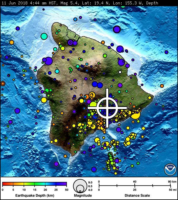
AN EARTHQUAKE HAS OCCURRED WITH THESE PRELIMINARY PARAMETERS
ORIGIN TIME – 0444 AM HST 11 JUN 2018
COORDINATES – 19.4 NORTH 155.3 WEST
LOCATION – IN THE SUMMIT REGION OF KILAUEA VOLCANO
MAGNITUDE – 5.4
NO TSUNAMI IS EXPECTED, HOWEVER, SOME AREAS MAY HAVE EXPERIENCED STRONG SHAKING.
1 a.m.: Explosive eruption at summit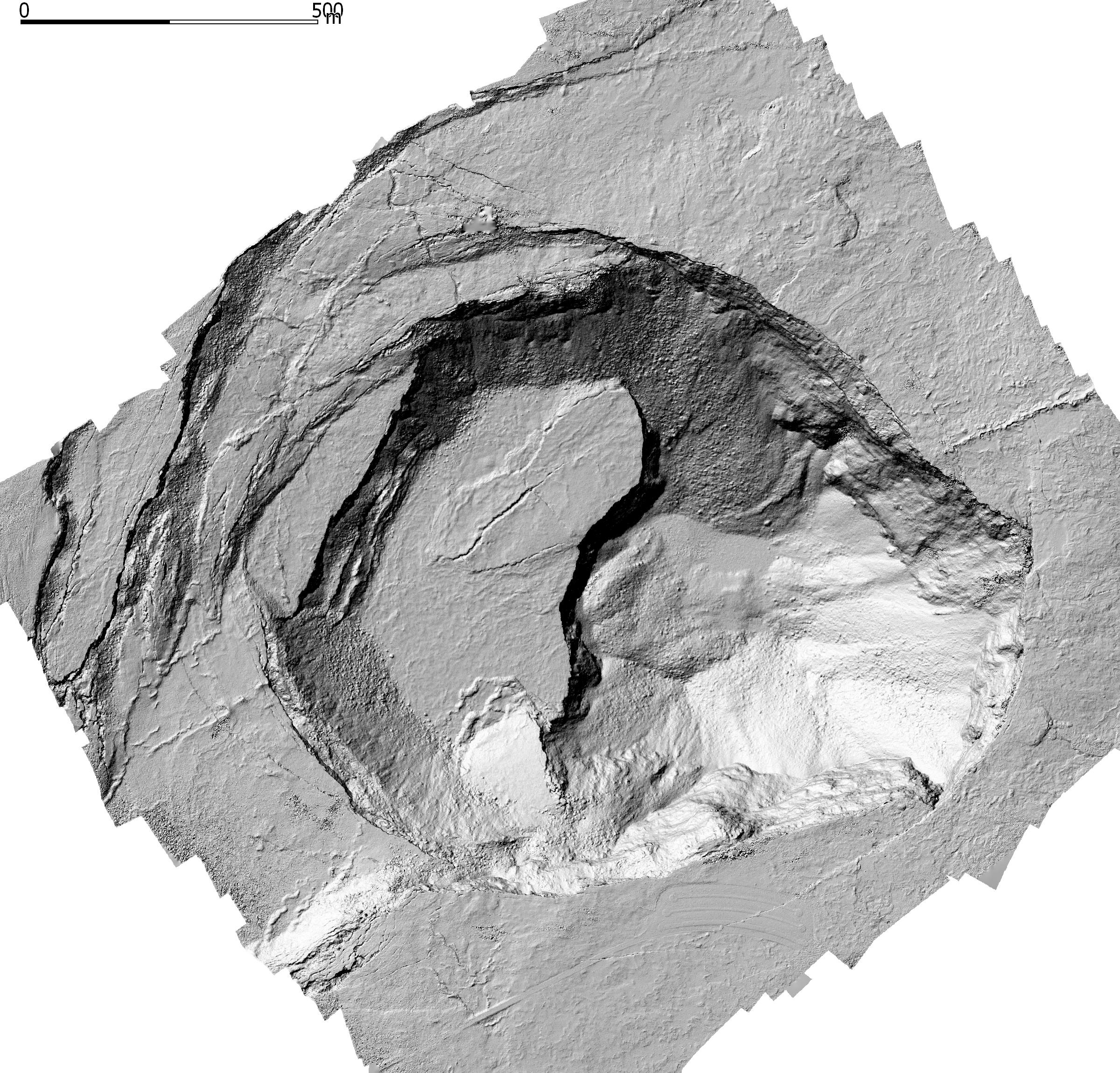
ABOVE: A photogrammetry survey of Kīlauea’s summit by the U.S. Department of Interior Unmanned Aircraft Systems’ (UAS) Kīlauea response team show the topography of Halema‘uma‘u as of June 8. Cracks through the former overlook parking lot (bottom of image) wrap around the east margin of Halema‘uma‘u; the once-popular overlook viewing area (closed since 2008 due to volcanic hazards associated with the former summit lava lake) has collapsed into the crater. New faulting and slumping are obvious on the crater’s west side (left). The depth of the crater has increased by roughly 250 meters (820 feet) since early May. Limited UAS flights into the summit area are conducted with permission and in coordination with Hawai‘i Volcanoes National Park to collect quantitative and qualitative data needed for updated hazard assessments, all of which are shared with emergency managers. Image courtesy of the U.S. Geological Survey and Office of Aviation Services, Department of the Interior, with support from the Hawaiian Volcano Observatory and Hawai‘i Volcanoes National Park.
Hawaiian Volcano Observatory reports that an explosive eruption at Kīlauea summit has occurred at 12:50 a.m. The resulting ash plume may affect the surrounding areas. The wind may carry the ash plume to the southwest toward Wood Valley, Pahala and Ocean View.
The danger from this eruption is ash fallout. The major response is to protect yourself from fallout.
If you are at home, stay indoors with the windows closed. Turn on your radio and listen for updates from authorities.
If you are in your car, keep the windows closed. Ash fallout may cause poor driving conditions, due to limited visibility and slippery driving conditions. Drive with extreme caution, or pull over and park.
After the hazard has passed, do check your home, and especially your catchment system for any impact that may affect your water quality.
Sunday, June 10, 2018, 10:26 p.m.: HVO update
Current Volcano Alert Level: WARNING
Current Aviation Color Code: RED
Kīlauea Volcano Lower East Rift Zone
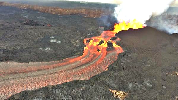
Fissure 8 continues to erupt vigorously, with lava streaming through a channel that reaches the ocean at Kapoho Bay. The width of the active part of the lava channel varies along its length, but ranges from about 100 to 300 yards wide. A clear view of the cinder-and-spatter cone that’s building around the vent from ongoing lava fountains can be seen here on June 10, 2018. PC: USGS
Vigorous eruption of lava continues from the lower East Rift Zone (LERZ) fissure system in the area of Leilani Estates.
The three closely spaced lava fountains at Fissure 8 are erupting with maximum heights reaching 150-180 feet. Lava continues to be fed into the channelized flow trending north and then east to the ocean entry at Kapoho. Very minor spillovers are occurring at multiple places along the channel but have uniformly been short lived and are not threatening areas that were not previously covered by lava. Gas emissions from the fissure eruption continue to be very high. The late afternoon overflight noted a vigorous plume rising from the ocean entry with minor steam explosions at the leading edge.
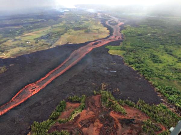
A closer view of the Fissure 8 lava channel with the cinder quarry more clearly visible in the foreground (bottom of photo) on June 10, 2018. During the morning overflight, HVO geologists observed no new breakouts of lava near this quarry. PC: USGS
Minor incandescence and lava activity at Fissures 16/18 is continuing but not feeding significant flows. No other fissure is showing activity at this time.
Pele’s hair and other lightweight volcanic glass from fountaining of Fissure 8 are falling downwind of the fissure and accumulating on the ground within Leilani Estates. High winds may waft lighter particles to greater distances. Residents are urged to minimize exposure to these volcanic particles, which can cause skin and eye irritation similar to volcanic ash.
HVO field crews are on site tracking the fountains, lava flows, and spattering from Fissure 8 as conditions allow and are reporting information to Hawaii County Civil Defense. Observations are also collected on a daily basis from cracks in the area of Highway 130; no changes in temperature, crack width, or gas emissions have been noted for several days.
Volcanic gas emissions remain very high from Fissure 8 eruptions. Yesterday, gas emissions were measured to be nearly twice the value measured during the past two weeks. Trade wind conditions are expected to bring vog to the south and west sides of the Island of Hawai‘i.
Overflows of the upper Fissure 8 lava channel the morning of June 10, 2018, sent small flows of lava down the levee walls. These overflows did not extend far from the channel, so they posed no immediate threat to nearby areas. Channel overflows, like the ones shown here, add layers of lava to the channel levees, increasing their height and thickness. PC: USGS
The ocean entry is a hazardous area. Venturing too close to an ocean entry on land or the ocean exposes you to flying debris from sudden explosive interaction between lava and water. Also, the lava delta is unstable because it is built on unconsolidated lava fragments and sand. This loose material can easily be eroded away by surf, causing the new land to become unsupported and slide into the sea. Additionally, the interaction of lava with the ocean creates “laze”, a corrosive seawater plume laden with hydrochloric acid and fine volcanic particles that can irritate the skin, eyes, and lungs.
Magma continues to be supplied to the lower East Rift Zone. Seismicity remains relatively low in the area with numerous small magnitude earthquakes and low amplitude background tremor. Higher amplitude tremor is occasionally being recorded on seismic stations close to the ocean entry.
Additional ground cracking and outbreaks of lava in the area of the active fissures are possible. Residents downslope of the region of fissures should heed all Hawaii County Civil Defense messages and warnings.
Kīlauea Volcano Summit
There have been no ash emissions since early this morning; however, seismicity at the summit is increasing. If the pattern observed before previous explosions persists, we expect another event in the next few hours. Inward slumping of the rim and walls of Halema`uma`u continues in response to ongoing subsidence at the summit.
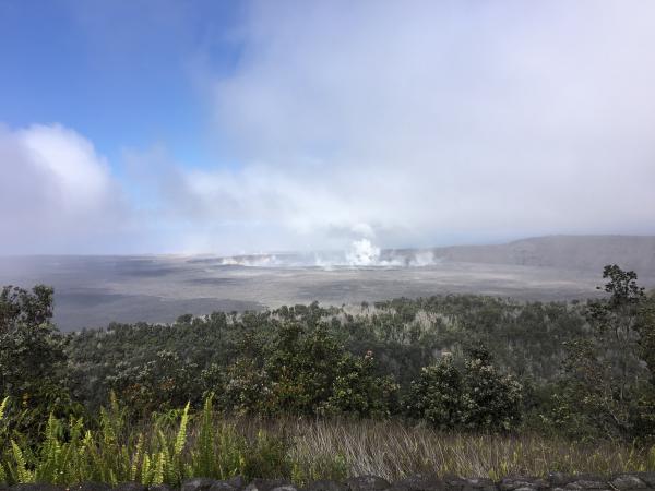
Another explosion occurred at Halema‘uma‘u at 12:51 a.m. on June 10, 2018, releasing energy equivalent to a magnitude-5.3 earthquake. Following the explosion, summit activity consisted mostly of passive degassing at Halema‘uma‘u, similar to what is shown in this image taken mid-morning. Seismicity at the summit decreased after the explosion, but has been increasing throughout the day. PC: USGS
Sulfur dioxide emissions from the volcano’s summit have dropped to levels that are about half those measured prior to the onset of the current episode of eruptive activity. This gas and minor amounts of ash are being transported downwind, with small bursts of ash and gas accompanying intermittent explosive activity.
For forecasts of where ash would fall under forecast wind conditions, please consult the Ash3D model output here.
Information on volcanic ash hazards and how to prepare for ash fall maybe found at http://www.ivhhn.org/information#ash (health impacts) OR https://volcanoes.usgs.gov/volcanic_ash/ (other impacts).
VIDEO: Three closely spaced lava fountains at Fissure 8 continue to feed a channelized flow trending north and then east to the ocean entry at Kapoho Bay. This video is from an HVO helicopter overflight of the braided lava channel this morning, June 11, 2018, around 6:30 a.m. Minor overflows of the channel levees have occurred at several places along the channel, but have been short-lived and do not pose an immediate threat to areas not previously covered by lava.
Sponsored Content


