

6:20 PM Update: Evacuations Happening NOW
This is a Civil Defense Message for Monday, May 28 at 6:00 in the evening.
Hawaiian Volcano Observatory reports that a fast moving pahoehoe flow from Fissure 8 is advancing on Nohea and Kupono Streets north of Leilani Street. There are reports of lava fountains on Moku Street. Anyone in the area, from Pomaikai east, needs to leave now.
Due to the volcanic activity, the following policies are in effect:
- Residents close to the active eruption need to leave the area to avoid being isolated by the flow.
- Authorities are going door to door on the affected streets.
- Stay alert for warnings from Civil Defense Officials
- The Pāhoa Community Center, Kea‘au Community Center, and Sure Foundation Church are open. The shelters are pet friendly.
This news story will be updated throughout the day as new information becomes available and new articles will be added to the website’s “News” section. Previous information about ongoing events can be found in Big Island Now’s “Volcano Blog” section.
Update, Monday May 28. 2018 at 6 p.m.: Civil Defense Press Briefing and U.S. Geological Survey
The following video was taken at the Hawai‘i County Civil Defense office on Monday, May 28, 2018, at 3 p.m.
In the video, Civil Defense Administrator Talmadge Magno explains the reason why Hawai‘i County Mayor Kim decided to allow the public to access Pohoiki Beach Park.
https://www.facebook.com/BigIslandNow/videos/1668855956525280/
USGS Report:
Vigorous eruption of lava continues from the lower East Rift Zone (LERZ) fissure system in the area of Leilani Estates and Lanipuna Gardens.
The lava flow from Fissure 8 reached Pohoiki Rd. this morning and stalled as the Fissure’s activity abruptly diminished. A few fissures reactivated briefly during the day. As of the 1 pm overflight, Fissure 8, 18, 20, 22, 6/13, and 7/21 reactivated with Fissure 7/21 having the highest fountains. The reactivated fissures have not yet erupted enough lava to reach the coast so the two ocean entry sites were relatively inactive. Only a minor ooze of residual lava was entering the ocean from the Eastern channel.
The most recent map of lava flows can be found here:
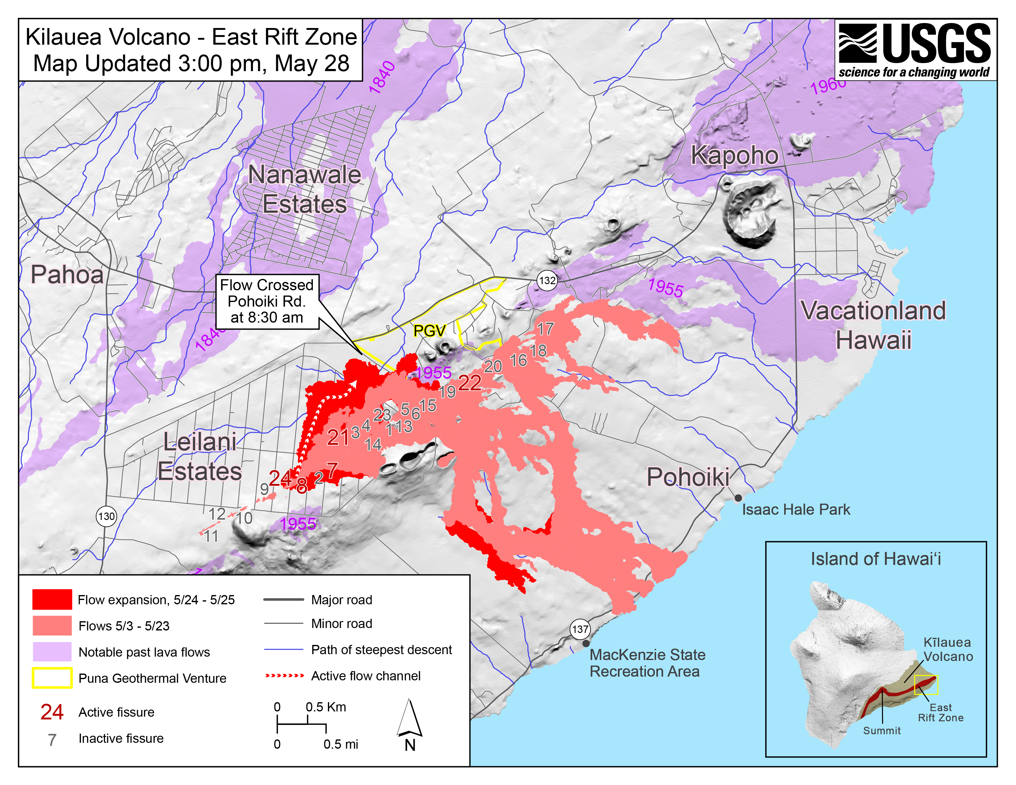
Map as of 3:00 p.m. HST, May 28, 2018. Shaded purple areas indicate lava flows erupted in 1840, 1955, 1960 and 2014-2015. (Click to enlarge)
HVO field crews are on site tracking the fountains, lava flows, and spattering from multiple fissures as conditions allow and reporting information to Hawaii County Civil Defense. Crews are also checking on the status of ground cracks on Highway 130.
Volcanic gas emissions remain very high from the fissure eruptions. If a forecast shift in wind direction occurs today, widespread vog could occur on the Island of Hawaii.
Magma continues to be supplied to the lower East Rift Zone. Earthquake locations have not moved farther downrift in the past few days and the number of located earthquakes remains low.
Kīlauea Volcano Summit
Ash continued to erupt intermittently from the vent within Halemaʻumaʻu crater, at Kīlauea’s summit. Winds have weakened and shifted in direction so that ash fall could occur in communities around the summit area.
Earthquakes in the summit region continue as the summit area subsides and adjusts to the withdrawal of magma.
Additional explosive events that could produce minor amounts of ash fall downwind are possible at any time. Volcanic gas emissions at the summit remain high.
For forecasts of where ash would fall under forecast wind conditons, please consult the Ash3D model output here: https://volcanoes.usgs.gov/observatories/hvo/activity_2018.html
Information on ash hazards and how to prepare for ashfall maybe found here: http://www.ivhhn.org/information#ash

This image shows radar data acquired by the European Space Agency’s Sentinel-1 satellite over Kīlauea Volcano on May 19 at 6:30 PM HST (left) compared to May 25 at 6:30 PM HST (right). The satellite transmits a radar signal toward the surface and measures the strength of the return, with bright areas indicating a strong return and dark areas a weak return. Strong returns indicate rough surfaces or slopes that point back at the radar, while weak returns come from smooth surfaces or slopes angled away from the radar. Comparing the two images shows that the summit eruptive vent continues to expand as the unsupported conduit walls collapse. As of the afternoon of May 25, the vent expansion included not only continued westward growth of the vent rim, but also a subsidiary pit on the north part of the floor of Halema‘uma‘u crater. The vent area is now approximately 90 acres, and we anticipate further enlargements over the coming days to weeks as subsidence of Kīlauea caldera, rockfalls, and small explosions continue.
Update, Monday, May 28, 2018 at 1:35 p.m.: Civil Defense and U.S. Geological Survey
The National Weather Service reports light easterly winds are expected to push volcanic gases westward. This includes increased ash and sulfur dioxide downwind of the Kīlauea summit and fissures on East Rift Zone. Leilani Estates has high levels of vog and sulfur dioxide.
Regarding upcoming meetings:
- An eruption community information meeting will be held at the Pāhoa High cafeteria on Tuesday, May 29 at 5 p.m.
- A second meeting to discuss increasing vog and ash exposure in the Ka‘ū District will be held at the Ka‘ū High School multi-purpose room on Wednesday, May 30 at 5:30 p.m.
HELCO reports that power interruptions are likely in the lower East Rift Zone. Due to the work in the area and the volcanic activity, the following is provided for your information:
- HELCO will be rerouting power to the Leilani Estates and the lower Puna areas starting at 3 p.m.
- Be aware of downed power lines. Always assume power lines are active and exercise extreme caution.
Aerial view of active lava flow crossing Pohoiki Road during an overflight this morning about 7 a.m. Pohoiki Road cuts through middle of photograph.

Click to enlarge
Note lava fountains erupting (top right) from fissure 8 (left-side fountain) and 24 (right-side fountain) from the fissure complex. By late this morning, the flow’s advance slowed to a few meters (yards) per hour, and fissure 8 activity had diminished significantly.
Close view of lava channel in middle of the lava flow erupting from fissure 8 during this morning’s overflight at about 7 a.m.

The tallest lava fountain is fissure 8, active since yesterday evening. The eruption rate at fissure 8 diminished significantly later in the morning.
Update Monday, May 28, 2018 at 11 a.m.: U.S. Geological Survey
USGS Hawaiian Volcano Observatory status of Kīlauea volcano in Hawaii on May 28, 2018. Summit photo courtesy of Civil Air Patrol.
Vigorous eruption of lava continues from the lower East Rift Zone (LERZ) fissure system in the area of Leilani Estates and Lanipuna Gardens.
Overnight, field crews confirmed that the fast-moving flow that broke out at about 7 p.m. Sunday night, May 27, 2018, originated from Fissure 8. The fissure fed a channelized flow that moved north along the margin of the existing flow before turning east and crossing out of Leilani Estates near the intersection of Kahukai and Hookupu streets. As of 8 a.m. Monday morning, May 28, it had started to cross Pohoiki Road, but the advance rate slowed from hundreds of meters (yards) per hour on Sunday night to a few meters (yards) per hour this morning.
Fissures 6/13 are inactive, and Fissure 9 is reactivated but erupting small amounts of lava that are pooling nearby. Fissure 7/21 are no longer active and lava flows from that fissure have largely stalled on PGV property.
The most recent map of lava flows can be found here: https://volcanoes.usgs.gov/volcanoes/kilauea/multimedia_maps.html
HVO field crews are on site tracking the fountains, lava flows, and spattering from multiple fissures as conditions allow and reporting information to Hawai‘i County Civil Defense. Crews are also checking on the status of ground cracks on Highway 130.
Volcanic gas emissions remain very high from the fissure eruptions. If a forecast shift in wind direction occurs today, widespread vog may be expected on the Island of Hawai‘i.
Magma continues to be supplied to the lower East Rift Zone. Earthquake locations have not moved farther downrift in the past few days and the number of located earthquakes remains low.
Kīlauea Volcano Summit
Ash continued to erupt intermittently from the vent within Halemaʻumaʻu crater, at Kīlauea’s summit. A brief emission event at about 4:35 a.m. Monday morning. May 28, sent ash to about 10,000 feet above sea level but was not associated with a significant tilt offset. A similar event at about 6:30 a.m. sent ash to approximately 12,000 feet above sea level. Earthquakes are currently occurring at high rates in the summit area. Observations from the ground, by UAS, and by satellite during the past week have documented retreat of the summit vent walls due to collapse of the steep conduit and rim. Trade winds are causing ash fall to the southwest. If a forecast shift in wind direction occurs today, ash fall may occur in communities around the summit area.
Earthquakes in the summit region continue as the summit area subsides and adjusts to the withdrawal of magma.
Additional explosive events that could produce minor amounts of ash fall downwind are possible at any time. Volcanic gas emissions at the summit remain high.
Update Monday, May 28, 2018, at 10 a.m.
The National Weather Service reports light easterly winds are expected to push volcanic gases westward. This includes increased ash and sulfur dioxide downwind of the Kīlauea summit and fissures on East Rift Zone.
The Hawaiian Volcano Observatory reports ash explosions continue. An ash explosion at Halema‘uma‘u crater pushed an ash cloud 13,000 feet into the air early this morning.

Aerial view of Kīlauea Volcano’s summit caldera and an ash plume billowing from Halema‘uma‘u, a crater within the caldera. The USGS–Hawaiian Volcano Observatory and Hawai‘i Volcanoes National Park’s Jaggar Museum are visible on the caldera rim (center right); Kīlauea Military Camp can be seen in the lower right. Photo courtesy of the Civil Air Patrol.
A community information meeting will be held Wednesday, May 30 at 5:30 in the evening at the Ka‘ū High School multi-purpose room to discuss the increasing vog and ash exposure in the Ka‘ū District.
Original Post:

Live Panorama of Lower East Rift Zone Camera from Lower East Rift Zone [PGcam]
Last Updated May 28, 2018 at 7:35 a.m.
Due to changing conditions, the following guidance is given:
- Take action to limit exposure to ash, volcanic gases, and VOG; be prepared to leave the area with little to no notice.
- Limit outside activities and exercise. Drink plenty of fluids.
- If you have breathing problems, stay indoors with the windows closed. If possible, use your air conditioner.
- Ash and VOG may decrease visibility, so adjust your driving to the conditions.
- Stay alert for notice of changing conditions.
- N-95 masks that were distributed are for ash particulate and do NOT protect from gasses or vapors, including SO2
U.S. Summary: Sunday, May 27, 2018, at 11:35 p.m:

Vigorous eruption of lava continues from the lower East Rift Zone (LERZ) fissure system in the area of Leilani Estates and Lanipuna Gardens.
Fissures 7 and 8 remain the most active eruptive centers of the system and have been feeding lava flows that have advanced northeast onto PGV property. At about 7:00 PM HST, a fast-moving lava flow broke from this area and advanced rapidly to the north and west through the eastern portion of Leilani Estates. Several residents were evacuated in advance of the dangerous and fast-moving flows.
Activity at Fissure 22 has waned, and Fissure 13 is the dominant source of lava entering the ocean, which is occurring at three minor entry points. Fountaining is occurring at Fissure 8.
HVO field crews are on site tracking the fountains, lava flows, and spattering from multiple fissures as conditions allow and reporting information to Hawai‘i County Civil Defense. Crews are also checking on the status of ground cracks on Highway 130.
Volcanic gas emissions remain very high from the fissure eruptions. Trade winds are weakening, and widespread vog is expected on the Island of Hawai‘i on Monday.
Magma continues to be supplied to the lower East Rift Zone. Earthquake locations have not moved farther downrift in the past few days and the number of located earthquakes remains low.
Sponsored Content


