Ash Plume Visible From Hilo
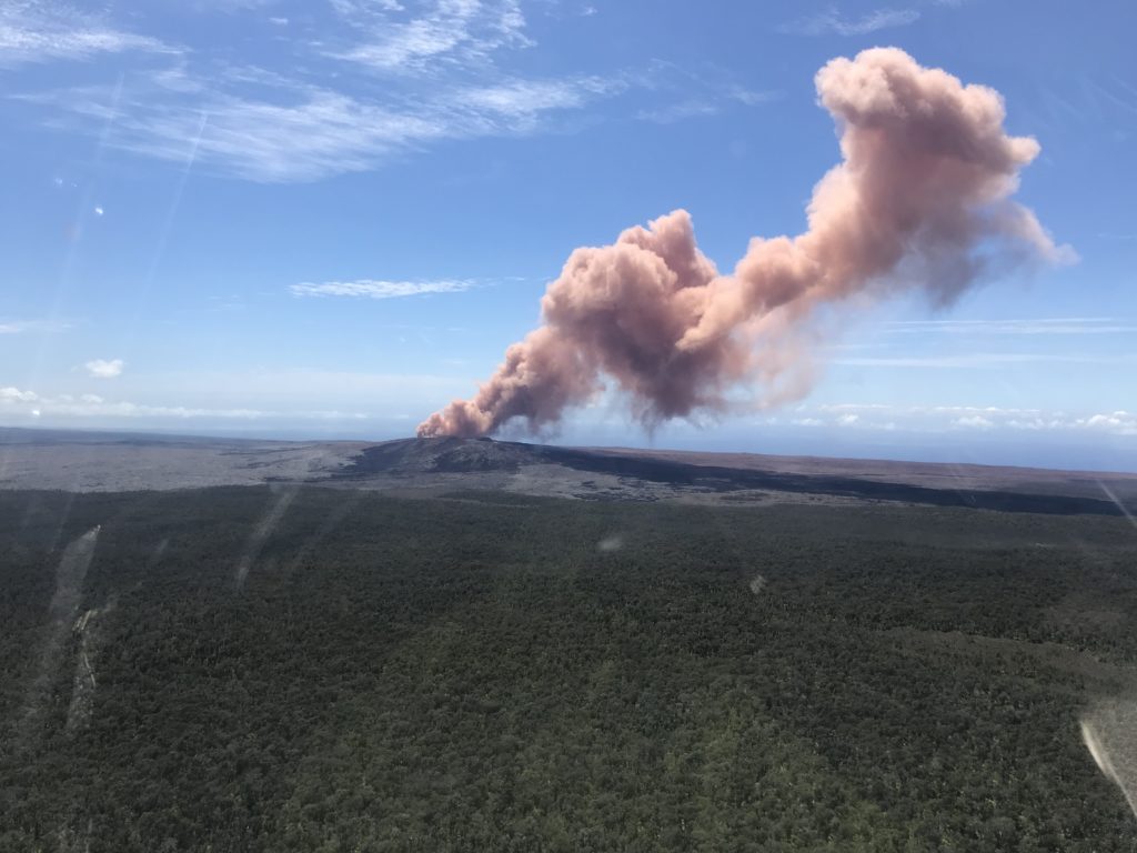
After the 5.0 magnitude earthquake reported in the Volcano area of the Big Island on Thursday, May 3, 2018, reports of a large ash plume started surfacing on social media sites. The ash plume was reported to be seen as far away as Hilo.
According to the United States Geological Survey (USGS), at 10:30 a.m., ground shaking from a magnitude-5.0 earthquake south of Pu‘u ‘Ō‘ō caused rockfalls and possibly additional collapse into the Pu‘u ‘Ō‘ō crater on Kīlauea Volcano’s East Rift Zone.

This image was captured from an HVO overflight carrying HVO scientists to the East Rift Zone for field work today. USGS photo by Kevan Kamibayashi.
A short-lived plume of ash produced by this event lofted skyward and dissipated as it drifted southwest from Pu‘u ‘Ō‘ō. Downwind areas may have experienced a dusting of ash from this plume. At this time, the 10:30 earthquake has caused no other changes at Kīlauea Volcano. HVO will continue to closely watch monitoring data for any changes.
Big Island Now drove around the Nananwale and Leilani Estates area of the Puna District today and spoke to residents who were preparing for a possible evacuation if need be.
One resident spoke about the fact that they didn’t really know what to do because they didn’t know where the lava would surface. Another resident was concerned for his dogs if he had to evacuate and didn’t have a plan for them yet.
For your further information, go to the following helpful links and contact numbers:
Updates Hawaiian Volcano Observatory Kilauea Activity Summary available here: https://volcanoes.usgs.gov/volcanoes/kilauea/status.html and by phone at (808) 967-8862. Subscribe to these messages: https://volcanoes.usgs.gov/vns2/
Recent Earthquakes in Hawai’i (map and list):
https://volcanoes.usgs.gov/hvo/earthquakes/
Lava viewing information:
Hawai‘i Volcanoes National Park: https://www.nps.gov/havo/planyourvisit/lava2.htm
County of Hawaii: http://www.hawaiicounty.gov/lava-viewing/
Kalapana lava-viewing area: 808-430-1966
Webcam images: https://volcanoes.usgs.gov/volcanoes/kilauea/multimedia_webcams.html
Photos/Video: https://volcanoes.usgs.gov/volcanoes/kilauea/multimedia_chronology.html
Lava Flow Maps: https://volcanoes.usgs.gov/volcanoes/kilauea/multimedia_maps.html
Definitions of terms used in update: https://volcanoes.usgs.gov/volcanoes/kilauea/extra/definitions.pdf
Overview of Kīlauea summit (Halemaʻumaʻu) and East Rift Zone (Puʻu ʻŌʻō ) eruptions:
https://volcanoes.usgs.gov/volcanoes/kilauea/extra/background.pdf
Summary of volcanic hazards from Kīlauea eruptions:
https://volcanoes.usgs.gov/volcanoes/kilauea/extra/hazards.pdf
Explanation of Volcano Alert Levels and Aviation Color Codes:
https://volcanoes.usgs.gov/activity/alertsystem/index.php
https://pubs.usgs.gov/fs/2006/3139/


