

Volcano Activity Update 7: Shallow Earthquake Activity Increases

Halemaʻumaʻu Overlook Vent Thermal image from Halemaʻumaʻu Overlook webcam, May 1, 2018, 4:30 p.m.
UPDATE 7, May 1, 2018, 4 p.m.
The Hawaiian Volcanoes Observatory reports increased shallow earthquake activity for Kilauea Volcano below Pu‘u ‘Ō’ō in Puna District.
This means an outbreak of lava in a new location could occur. While it is not possible to predict where an outbreak could occur, the area east of Pu‘u ‘Ō’ō is a possible location.
Due to the increased seismic activity, the following are issued:
Department of Parks and Recreation has shut down the lava viewing area in Kalapana due to the proximity to the increased hazardous activity.
Lower Puna area residents are advised to stay informed by signing up for civil defense messages and alert via text, email and RSS feed.
Hawaiian Volcanoes Observatories and Hawai‘i County Civil Defense will continuing to monitor the situation throughout the night.
Big Island Now will post updates as they become available.
VIDEO UPDATE 6: May 1, 12:50 p.m.
https://www.facebook.com/BigIslandNow/videos/1641214065956136/
Hawai‘i County Civil Defense Administrator Talmadge Magno spoke to Big Island Now about the island’s recent seismic and lava activity.
Seismicity and ground deformation started increasing at about 3 a.m. on Tuesday, May, 1, 2018, between Pu‘u ‘Ō’ō and Highway 130, and has now migrated beyond 130, he said.
The East Rift runs underground from Kīlauea Summit at Halemaumau all the way down to the ocean at Cape Kumakahi.
Magno asks Puna District residents to stay informed and encourages residents to sign up for civil defense messages and alert via text, email and RSS feed.
He advises Puna residents to prepare themselves—not just for this event—but for any natural disaster, with at least 14 days worth of supplies.
Magno warns visitors to stay off the Kalapana flow field, as a rift could open up any time above that area.
UPDATE 5, May 1, 2018, 11:05 a.m.
Area residents felt the effects of the recent seismic and lava activity.
“I got a Red Cross message this morning informing me of the deflation and saying [the quake was] 3 miles from Highway 130 and EOC (Emergency Operations Center) was activated at 5 a.m.,” said Keoni Delacruz Veloria, a Hilo resident.
“I felt a couple [tremors] around this morning and figured that is what was happening,” said Pāhoa resident Holly Povlsen Johnson. Looks like the biggest one [earthquake] is by the road that we take down toward Kalapana. Will be interesting if it keeps going to the east toward the red road along the ocean.”

This map shows recent changes to Kīlauea’s East Rift Zone lava flow field. The area of the active flow field as of March 14, 2018, is shown in pink, while widening and advancement of the active flow as of April 13 is shown in red. Older Puʻu ʻŌʻō lava flows (1983–2016) are shown in gray. The yellow line is the trace of the active lava tubes. The Kamokuna ocean entry is inactive. The blue lines over the Puʻu ʻŌʻō flow field are steepest-descent paths calculated from a 2013 digital elevation model (DEM), while the blue lines on the rest of the map are steepest-descent paths calculated from a 1983 DEM (for calculation details, see http://pubs.usgs.gov/of/2007/1264/). Steepest-descent path analysis is based on the assumption that the DEM perfectly represents the Earth’s surface. DEMs, however, are not perfect, so the blue lines on this map can be used to infer only approximate flow paths. The base map is a partly transparent 1:24,000-scale USGS digital topographic map draped over the 1983 10-m DEM.
UPDATE 4, May 1, from a report published by USGS HVO at 8:49 a.m.
Just after 2 p.m. HST today, April 30, 2018, a marked increase in seismicity and ground deformation (change in ground surface shape) began at Pu‘u ‘Ō’ō on Kīlauea Volcano’s East Rift Zone. A few minutes later, a thermal webcam (PTcam) located on the rim of the Pu‘u ‘Ō’ō crater showed the first of two episodes of crater floor collapse; the second collapse began at 3:20 p.m. and lasted about an hour.
Webcam views into the crater and surrounding area were frequently obscured by poor weather conditions. However, shortly after 4 p.m., the PTcam recorded images that were likely the signature of small explosions from the western side of the crater as the floor collapsed.

Uplited Puʻu ʻŌʻō floor, April 23, 2018. PC: USGS
At the time of this update 6 p.m., April 30, there was no evidence of new lava within the crater, seismicity remained elevated in the vicinity of Pu’u ‘Ō’ō, and ground deformation at Pu’u ‘Ō’ō had significantly slowed.
Kīlauea’s summit eruption has thus far not been affected by the afternoon’s activity at Pu‘u ‘Ō’ō.
USGS Hawaiian Volcano Observatory scientists continue to closely monitor Kīlauea’s East Rift Zone and summit. A helicopter overflight of Pu’u ‘Ō’ō and the 61g flow field is scheduled for early Tuesday, weather permitting.
HVO webcam images are posted online.
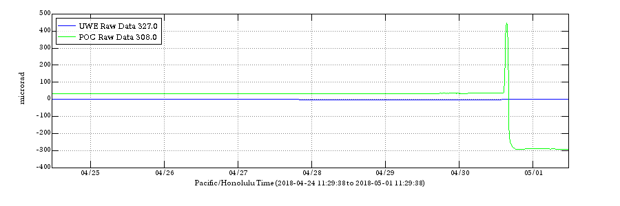
Electronic Tilt at Kīlauea Summit and East Rift Zone, April 25 to May 1, 2018. The blue line shows the radial tilt at Uwēkahuna (UWE), on the northwest rim of Kīlauea’s caldera. The green line is radial tilt at Pu‘u ‘Ō‘ō (POC), on the north flank of Pu‘u ‘Ō‘ō cone. These are recorded by continuously operating electronic tiltmeters. Positive changes often indicate inflation of the magma storage areas beneath the caldera or Pu‘u ‘Ō‘ō, but may also result from heavy rainfall or, occasionally, instrumental malfunctions. USGS graphic
Activity Summary: An intrusion of magma occurred overnight in the lower East Rift Zone extending from the general area of Puʻu ʻŌʻō eastward at least as far as Highway 130. As of 8:30 this morning, the level of activity has decreased significantly, but it is too soon to know if this is merely a pause. The intrusion began yesterday afternoon (April 30) associated with collapse of the Puʻu ʻŌʻō crater floor. The summit lava lake is unchanged and has risen overnight to just below the rim of the Overlook crater vent. Early this morning (May 1), HVO issued a Volcano Activity Notice calling attention to this intrusion and raising the possibility of a new outbreak along the rift zone if activity intensifies.
Residents of lower Puna should remain on alert and monitor Hawai‘i County Civil Defense messages.
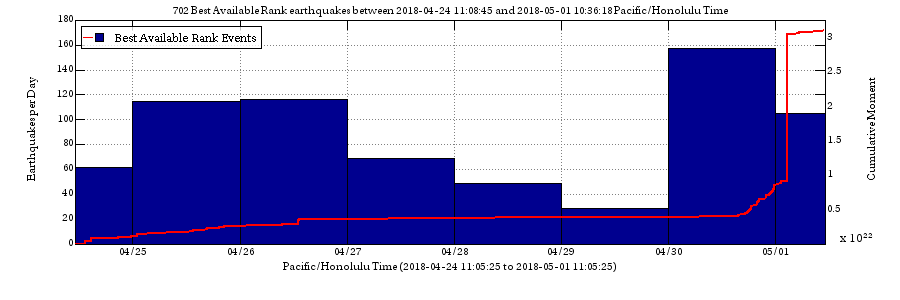
Number of earthquakes per day during the past week, April 25–May 1, 2018, indicated by (blue bars. The red line is the cumulative moment (energy) release. USGS graphic.
Summit Observations: The summit lava lake remains at a high level. Overall, the summit lava lake has shown no response to activity in the middle and lower East Rift Zone. Summit tiltmeters recorded very little change overnight. Tremor amplitude is fluctuating with lava lake spattering. Elevated summit sulfur dioxide emission rates persist.
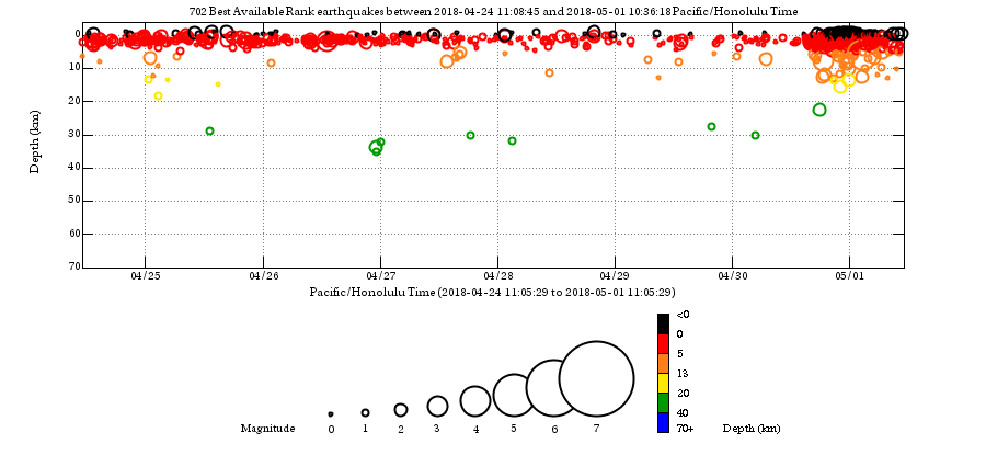
Depth of earthquakes during the past week (April 25–May 1, 2018) in the area shown on the map above. USGS graphic.
Puʻu ʻŌʻō Observations: HVO tiltmeters recorded sudden and dramatic changes accompanying the onset of crater floor collapse at Puʻu ʻŌʻō yesterday (April 30) between about 2 and 4 pm. Weather obscured web camera views of the crater, however thermal camera images showed the collapse in progress followed by emission of high temperature gases continuing into this morning. HVO field crews attempting to reach Puʻu ʻŌʻō this morning (May 1) were turned back by ash in the air above Puʻu ʻŌʻō, likely due to continuing collapse within the crater and vigorous gas emissions. Reddish ash was also noted in abundance on the ground around Puʻu ʻŌʻō. Seismicity remains elevated at Puʻu ʻŌʻō but tiltmeters near the cone show no significant deformation at this time.
Lava Flow Observations: There is no lava flow activity from the 61g lava flow on the coastal plain or pali and no lava is flowing into the ocean. Lava flow activity continues on the upper flow field, above the pali and closer to Puʻu ʻŌʻō, and does not pose a threat to nearby communities at this time. Areas of the upper flow field with active lava flows are located within the Kahaualeʻa Natural Area Reserve, which has been closed to the public by DLNR since 2007 due to volcanic hazards.
Webcam views of the flow field are available here.
Maps of the lava flow field can be found here.
For more information about the Kahaualeʻa NAR closure, go online.
Lava Flow Field and Ocean Entry Hazards: Hazards of active or recent lava flows include, but are not limited to: hot lava surfaces that can cause serious burns upon contact with unprotected or exposed skin; rough, uneven, and sharp terrain that can lead to falls, abrasions, lacerations and other injuries; high air temperature and humidity that can lead to dehydration or heat exhaustion; and steamy ground-fog produced by heavy rain falling (sometimes with little warning) on active or recent lava flows; this steam can severely limit visibility, can be acidic and should be avoided.
UPDATE 3, May 1, 10:30 a.m.
The collapse of the Puʻu ʻŌʻō crater floor on Kīlauea Volcano’s East Rift Zone has
triggered increases in earthquake activity and deformation along a large section of the rift zone, according to Christina Neal, scientist-in- charge at Hawai’i Volcanoes Observatory (HVO).
Neal said that seismicity was occurring as far east as Highway 130, and warned residents of lower Puna to remain alert and watch for further information about the status of the volcano at www.hawaiicounty.gov/active-alert.
“An outbreak of lava in a new location is one possible outcome,” Neal said. “At this time it is not possible to say with certainty if or where such an outbreak may occur, but the area downrift (east) of Puʻu ʻŌʻō is the most likely location, as this is where seismicity and deformation have been concentrated overnight.”
Meanwhile, Hawai‘i County has closed the Kalapana lava viewing area amid the possibility of an eruption, and security has been posted to ensure than no unauthorized persons enter the area.
“We don’t want people hiking in that area, which is downslope from the rift,” Parks and Recreation Deputy Director Maurice Messina said.
Messina said that vendors at the viewing area were told to vacate the area. He noted that the lava viewing area can draw 500 to more than 2,000 visitors, depending on the level of volcanic activity.
A magnitude 4.0 earthquake just offshore of Puʻu ʻŌʻō occurred at 2:39 a.m. Tuesday, May 1, 2018—the largest of a sequence of tremors along the rift zone.
There is no risk of tsunami at that magnitude.
Deformation is the term used to describe change in the surface of a volcano, such as swelling, sinking or cracking, which can be caused by movements in the Earth’s crust due to motion along faults, according to the U.S. Geological Survey.
UPDATE 2: May 1, 2018, 9:30 a.m.
This is a Civil Defense message for Tuesday morning, May 1, 2018 at 9:30.
The Hawaiian Volcanoes Observatory reports increased shallow earthquake activity in the Puna District below Kīlauea Volcano in the area between Puʻu ʻŌʻō and Highway 130.
This means an outbreak of lava in a new location could occur. While it is not possible to predict where an outbreak could occur, the area east of Puʻu ʻŌʻō is a possible location.
Due to the increased seismic activity, the following are issued:
The Hawai‘i County Department of Parks and Recreation has shut down the lava viewing area in Kalapana due to the proximity to the increased hazardous activity.
Lower Puna area residents are advised to stay informed by listening to the radio and Civil Defense text alerts and social media sites; this webpage will also be updated.
ORIGINAL POST, May 1, 7:54 a.m.
The Hawaiian Volcanoes Observatory reports increased shallow earthquake activity in the Puna District below Kīlauea Volcano in the area between Puʻu ʻŌʻō and Highway 130.
This means an outbreak of lava in a new location could occur.
While it is not possible to predict where an outbreak could occur, the area east of Puʻu ʻŌʻō is a possible location.
Due to the increased seismic activity, lower Puna area residents are advised to stay informed. Monitor Hawai‘i County Civil Defense messages here.

Just before 10 a.m. on Monday, April 30, 2018, a break in the weather allowed HVO’s webcam to capture this image of the lava lake within Halema‘uma‘u at the summit of Kīlauea. Following multiple overflows of the lava lake last week, the lake level dropped over the weekend in concert with the switch to summit deflation. Early on Monday morning, the lava lake level was estimated to be about 49 feet below the vent rim, but shortly thereafter, the summit switched to inflation, with the possibility of the lake level rising in the hours/days. Instead, HVO reported the collapse of the Puʻu ʻŌʻō crater floor Monday afternoon, April 30, 2018. PC: USGS
On Tuesday, May 1, 2018, at 4:54 a.m. HVO reported that a collapse of the Puʻu ʻŌʻō crater floor Monday afternoon, April 30, on Kīlauea Volcano’s East Rift Zone has prompted increases in seismicity and deformation along a large section of the rift zone, with seismicity currently occurring as far east as Highway 130.
A outbreak of lava in a new location is one possible outcome. At this time it is not possible to say with certainty if or where such an outbreak may occur, but the area downrift (east) of Puʻu ʻŌʻō is the most likely location, as this is where seismicity and deformation have been concentrated overnight.
Recent Observations
Between about 2 and 4:30 p.m. on April 30, following weeks of uplift and increasing lava levels within the cone, the crater floor at Pu’u ‘Ō’ō on Kīlauea Volcano’s East Rift Zone collapsed.
Poor weather prevented HVO from flying over the activity or seeing details of the activity in our web cameras on site.
Following the collapse, HVO seismometers and tiltmeters recorded an increase in seismic activity and deformation from Kīlauea Volcano’s summit to an area about 6 to 10 miles downrift (east) of Puʻu ʻŌʻō.
Overnight, this activity localized downrift of Puʻu ʻŌʻō and continued to propagate eastward along the rift zone.
The largest earthquake of this sequence so far was a magnitude 4.0 earthquake just offshore south of Pu’u ‘Ō’ō at 2:39 a.m. this mornin.
Kīlauea’s summit eruption has thus far not been affected by the change at Pu’u ‘Ō’ō.
Hazard Analysis
The migration of seismicity and deformation downrift (east) of Puʻu ʻŌʻō cone following Monday’s collapse indicates that a large area along the East Rift Zone is potentially at risk for a new outbreak.
The location of any future outbreak will determine what areas are in the path of new lava flows.
The situation is rapidly evolving and USGS Hawaiian Volcano Observatory scientists continue to closely monitor Kīlauea’s East Rift Zone and summit.
Hawaiian Volcanoes Observatories and Hawai‘i County Civil Defense are continuing to monitor the situation. More updates will be posted at BigIslandNow.com as information becomes available.
For more information, email askHVO@usgs.gov.
Sponsored Content


