

High Surf Advisory for Kona Side Today

Image: James Grenz
Alerts (as of 1:00 a.m.)
Small Craft Advisory: All Big Island coastal waters through 6 p.m. Monday.
High Wind Warning: Summit of Mauna Kea and Mauna Loa. Southwest “Kona” winds will increase reaching 50 to 60 mph in some spots with gusts up to 80 mph.
High Surf Advisory: West shores of Molokai through 6 p.m. Wednesday.
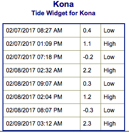
**Click directly on the images below to make them larger. Charts include: Big Island projected winds, tides, swell direction & period and expected wave heights.**
 Big Island Surf Forecast
Hilo side: Wave heights are forecast to be shoulder high to overhead today and building as the west-northwest fills in.
Kona side: Wave heights are expected to be knee/waist high today and building to about chest high later in the day.
South: Wave heights are expected to be knee/waist high today with the best breaks getting up to chest high by sunset.
 A new west-northwest is expected to fill in today peaking on Wednesday and holding through Thursday morning before beginning to fade back out.
Another storm is expected to develop that will generate a swell for the upcoming weekend.
Nothing significant expected out of the South Pacific any time soon. Southwest wind chop is down to leftovers.
Keep in mind, surf heights are measured on the face of the wave from trough to crest. Heights vary from beach to beach, and at the same beach, from break to break.
**Click here for your detailed Big Island weather report.**
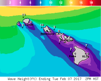
Image: NOAA
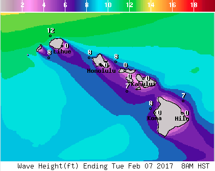
Image: NOAA

Image: NOAA
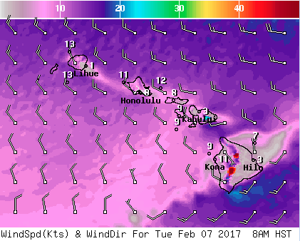
Image: NOAA

Image: NOAA
Sponsored Content


