

Forecast: Winds Still Breezy, Weaken Later Today

Image: James Grenz
Alerts (as of 1:00 a.m.)
High Surf Advisory: East shores of Big Island through 6 p.m. Monday.
Small Craft Advisory: All coastal waters and channels through 6 p.m. Monday.
**Click directly on the images below to make them larger. Charts include: Big Island high/low forecasted temperatures, projected winds, chance of cloud cover, projected localized weather conditions, vog/SO2 forecast and expected wave heights.**
Looking Ahead
Winds over the islands will begin to weaken today. Moderate trade winds are forecast through mid-week. Clouds and showers will focus over our usual windward and mauka areas during this time. Later in the week, light winds and dry weather are forecast. A band of showers along a new front is expected to move across the islands next weekend. Trade winds should return early next week behind the front.
Today
We have northeast winds today from 15 to 25 mph with higher gusts. High temperatures are forecast from 77° to 82°. Mostly cloudy skies are forecast for windward and mauka spots with frequent showers. Partly sunny skies for the Kona side with some clouds building in the afternoon and scattered showers.
UV index at 7 (“very high” exposure level)
Tonight
East winds are forecast around 15 mph tonight. Mostly cloudy with frequent windward showers and mostly cloudy with scattered showers in the evening for the Kona side and partial clearing as the night goes on. Low temperatures from 66° to 71°.
Our Big Island Now Weather homepage always includes daily: Sunrise | Sunset | Moonrise | Moonset | Moon Phase | Live Weather Cams | 5-day Forecast | Current Temperature & Conditions
**Click here for your detailed Big Island surf report.**

Image: NOAA

Image: NOAA

Image: NOAA

Image: NOAA

Image: NOAA

Image: NOAA
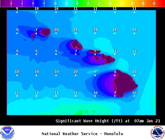
Image: NOAA

Image: NOAA
Sponsored Content


