Researchers Detect Large-Scale Motion at San Andreas Fault

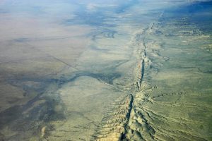
Aerial view of San Andreas Fault in the Carrizo Plain, 8,500 ft. altitude. Credit: Ikluft/Wikimedia.
A research group at the University of Hawaiʻi was part of a team that has identified large-scale motion around the San Andreas Fault in Southern California.
Motion was previously predicted in models; however, until now, it wasn’t actually documented.
Using an array of GPS instruments, researchers have detected “constant motion of the Earth’s crust–sometimes large, sudden motion during an earthquake and often subtle, creeping motion,” according to information released by the UH.
The new findings were also published on June 20 in Nature Geoscience.
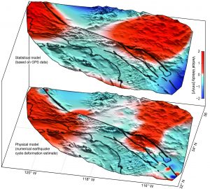
“Horizontal interseismic motions of the fault system are largely predictable, but vertical motions arising from tectonic sources remain enigmatic,” the publication notes. In the study, researchers say GPS data exposes a “coherent pattern of uplift and subsidence straddling the fault system.”

Uplift (red) and subsidence (blue) around the San Andreas Fault System based on GPS data (top) confirms motion predicted by previous models (bottom). Credit: Howell et al., 2016.
Researchers from UH-Mānoa, joined fellow researchers with the University of Washington and Scripps Institution of Oceanography in the discovery.
“Understanding this critical component of interseismic deformation at a complex strike–slip plate boundary will better constrain regional mechanics and crustal rheology, improving the quantification of seismic hazards in southern California and beyond,” according to the Nature Geoscience publication.
“While the San Andreas GPS data has been publicly available for more than a decade, the vertical component of the measurements had largely been ignored in tectonic investigations because of difficulties in interpreting the noisy data. Using this technique, we were able to break down the noisy signals to isolate a simple vertical motion pattern that curiously straddled the San Andreas fault,” said Samuel Howell, doctoral candidate at the UHM School of Ocean and Earth Science and Technology and lead author of the study in a university press release.
“UH reports that the “pattern resulting from their data analysis was reportedly similar in magnitude and direction to motions predicted by previously published earthquake cycle model results led by co-authors Bridget Smith-Konter, an associate professor at UHM SOEST, and David Sandwell, a professor at SIO.”
“We were surprised and thrilled when this statistical method produced a coherent velocity field similar to the one predicted by our physical earthquake cycle models,” said Smith-Konter in a university press release. “The powerful combination of a priori model predictions and a unique analysis of vertical GPS data led us to confirm that the buildup of century-long earthquake cycle forces within the crust are a dominant source of the observed vertical motion signal.”


