

Trade Winds Filling Back in Today

Image: James Grenz
Alerts (as of 1:00 a.m.)
A Small Craft Advisory is posted through 6 a.m. Wednesday for windward coastal waters of the Big Island.
**Click directly on the images below to make them larger. Charts include: Big Island high/low forecasted temperatures, projected winds, chance of cloud cover, projected localized weather conditions, vog/SO2 forecast and expected wave heights.**
Looking Ahead
Moderate trade winds will rebuild through Tuesday, focusing low clouds and showers mainly across windward and mauka areas. The winds will weaken over the smaller islands starting Wednesday, leading to a local afternoon sea breeze and nighttime land breeze weather pattern with isolated showers favoring the afternoon hours. A cold front will sweep down the island chain on Saturday and Saturday night, with strong and gusty northerly winds bringing cooler and drier air into the state.
Today
Today we expect partly sunny skies with isolated showers in the afternoon for the Kona side. Windward and mauka areas will get scattered showers. Winds are out of the east up to 15 mph. High temperatures from 79° to 84°.
UV index at 8 (“very high” exposure level)
Tonight
East winds are expected up to 15 mph tonight. Low temperatures from 68° to 73°. Scattered showers are likely for windward areas with isolated leeward showers in the forecast.
Our Big Island Now Weather homepage always includes daily: Sunrise | Sunset | Moonrise | Moonset | Moon Phase | Live Weather Cams | 5-day Forecast | Current Temperature & Conditions
**Click here for your detailed Big Island surf report.**

Image: NOAA / NWS

Image: NOAA / NWS
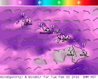
Image: NOAA / NWS
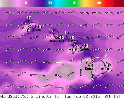
Image: NOAA / NWS
Image: NOAA / NWS

Image: NOAA / NWS
Sponsored Content


