

VOLCANO WATCH: A Geologic Tour of the Hawaiian islands (Oahu)
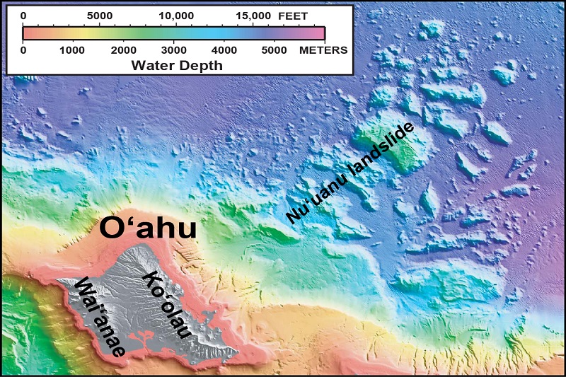
In this shaded relief and bathymetric map of O‘ahu, which comprises two volcanoes (Waiʻanae and Koʻolau), colors indicate water depth, from shallow (orange and yellow) to deep (purple), with shades of gray indicating the island area above sea level. From: U.S. Geological Survey Geologic Investigations Series Map I-2809, “Hawaiʻi’s Volcanoes Revealed”.
January is Volcano Awareness Month, during which our “Volcano Watch” articles are exploring the geology of the Hawaiian Islands. The series continues this week with a look at Oʻahu.
The island of Oʻahu is composed of two volcanoes. Waiʻanae, the western and older of the two, started growing from the sea floor around 4 million years ago. The birth of Koʻolau, which forms the east side of the island, probably occurred a few hundred thousand years later.
At Waiʻanae, shield-building volcanism—the most active time of a Hawaiian volcano’s life—ended by about 3 million years ago and was followed by a brief, about 200,000-year-long, period of post-shield volcanism. Since then, erosion has carved steep cliffs and valleys on the volcano. While some of this erosion has been caused by water, catastrophic collapses of the island have also occurred, some of which shed debris north onto the ocean floor across a distance of 110 km (70 mi)!
Koʻolau, on the other hand, was vigorously active until about 1.8 million years ago. Like Waiʻanae, Koʻolau has also been extensively eroded and has been the source of multiple huge landslides. In fact, Nuʻuanu Pali may be the erosional trace of the scarp that marks one of the largest landslides in the world. The gigantic Nuʻuanu slide extends across the ocean floor about 200 km (120 mi) northeast from Oʻahu , and one of the blocks of debris in the submarine landslide measures over 29 km (18 mi) long and 1.6 km (1 mi) thick!
The extensive erosion of Koʻolau has afforded geologists an unparalleled opportunity to view the interior of a Hawaiian volcano. For example, investigations of ancient lava flows reveal that Koʻolau’s caldera is located in the Kailua area, and that the caldera continued to subside even after eruptions had ended (perhaps pulled downward by the weight of the solidified magma chamber).
Even more spectacular are the swarms of dikes—solidified sheet-like or tabular intrusions of magma—that define the volcano’s rift zones, parallel to the crest of the current Koʻolau Range. In some places, over half the rock is made up of these dikes. The exposures of Koʻolau’s rift zone provide a sense of what Kīlauea’s current East Rift Zone must look like about 1 km (0.6 mi) beneath the surface. Studying Koʻolau therefore provides insights into how active Hawaiian volcanoes work.
Koʻolau also hosts extensive rejuvenated volcanism, which marks the final stage of a Hawaiian volcano’s eruptive life—essentially a weak sputtering before the volcano goes extinct.
Rejuvenated eruptions on Koʻolau followed a pause of about 1 million years after shield-building ended. About 40 discrete eruption sites are preserved across the east side of O‘ahu, including several extinct cinder cones that are now famous landmarks: Punchbowl, Tantalus, and Lēʻahi (Diamond Head). The youngest of these rejuvenated eruption sites include Koko Crater, Hanauma Bay, and Tantalus, which formed about 70,000–100,000 years ago. Lēʻahi and Punchbowl are about 400,000–500,000 years old.
As on Kauaʻi (the focus of last week’s “Volcano Watch”), future rejuvenated eruptions on Oʻahu are a possibility. Such eruptions could be hazardous, given that they would probably be at least mildly explosive, especially if they occur near the coast where magma and seawater can interact. The odds are remote, however, of such eruptions occurring during our lifetimes, or even those of many future generations.
Next week we’ll explore Maui, Lānaʻi, Molokaʻi, and Kahoʻolawe, all of which once stood above sea level as a single island with several volcanoes.
In the meantime, we hope to see you at one or more Volcano Awareness Month talks offered by USGS Hawaiian Volcano Observatory scientists around the Island of Hawai‘i. This week’s schedule includes presentations at Lyman Museum on January 18, Hawai‘i Volcanoes National Park on January 19, Makaʻeo Pavilion (Old Kona Airport State Park) on January 20, and Pāhoa on January 21.
Volcano Activity Updates
Kilauea continues to erupt at its summit and East Rift Zone. During the past week, the summit lava lake level varied between about 29 and 41 m (95–135 ft) below the vent rim within Halema‘uma‘u Crater. On the East Rift Zone, scattered lava flow activity remained within about 6 km (4 mi) of Puʻu ʻŌʻō.
Mauna Loa is not erupting. Seismicity remains elevated above long term background levels. In the last week, earthquakes occurred mostly beneath Mauna Loa’s upper Southwest Rift Zone at depths less than 5 km (3 mi). GPS measurements continue to show deformation related to inflation of magma reservoirs beneath the summit and upper Southwest Rift Zone of Mauna Loa.
One earthquake was reported felt on the Island of Hawai‘i this past week. On Wednesday, January 13, at 1:27 p.m., HST, a magnitude-3.3 earthquake occurred 10.8 km (6.7 mi) west of Kalapana at a depth of 8.0 km (4.9 mi).
Volcano Watch is a weekly article and activity update written by scientists at the U.S. Geological Survey`s Hawaiian Volcano Observatory.
Sponsored Content


