

Flash Flood Watch Still in Effect, Today’s Forecast
Alerts
A Flash Flood Watch is in effect for the Big Island and posted through 6:00 a.m. Saturday. Abundant moisture from weakening Hilda is expected to produce the potential for excessive runoff, rock/mudslides and fast-moving water that could create life-threatening situations. Additional rainfall amounts of 3 to 6 inches are possible in some areas. For windward and Kau areas, the rains are expected to taper off on Friday but locally heavy afternoon and evening thundershowers are expected again over interior slopes.
A Small Craft Advisory is posted for all Big Island coastal waters through 6:00 p.m. Friday for winds up to 30 knots and rough seas up to 11 feet. Inexperienced mariners should avoid navigating in these conditions.
**Click directly on the images below to make them larger. Charts include: Big Island high/low forecasted temperatures, projected winds, chance of cloud cover, projected localized weather conditions, vog/SO2 forecast and expected wave heights.**
Today
We expect high temperatures from 84° to 89°. Northeast winds are expected from 10 to 20 mph in exposed areas. Partly to mostly cloudy skies are forecasted with frequent windward showers and possible heavy rain and thunderstorms. The threat for heavy rain and thunderstorms will go down as time passes and Hilda continues to distance itself from the islands. Leeward spots are expected to get showers mainly in the afternoon and evening. Thunderstorms are also expected during that time.
UV index at 12 (“extreme” exposure level)
Tonight
As the night goes on heavy rain, cloud cover and possible thunderstorms on the leeward side will begin to dissipate. Windward areas are also expected to get rain and the possibility of heavy rain and thunderstorms, the threat of which will decrease as time passes. Northeast winds are forecasted from 10 to 20 mph in exposed areas. Low temperatures from 73° to 78° are expected.
Looking Ahead
A very moist air mass left over from Hilda will continue to encourage locally heavy rain across most of the state, and especially the Big Island, into the weekend. The areas affected should shrink with time. Trade winds will persist through this time. By early next week, a trough will bring an even moister air mass, and light winds.
Our Big Island Now Weather homepage always includes daily: Sunrise | Sunset | Moonrise | Moonset | Moon Phase | Live Weather Cams | 5-day Forecast | Current Temperature & Conditions
**Click here for your detailed Big Island surf report.**

Image: NOAA / NWS

Image: NOAA / NWS

Image: NOAA / NWS

Image: NOAA / NWS
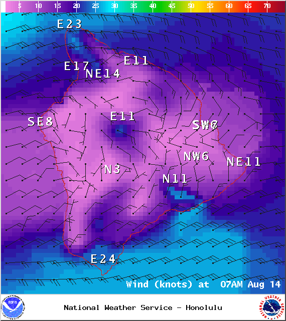
Image: NOAA / NWS
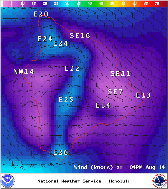
Image: NOAA / NWS
Image: NOAA / NWS
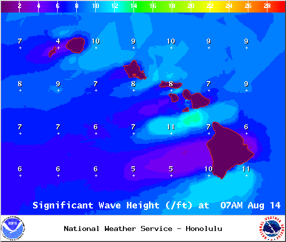
Image: NOAA / NWS
Sponsored Content


