

Front Expected This Weekend
Alerts
A High Wind Warning is posted for the summits of Mauna Kea and Mauna Loa through 6:00 a.m. Sunday. West winds from 55 to 90 mph are expected with gusts over 105 mph. High winds make driving dangerous. Please delay travel to the summit areas until the wind subsides.
A Wind Advisory is posted through 6:00 p.m. Saturday. Southwest winds from 20 to 35 mph are expected with gusts over 50 mph. Winds mainly affecting northeast terrain of the Big Island, especially north and east of mountains. The National Weather Service advises that winds this strong can bring down tree branches and make driving difficult. Use extra caution when driving and be careful when opening and closing doors. If camping in the area, be sure your tent is well anchored.
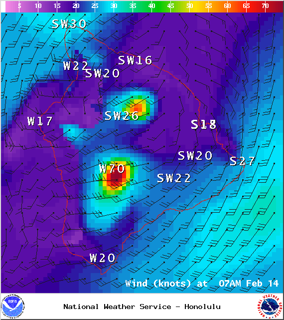
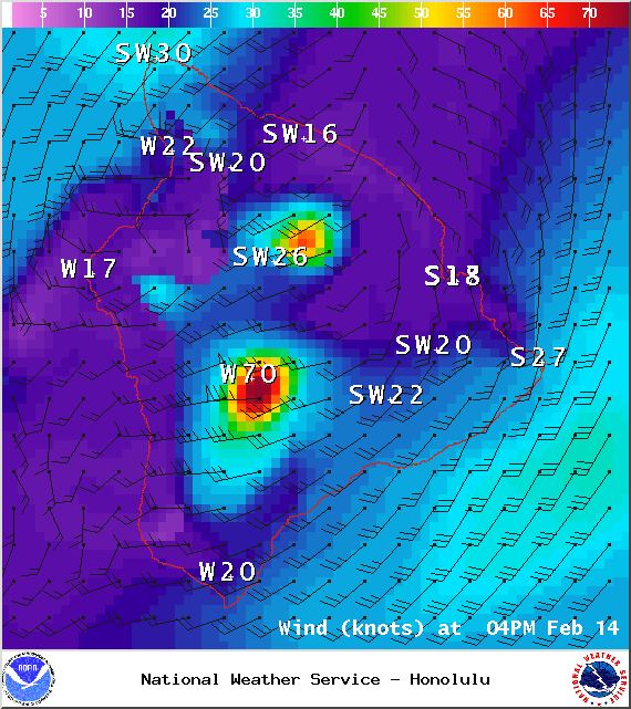
A Small Craft Advisory is posted for all Big Island waters through 6:00 p.m. Saturday for southwest winds from 30 to 35 knots with gusts to 50 knots and rough seas of 10 to 14 feet. Inexperienced mariners should avoid navigating in these conditions.
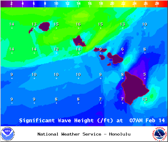
A High Surf Advisory is in effect for the south and west facing shores (6 to 8 foot faces) from 6:00 a.m. Saturday through 6:00 a.m. Sunday. Expect strong breaking waves, shore break and strong longshore and rip currents making swimming difficult and dangerous.
A Gale Warning is posted for all off shore waters.
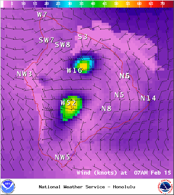
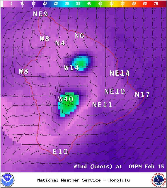
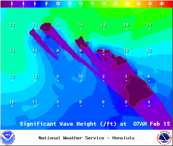
**Click directly on the images below to make them larger. Charts include: Big Island high/low forecasted temperatures, projected winds, chance of cloud cover, projected localized weather conditions, vog/SO2 forecast and expected wave heights.**
Today
Partly cloudy skies are expected today with isolated passing showers. Southwest to west winds from 15 to 30 mph are forecasted, gusting to 50 mph in some areas. High temperatures should fall in the range of 83° to 88°.
UV index at 6 (“high” exposure level)
Tonight
Clouds are expected to increase tonight with scattered showers. Gusty southwest winds will shift out of the northwest and gradually slow in speed to 10 to 20 mph. Low temperatures from 73° to 78° are expected.
Next New Moon: 1:47 p.m. on Feb. 18
Next Full Moon: 8:06 a.m. on Mar. 5
Sunday
Partly cloudy skies are expected with scattered morning showers for windward spots, clearing in the afternoon. Locally breezy winds out of the north to northwest from 10 to 25 mph. High temperatures from 80° to 85° and low temperatures from 67° to 72°.
Looking Ahead
A cold front will move across the islands bringing strong and gusty southwest winds especially north and east of the mountains. The front is expected to weaken by the time it reaches the Big Island Saturday night and early Sunday, with winds decreasing significantly and turning to a more northerly flow in the wake of the front. Cooler and drier conditions will establish across the islands by late Sunday and into early next week.
Our Big Island Now Weather homepage always includes daily: Sunrise | Sunset | Moonrise | Moonset | Moon Phase | Live Weather Cams | 5-day Forecast | Current Temperature & Conditions
**Click here for your detailed Big Island surf report.**

Saturday / Image: NOAA / NWS

Saturday / Image: NOAA / NWS

Saturday / Image: NOAA / NWS

Saturday / Image: NOAA / NWS
Saturday / Image: NOAA / NWS
Saturday / Image: NOAA / NWS

Saturday / Image: UHSOEST
Saturday / Image: NOAA / NWS
Saturday / Image: NOAA / NWS

Sunday / Image: NOAA / NWS

Sunday / Image: NOAA / NWS

Sunday / Image: NOAA / NWS

Sunday / Image: NOAA / NWS
Sunday / Image: NOAA / NWS
Sunday / Image: NOAA / NWS
Sunday / Image: NOAA / NWS
Sponsored Content


