

High Surf Warning & Harbor Surges Expected Today
Alerts
The High Surf Warning has been cancelled.
A High Surf Advisory replaces the Warning and is in effect through Thursday at 6 p.m. for surf of 8 to 13 feet along east-facing shores. Impacts include strong breaking waves, shore break and strong currents making swimming difficult and dangerous.
The Small Craft Advisory has been extended for all Big Island waters until Thursday at 6 p.m. Winds of 25 knots are expected and rough seas up to 13 feet. Inexperienced mariners should avoid navigating in these conditions.
A Marine Weather Statement is posted for Hilo harbor and other east-facing harbors across Maui County due to the large northeast swell. Navigating harbor entrances could be difficult and dangerous. Moderate surges and large breaking waves are expected near harbor entrances. Mariners should exercise extreme caution when operating vessels inside harbors or near entrances.
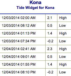
**Click directly on the images below to make them larger. Charts include: Big Island projected winds, tides, swell direction & period and expected wave heights.**
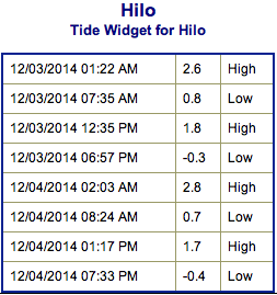 Big Island Surf Forecast, Wednesday December 3
Hilo side: Surf is expected head high to well overhead. The best breaks and exposures could see waves reach double to even triple overhead.
Kona side: Surf is expected shoulder to head high for the best exposures.
South: Southeast shores open to the trade swell could see waves knee to shoulder high, though sloppy and choppy conditions are expected. Minimal surf out of the southern hemisphere – knee high or less. Some wrap from the west-northwest swell as well.
Trade winds are generating swell for windward spots on the Big Island. Conditions will be choppy and sloppy.
 Buoy 51000 was reporting a 12 foot swell with a 15 second period last night. This swell built over night to warning levels for the northeast shores of the Big Island. The swell is expected to peak Wednesday and begin to fade, dropping back to advisory levels tomorrow.
Our current west-northwest swell is expected to shift today into Thursday and will swing some it’s energy away from the Kona coast and toward northwest exposures. Slowly fading into the end of the work week.
A new north-northwest swell is expected to build Friday into Saturday, peaking near advisory levels. Surf expected from overhead to well overhead, maybe even bigger at the best exposures. A new north-northwest swell is also expected for the weekend and a series of swells beyond that.
Super small trace amounts of swell expected out of the SPAC. Not much to get excited about.
Keep in mind, surf heights are measured on the face of the wave from trough to crest. Heights vary from beach to beach, and at the same beach, from break to break.
**Click here for your detailed Big Island weather report.**
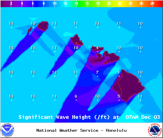
Image: NOAA / NWS
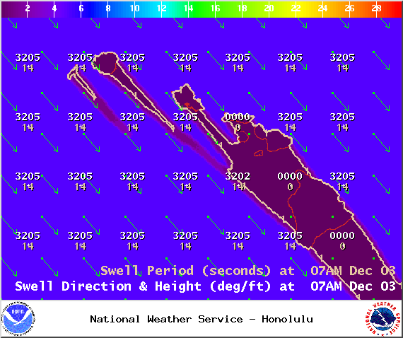
Image: NOAA / NWS
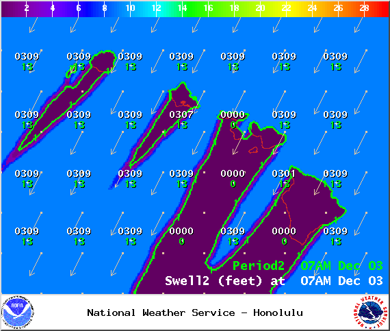
Image: NOAA / NWS
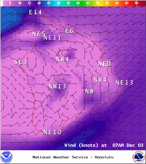
Image: NOAA / NWS
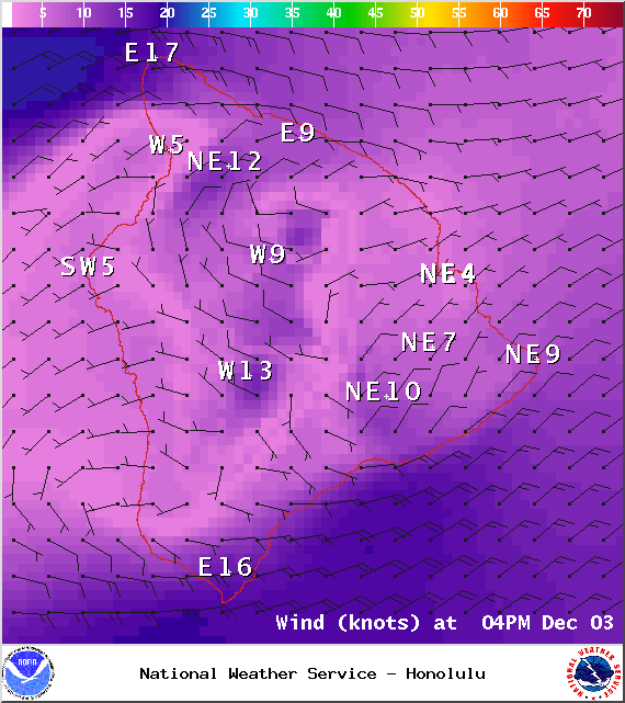
Image: NOAA / NWS
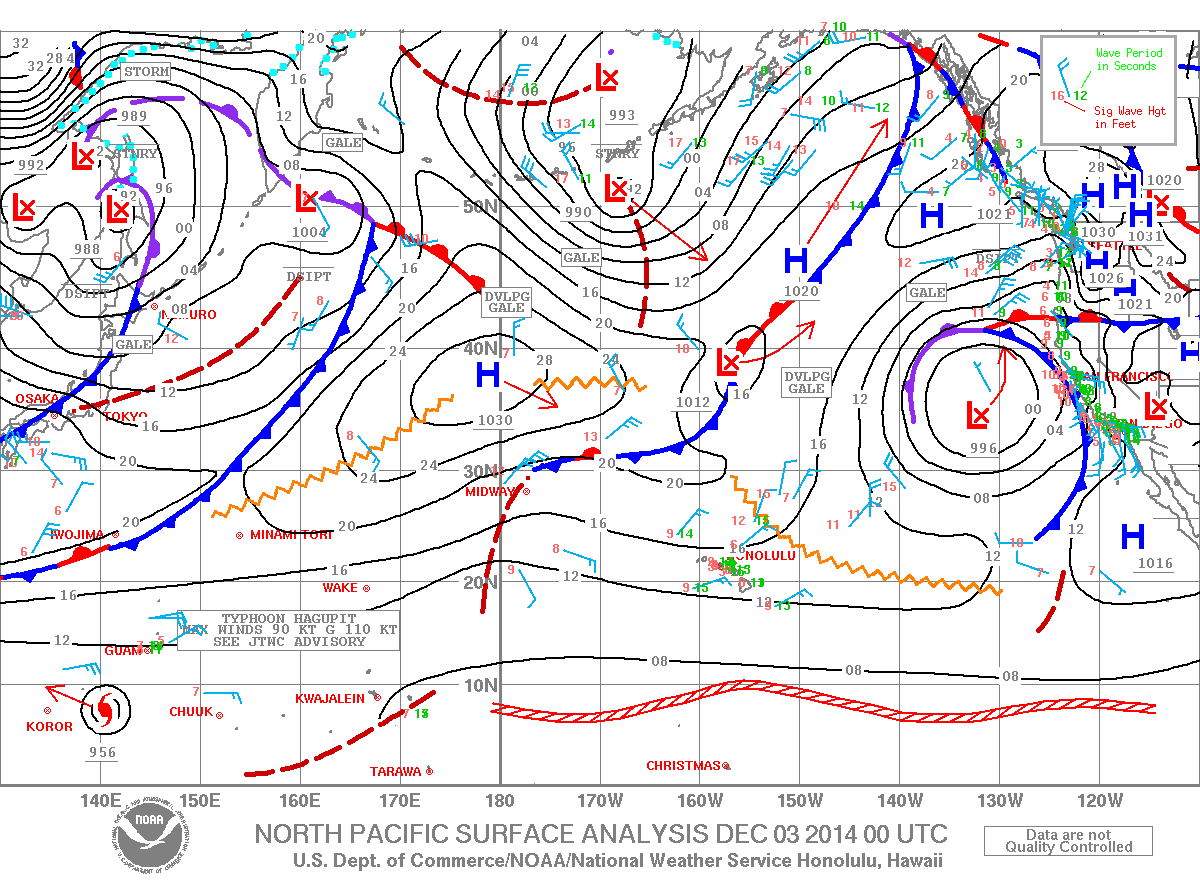
Image: NOAA / NWS
Sponsored Content


