

Malika Dudley’s Big Island Forecast (10/25/14)
**A breakdown of expected conditions specific to the Big Island is presented below in graphical form. High and low temperatures, swell, percent chance of clouds / rain and wind conditions are each depicted. All graphics are provided by the National Weather Service in Honolulu.**
Alerts
There are no alerts posted for Hawai’i County at this time, however we did tie a record high temperature in Hilo yesterday. Normal for this time of year is 82°. We hit 87° on the thermometer yesterday, a departure of 4° from normal. That tied the old record of 87° that was last set in 2003.
 Today
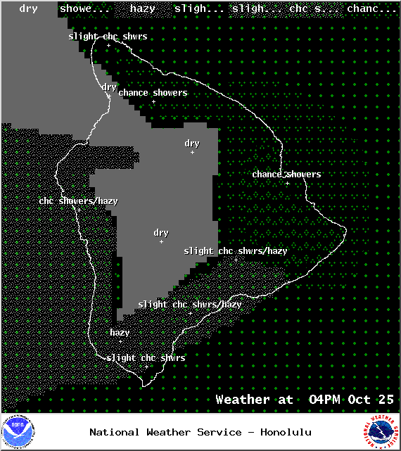
Today
We expect partly cloudy skies for the Big Island with showers likely along the Hamakua coastline. Areas from Kohala to Puna could get 1/4 to 1/2 inch of rain. Chance of rainfall is slightly lower for the Ka’u coastline with models showing less than 1/4″ expected. There’s also a chance of showers for leeward areas if showers drift over from the windward side. That old front we’ve been talking about is expected late Saturday into early Sunday. As the front sags toward us, we expect an uptick in showers, especially for the windward side. High temperatures should fall in the range of 82° to 87° with cooler temperatures at higher elevations. Trade winds will get to around 15 mph with higher gusts.
Sunrise: 6:18 a.m.
Sunset: 5:50 p.m.
UV index at 8 (“very high” exposure level)
 Tonight
Partly cloudy skies are expected for windward and mauka areas tonight. Showers are likely for windward and mauka areas with a slight chance of rainfall for the Kona side. Low temperatures should fall in the range of 72° to 77° with trade winds from 15 to 20 mph expected.
Looking Ahead
Light to moderate trades early in the week should allow local land and sea breeze conditions to develop. Confidence has grown in the scenario that breezy trade winds will make a return to the Aloha State by Halloween. For now, models are suggesting a Thursday/Friday timeline. A front is also expected to approach the state late in the week, which will possibly bring us enhanced showers for the weekend.
 Surf and Seas
Hilo: Surf is expected to be waist to possibly head high in the morning with a slight bump to shoulder/head high before sundown.
Kona: Surf is expected to be knee to possibly waist high.
South: Surf is expected to be knee to possibly thigh high.
Our current north-northwest swell (320-360°) continues to fade through the weekend. A reinforcing north swell (350-10°) should arrive late Saturday bumping heights up a notch before sundown. The swell is expected to hold until midday Sunday, then gradually drop through early next week.
Our small south-southwest (200-190°) swell is fading, dropping down to trace amounts tomorrow and into early next week. Another small boost is expected by mid-week offering knee to waist high surf. possibly bigger at the best exposures.
 If Ana continues on its current forecast track, its remnants are expected to merge with a storm to our north. If that happens, we may see some swells generated late Wednesday into Thursday. Otherwise, Ana is not looking to be a big swell producer, maybe pushing heights up to about waist high.
Keep in mind, surf heights are measured on the face of the wave from trough to crest. Heights vary from beach to beach, and at the same beach, from break to break.
 Almanac for Hilo Airport
Maximum Temperature for today:
Normal 82°
Record 87° / Set in 1957 and tied in 1992
Minimum Temperature for today:
Normal 68°
Record 64° / Set in 1953


Sponsored Content


