

VOLCANO WATCH: Kahaualeʻa 2 flow Continues Slow, Erratic Advance
For the past several years, the amount of lava erupting from Kīlauea’s East Rift Zone has been well below the long-term output rate established earlier in the Pu‘u ‘Ō‘ō eruption.
In fact, calculations show that, since 2010, only about half as much lava is being erupted at any given time as before.
The reason for this is unknown; maybe it is a consequence of the opening of Kīlauea’s summit eruptive vent in 2008, or perhaps it is a natural variability in the amount of magma arriving beneath the volcano from the earth’s mantle.
Nevertheless, the result has been less surface activity than “usual.” This continues to be evident with the Kahauale‘a 2 lava flow, which has been active since May 2013.
Moreover, cycles of deflation and inflation (DI events), which occur frequently at Kīlauea’s summit, repeatedly disrupt the supply of magma reaching Pu‘u ‘Ō‘ō , causing the amount of lava feeding the Kahauale‘a 2 flow to fluctuate dramatically.
The combination of these two factors — low effusion rate and repeated disruptions — has resulted in the erratic forward movement of the Kahauale‘a 2 flow over the past year.
This pattern of diminished momentum has important implications for communities downslope from the flow.
Initially, the Kahauale‘a 2 flow advanced to the north, traveling 3.2 kilometers (2.0 miles) before it stalled during a major disruption in lava supply in late July 2013.
The flow restarted again closer to Pu‘u ‘Ō‘ō in early August and made sporadic forward movement until late November 2013, when its front stalled 7.3 km (4.5 miles) northeast of Pu‘u ‘Ō‘ō .
By this time, a relatively well-established lava tube had developed up to about 5 km (3 miles) northeast from the vent, marking the limit to which the flow retreated.
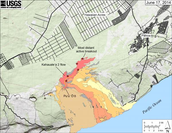
This Hawaiian Volcano Observatory map shows the Kahaualeʻa 2 flow (in pink) as of Tuesday, June 17. Red stars mark the fronts of the active breakouts — the most distant was 7.0 km (4.3 miles) straight-line distance northeast of the Puʻu ʻŌʻō vent. Older lava flows are distinguished by color: those from 1983–1986 are in gray, 1986–1992 in pale yellow, 1992–2007 in tan, 2007–2011 in pale orange and 2011–2013 in reddish orange. The active lava tube is shown with a yellow line (dashed where its position is poorly known). Click to enlarge.
When the flow resumed days later, it slowly reached 7.8 km (4.8 miles) northeast of Pu‘u ‘Ō‘ō before stalling again in January 2014.
Following the same “two steps forward–one step back” pattern, the flow front reached 8.3 km (5.2 miles) from the vent by early April before its movement was disrupted again.
The Kahauale‘a 2 lava flow advanced yet again through late April and early May 2014. This period, however, was accompanied by more profound pressurization within the magma chamber beneath Kīlauea, as indicated by summit inflation and extension, which led to a relatively high lava level within the lava lake at Kīlauea’s summit.
In the East Rift Zone, the increased pressure manifested itself as (or was reflected in) new lava flows from several spatter cones on the floor of the Pu‘u ‘Ō‘ō crater.
This renewed filling of the crater brought lava to within just a few meters (yards) of Hawaiian Volcano Observatory webcams and other equipment positioned on the north rim of Pu‘u ‘Ō‘ō . Sustained flows also topped much of the south rim of the crater, burying much of the southern flank of the Pu‘u ‘Ō‘ō cone beneath a carapace of new lava.
This period of heightened activity came to a sudden end on May 10, 2014, when an abrupt deflation and increase in seismicity at Kīlauea’s summit marked the release of summit pressurization, likely a result of the intrusion of magma beneath the surface just south of the volcano’s summit. New lava flows within and around Pu‘u ‘Ō‘ō quickly stagnated, and the forward momentum of the Kahauale‘a 2 flow was disrupted after it had reached 8.8 km (5.5 miles) northeast of Pu‘u ‘Ō‘ō .
Since late May, the summit of Kīlauea has been inflating once again, reaching a pressurization state similar to that prior to the May 2014 “intrusion.”
The summit lava lake has also risen to a level comparable to its level in early May. Despite this, the Kahauale‘a 2 flow has been even weaker than before, suggesting a fundamental change in the magmatic plumbing system. A handful of small breakouts, spread along the well-established lava tube within the flow, have crept forward since then, but as of mid-June 2014, had reached only 7.0 km (4.3 miles) from the vent.
With the current pressurized state of Kīlauea, and especially with the lack of much pressurization at Pu‘u ‘Ō‘ō , we can’t help but wonder whether it will result in another small intrusion beneath Kīlauea’s summit, or perhaps in something even more significant, such as the March 2011 Kamoamoa fissure eruption along the volcano’s East Rift Zone.
Then again, it may lead to nothing.
No matter how the current conditions on Kilauea play out, scientists at the Hawaiian Volcano Observatory will continue to monitor the volcano’s every move and will keep you informed about the Kahauale‘a 2 flow through our daily eruption updates (http://hvo.wr.usgs.gov/activity/kilaueastatus.php).
Kilauea activity update
A lava lake within Halema‘uma‘u produced nighttime glow that was visible via HVO’s webcam during the past week. The lava lake level rose slightly, reaching about 36 m (118 ft) below the rim of the Overlook crater by Thursday, June 19.
On Kīlauea’s East Rift Zone, the Kahauale‘a 2 flow remains active. The flow front stalled at 8.8 km (5.5 miles) northeast of its vent on Pu‘u ‘Ō‘ō in mid-May. On Tuesday, June 17, the most distant active flows were 7.0 km (4.3 miles) northeast of Pu‘u ‘Ō‘ō. In addition, several small spatter cones within the Pu‘u ‘Ō‘ō crater continued to produce glow.
There was one earthquake reported felt in the past week across the Hawaiian Islands. On Tuesday, June 17, 2014, at 6:05 p.m., HST, a magnitude-2.4 earthquake occurred 4 km (2.5 mi) southwest of Captain Cook at a depth of 13 km (8 mi).
—
Volcano Watch is a weekly column provided by scientists at the Hawaiian Volcano Observatory headquartered at the summit of Kilauea volcano. Visit the HVO website (http://hvo.wr.usgs.gov) for current Kīlauea, Mauna Loa, and Hualālai activity updates, recent volcano photos, recent earthquakes, and more; call (808) 967-8862 for a Kīlauea summary; email questions to askHVO@usgs.gov.
Sponsored Content


