

UPDATE 2: Alvin Continues to Slowly Strengthen
UPDATE 2, 5 PM, HST, Wednesday, June 26, 2019: NWS NATIONAL HURRICANE CENTER MIAMI FL
ALVIN CONTINUES TO SLOWLY STRENGTHEN
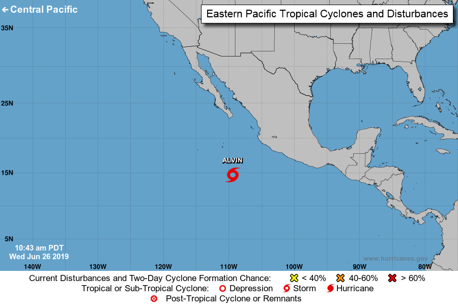
LOCATION: 14.4N 111.3W
ABOUT 595 MI: 955 KM S OF THE SOUTHERN TIP OF BAJA CALIFORNIA
MAXIMUM SUSTAINED WINDS: 50 MPH
PRESENT MOVEMENT: W OR 270 DEGREES AT 13 MPH
MINIMUM CENTRAL PRESSURE: 29.56 INCHES
WATCHES AND WARNINGS
There are no coastal watches or warnings in effect.
DISCUSSION AND OUTLOOK
At 5 p.m. HST, the center of Tropical Storm Alvin was located near latitude 14.4 North, longitude 111.3 West. Alvin is moving toward the west near 13 mph. A gradual turn to the WNW is expected on Thursday and this motion is expected to continue through Saturday.
Maximum sustained winds have increased to near 50 mph with higher gusts. Some additional strengthening is forecast during the next 24 hours. Weakening is forecast to begin on Friday, and
Alvin is expected to become a remnant low on Saturday.
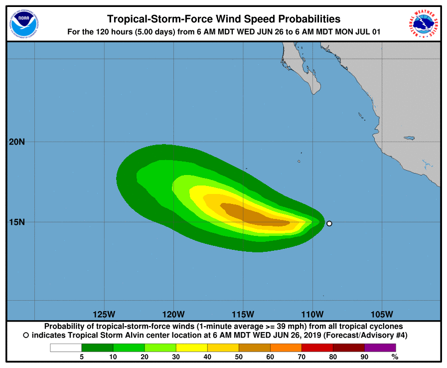
Tropical-storm-force winds extend outward up to 35 miles from the center.
The estimated minimum central pressure is 29.56 inches.
HAZARDS AFFECTING LAND
None.
UPDATE 1, 11 AM HST, Wednesday, June 26, 2019: NWS NATIONAL HURRICANE CENTER MIAMI FL
ALVIN SLOWLY STRENGTHENING
THERE ARE NO COASTAL WATCHES OR WARNINGS IN EFFECT
TROPICAL STORM CENTER LOCATED NEAR 14.3N 110.3W AT 26/2100Z POSITION ACCURATE WITHIN 30 NM
PRESENT MOVEMENT TOWARD THE WEST OR 260 DEGREES AT 12 KT
SUMMARY
LOCATION…14.3N 110.3W
ABOUT 515 MI…825 KM SW OF MANZANILLO MEXICO
ABOUT 595 MI…955 KM S OF THE SOUTHERN TIP OF BAJA CALIFORNIA
MAXIMUM SUSTAINED WINDS…45 MPH…75 KM/H
PRESENT MOVEMENT…W OR 260 DEGREES AT 14 MPH…22 KM/H
MINIMUM CENTRAL PRESSURE…1004 MB…29.65 INCHES
DISCUSSION AND OUTLOOK
At 1 a.m., the center of Tropical Storm Alvin was located near latitude 14.3 north, longitude 110.3 West. Alvin is moving toward the west near 14 mph. A gradual turn to the WNW is expected by Thursday night, and this motion is expected to continue through Saturday.
Maximum sustained winds have increased to near 45 mph with higher gusts. Some additional strengthening is forecast during the next 24 hours. Weakening is forecast to begin on Friday and Alvin is expected to become a remnant low on Saturday.
Tropical-storm-force winds extend outward up to 35 miles from the center.
The estimated minimum central pressure is 29.65 inches.
Alvin is a small tropical storm as indicated by a recent scatterometer pass that showed tropical storm force winds extending only about 30 nm from the center in the northern semicircle. This scatterometer data as well as an average of satellite intensity estimates from TAFB and SAB support an initial intensity of 40 kt.
Alvin has continued to move south of due west throughout the day, and the initial motion estimate remains 260/12 kt. Through 24 hours, little change was made to the NHC forecast track, as the cyclone is expected to move westward and then WNW around the southwestern periphery of a subtropical ridge through dissipation. The latest forecast track is on the southern edge of the guidance envelope through 36 hours, and has been shifted a little northward closer to the consensus aids from 48 to 72 hours.
Although dry air has been trying to entrain into the storm’s circulation today, deep convection continues to develop over the center. Some additional strengthening is still expected through 24 hours as the cyclone moves over warm SSTs in a low-shear and sufficiently moist environment. After 36 hours, the forecast track takes Alvin over progressively cooler waters and into a drier and higher-shear environment. This should result in steady weakening, with the cyclone likely becoming a remnant low by 72 hours, and dissipating by 96 hours. The new NHC forecast is near or a little below the latest dynamical and consensus intensity guidance.
8 AM HST, Wednesday, June 26, 2019: NWS Central Pacific Hurricane Center Honolulu HI
No tropical cyclones are expected during the next five days for the Central North Pacific between 140°W and 180°W.
5 AM, Wednesday, June 26, 2019: NWS National Hurricane Center Miami FL
Tropical Storm Alvin Discussion Number 4
ALVIN BECOMES THE FIRST TROPICAL STORM OF THE EAST PACIFIC SEASON
LOCATION…14.7N 109.4W
ABOUT 450 MI…725 KM SW OF MANZANILLO MEXICO
ABOUT 565 MI…915 KM S OF THE SOUTHERN TIP OF BAJA CALIFORNIA
MAXIMUM SUSTAINED WINDS…40 MPH…65 KM/H
PRESENT MOVEMENT…W OR 260 DEGREES AT 14 MPH…22 KM/H
MINIMUM CENTRAL PRESSURE…1005 MB…29.68 INCHES
WATCHES AND WARNINGS
There are no coastal watches or warnings in effect.
DISCUSSION AND OUTLOOK
At 5 a.m. HST, the center of Tropical Storm Alvin was located near latitude 14.7 North, longitude 109.4 West. Alvin is moving toward the west near 14 mph. A westward to WNW motion with some decrease in forward speed is expected over the next few days.
Maximum sustained winds have increased to near 40 mph with higher gusts. Some additional strengthening is forecast during the next day or so. Weakening is forecast to begin on Friday and Alvin is expected to become a remnant low on Saturday.
Tropical-storm-force winds extend outward up to 35 miles from the center.
The estimated minimum central pressure is 29.68 inches.
HAZARDS AFFECTING LAND
None.
Visible and passive microwave imagery this morning indicate that the center of the tropical cyclone is located farther south than previously estimated, possibly due to a reformation of the center. The center of the cyclone is now embedded near the deepest inner-core convection, and some overall improvement in the convective pattern is evident. Satellite intensity estimates indicate that the cyclone has reached tropical storm strength, and the initial intensity of 35 kt is based on the latest Dvorak estimate from SAB.
Alvin’s formation marks the third latest date of the development of the first named storm in the eastern Pacific basin during the satellite era (since 1966).
Alvin has turned a little south of due west and the initial motion
estimate is 260/12 kt. The new NHC forecast track over the first
couple of days has been adjusted southward, in large part due to the
more southerly reformation of the center. Despite this, the overall
track forecast philosophy has not changed. Alvin is expected to move
westward and then west-northwestward with a gradual decrease in
forward speed over the next few days along the southwestern
periphery of a subtropical ridge.
There remains about a 24-36 hour window for some additional strengthening to occur over warm SSTs in a low-shear and sufficiently moist environment. This environment, combined with the improving structure of the storm, supports raising the intensity forecast a little in the near term. The new NHC forecast is in good agreement with the dynamical models and the intensity consensus.
After 36 hours, the forecast track takes Alvin over progressively cooler waters and into a drier and higher-shear environment. This should result in steady weakening, with the cyclone likely becoming devoid of deep convection by 72 hours, and dissipating by day 5.
Sponsored Content


