


USGS to Survey Kīlauea Volcano From Summit to Kumukahi
Since the end of 2018’s volcanic activity, USGS Hawaiian Volcano Observatory scientists have wanted to resurvey Kīlauea Volcano’s ground surface to document changes brought about by the Puna eruption and summit collapse. Doing so would allow more accurate answers to questions about the total volumes of erupted lava and summit subsidence that occurred last summer.
By detailing these changes, it could also facilitate recovery and long-term risk mitigation projects by local partner agencies. A new survey would also allow comparison to earlier digital elevation data sets acquired by both helicopter lidar (light detection and ranging) and by UAS (unmanned aerial systems) imagery during Kīlauea’s 2018 eruption.
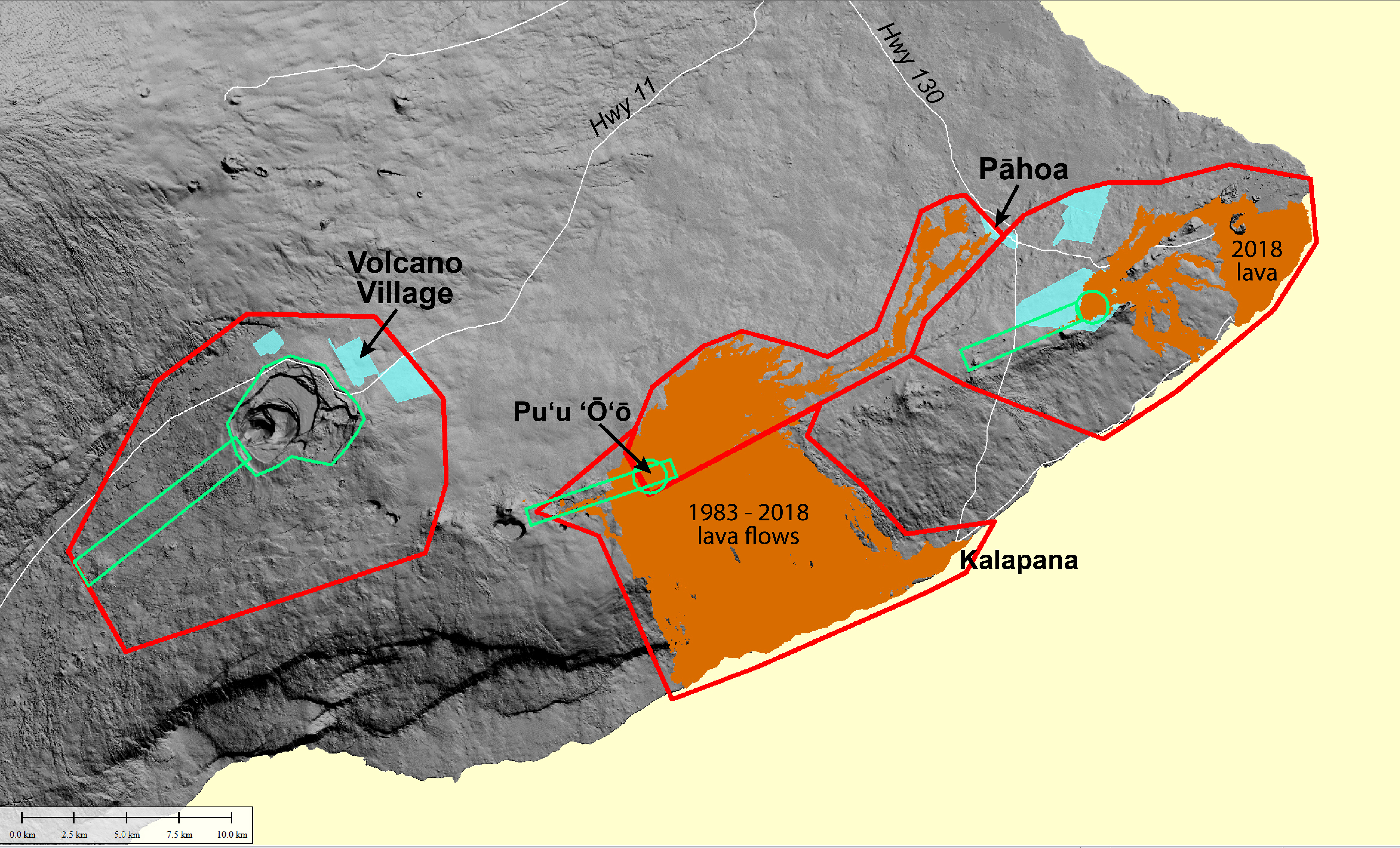
Areas on Kīlauea that will be covered by a helicopter lidar survey in June 2019. Red lines enclose areas over which the survey helicopter will fly at 1,300 feet above ground level. Green lines enclose areas over which the helicopter will fly at 500 feet above ground level. USGS map.
The resurvey Kīlauea will soon become a reality. The precision of this new survey will improve the accuracy of those earlier data sets.
The data will be acquired by a bright yellow helicopter flying over much of Kīlauea’s summit and East Rift Zone at an altitude of 1,300 feet above ground level (agl). The aircraft will fly in a lawn-mowing pattern, back and forth in a northeast-southwest direction. A few smaller areas on Kīlauea, namely parts of the East Rift Zone (Leilani Estates, Ala‘Ili Road, and Puʻu ʻŌʻō), the upper Southwest Rift Zone, and the summit caldera, will be flown at a lower altitude of 500 feet agl.
These helicopter flights are currently planned for the period of June 13 to 30, 2019, weather permitting.
The survey will use lidar technology capable of sending out hundreds of laser pulses per second. This should allow coverage of at least 30 laser pulses per square meter (ppsm), or about 3 pulses per square foot. The lower elevation flights will allow coverage of at least 100 ppsm, or about 9 pulses per square foot.
Why collect the lidar with such high-resolution? It’s the best way to detect and map vertical or near-vertical features, and there are a lot of them—from ground cracks everywhere, to fissures in the lower East Rift Zone (LERZ) and caldera walls at Kīlauea’s summit. High-resolution lidar is the best way to document and measure these potentially hazardous features.
A helicopter, rather than a fixed-wing aircraft, will be used for the survey because it can fly slower and acquire high-resolution lidar. The helicopter can also work even if there is high-altitude cloud cover.

During the lidar survey, equipment will be mounted on a bright yellow Hughes 500 helicopter like the one shown here. The helicopter will fly in a northeast or southwest direction over the survey areas depicted on the map. Photo courtesy of Windward Aviation.
The new lidar surface from this survey can be used to model where new lava flows may travel if renewed volcanic activity occurs in the LERZ. From an emergency management perspective, having these models was important during Kīlauea eruption responses in 2014-15 and 2018.
The bare-earth elevation model (digitally stripped of all vegetation) is the main interest of geologists because it will reveal geologic features such as faults and cracks that are not yet mapped. However, the lidar point cloud data from which it is derived will also contain other data, such as vegetation type and density. This could be a goldmine for biologists mapping flora on Kīlauea.
To illustrate the power of lidar, in a USGS 8 ppsm lidar survey of Glacier Peak volcano in Washington, it is psosible to differentiate between maple, alder, and fir trees in the vegetation points. Blackberries at the edges of open areas can also be detected. In California, lidar surveys are used to catalog vegetation that could fuel forest fires.
Along with lidar data, the helicopter will simultaneously collect four-band digital imagery (red-green-blue, or RGB, plus near-infrared). These multispectral images will also be useful to help detect geologic features and classify vegetation.
The final products of this survey, a digital elevation model and detailed imagery covering surveyed areas, will be made public and should be available by late 2019.
We understand that helicopter noise can be disruptive, so we will greatly appreciate affected residents’ patience and understanding as we collect this extremely important data to help mitigate future lava flow hazards. The survey should take only 8-10 days, weather permitting, to complete.
Volcano Watch is a weekly article and activity update written by US Geological Survey Hawaiian Volcano Observatory scientists and affiliates.
Volcano Activity Updates
Kῑlauea Volcano is not erupting and its USGS Volcano Alert level remains at NORMAL. For definitions of USGS Volcano Alert Levels, go online.
Rates of deformation, gas release and seismicity on Kīlauea have not changed significantly over the past week.
Since early March, GPS stations and tiltmeters at Kīlauea’s summit have recorded deformation consistent with slow magma accumulation within the shallow portion of the summit magma system. However, gas measurements have not indicated shallowing of large volumes of magma.
On Kīlauea’s East Rift Zone, GPS stations and tiltmeters continue to show motions consistent with refilling of the deep magmatic reservoir in the broad region between Puʻu ʻŌʻō and Highway 130. This trend has been observed since the end of the 2018 eruption, although there is an indication that this motion has been slowing down over the past couple weeks.
Sulfur dioxide emission rates on Kīlauea’s ERZ and summit remain low, but HVO continues to closely monitor gas emissions in both areas for any changes.
Two earthquakes with three or more felt reports occurred in the Hawaiian Islands this past week: a magnitude-2.8 quake 4 miles SE of Waimea at 7 miles depth on May 25 at 10:35 p.m. and a magnitude-3.4 quake 9 miles NE of Waialua at 16 miles depth on May 24 at 3:16 a.m.
Hazards remain at the lower ERZ and summit of Kīlauea. Residents and visitors near the 2018 fissures, lava flows, and summit collapse area should heed Hawai‘i County Civil Defense and Hawaiʻi Volcanoes National Park closures and warnings. Hawaiʻi County Civil Defense advises that lava flows from the 2018 eruption are primarily on private property; people are asked to be respectful and to not enter or park on private property.
The USGS Volcano Alert level for Mauna Loa remains at NORMAL.
HVO continues to closely monitor both Kīlauea and Mauna Loa for any signs of increased activity.
Sponsored Content


