

Ocean Sensors Help UH Researchers Understand Big Island Aquifers
Perch, Pike, Parrotfish, and Pompano were instrumental in helping University of Hawaiʻi at Mānoa researchers gain a better understanding of Hualālai aquifer on Hawaiʻi Island. The four marine electric-field receivers, dubbed with common fish names, are part of state-of-the-art technology used by researchers from ʻIke Wai, a large-scale, multidisciplinary project funded by the National Science Foundation’s Established Program to Stimulate Competitive Research (EPSCoR).

From left, Eric Attias and Jake Perez deploy the system. PC: University of Hawai‘i.
The nine-person research team conducted an eight-day marine survey and covered approximately 200 kilometers to gain a better understanding of how freshwater releases into the ocean from below the seafloor. Eric Attias, a postdoctoral researcher at the UH Mānoa served as chief scientist.
The backbone of the study uses a surface-towed marine controlled-source electromagnetic (CSEM) system called Porpoise that was recently developed by the Electromagnetic Laboratory at Scripps Institution of Oceanography.
“You have two novelties here, you have a very new system, in terms of worldwide, which is one-of-a-kind, and the second novelty is the capability of this system to detect deep submarine groundwater deposits. Hence, both the technology and its application are new,” said Attias.
Researchers can differentiate between fresh and salt water in submarine groundwater systems through the use of the new technology. CSEM is being used like MRI imaging to map the electrical resistivity of the groundwater structures along the coast up to about 500 meters below the seafloor.
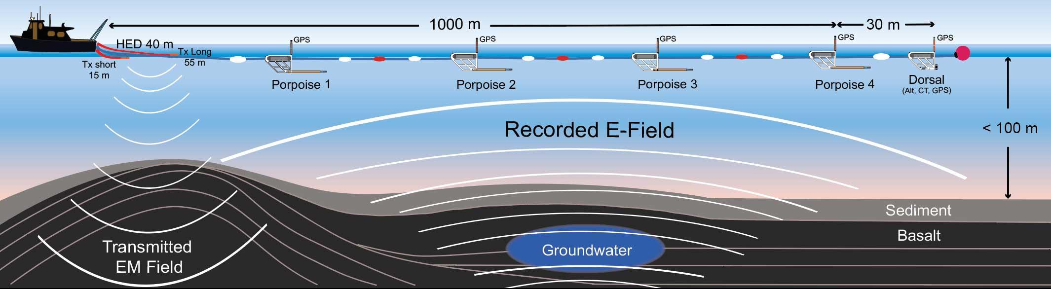
CSEM Porpoise System. PC: University of Hawai‘i.
“The work is in progress, but once I have solid results it will highlight a few things. First of all, the interconnectivity [of freshwater] between the land and the offshore environment. Second, it will show us, offshore where we have deposits of groundwater located. Which means we get their location, their lateral and vertical distribution, and how deep they can extend,” said Attias.
Sponsored Content


