

6 PM: Kalapana Vacation Rentals & Business Can Resume as Normal
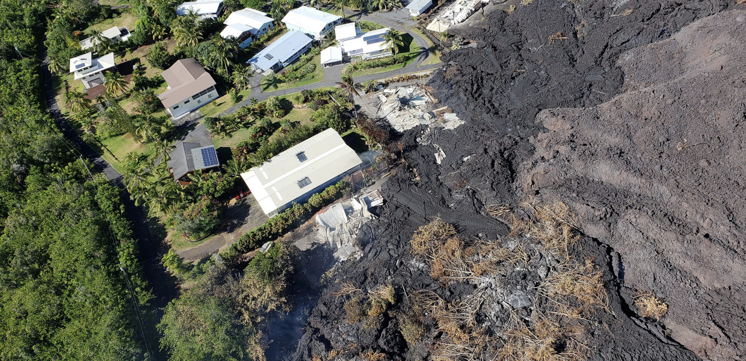
Hawai‘i County Fire Department photo taken June 30, 2018.
This news story will be updated throughout the day as new information becomes available and new articles will be added to the website’s “News” section. Previous information about ongoing events can be found in Big Island Now’s “Volcano Blog” section.
KĪLAUEA SUMMIT LIVESTREAM LINK
CLICK HERE FOR INTERACTIVE LAVA MAP FOR JULY 2, 2018
Monday, July 2, 2018, 6 p.m.: Kalapana Vacation Rentals & Business Can Resume as Normal
Map as of 12 p.m., July 2, 2018.

Click to enlarge
Given the dynamic nature of Kīlauea’s lower East Rift Zone eruption, with changing vent locations, fissures starting and stopping, and varying rates of lava effusion, map details shown here are accurate as of the date/time noted. Shaded purple areas indicate lava flows erupted in 1840, 1955, 1960 and 2014-2015.
Hawaiian Volcano Observatory reports that Fissure 8 continues to be very active and is feeding a lava channel to the ocean at Kapoho. The flow is producing a broad ocean entry along the shoreline, and is also oozing fresh lava at Kapoho Beach Lots. Fissure 22 is also active and producing a short flow. Gas emissions from the fissure eruption and laze at the ocean entry continue to be very high. The National Weather Service reports trade winds will push vog to the south and west side of the island.
Highway 130 will re-open to all traffic beginning at 8 a.m. Wednesday, July 3.
- Kamaili Road will be open to residents only
- Highway 137 will be open from Highway 130 north to Opihikao road
- MacKenzie State Recreation Area and the new lava flow areas remain closed
- Vacation Rentals as well as all businesses in the Kalapana area can resume normal operations
There will be a community meeting Tuesday, July 3, 2018, at 5 p.m. at the Pāhoa High School cafeteria.
Monday, July 2, 2018, 1 p.m.: Elevated Gas Levels
State of Hawai‘i Department of Health reports Elevated Gas Levels due to the ongoing eruptions and current weather in the lower East Rift and Pāhoa area. The National Weather Service forecast that light winds are causing Sulphur dioxide to fill in the area. Northeast tradewinds will build in later today and push winds to the southwest through the rest of the week and improve air quality.
Due to the high levels of gas, the following is provided for your awareness:
- Residents in the area affected are advised to shelter in place or leave the area.
- Do use your air conditioning and set to recirculate.
- Persons should reduce exposure by limiting outdoor activity.
- For current levels in your area view the Civil Defense or Department of Health websites.
A Pāhoa Community Meeting regarding the eruption will be held Tuesday, July 3 at 5 p.m. at the Pāhoa High School cafeteria. An American Sign Language interpreter will be available at the meeting.
Kīlauea Volcano Lower East Rift Zone
The eruption in the lower East Rift Zone (LERZ) continues with no significant change during the past 24 hours.
Fountains from Fissure 8 spatter cone continue to supply lava to the open channel with intermittent small, short-lived overflows. The spatter cone is now about 180 feet tall at its highest point, and fountains rarely rise above that point.

This thermal map shows the fissure system and lava flows as of 6 a.m. on Friday, June 29, 2018. The fountain at Fissure 8 remains active, with the lava flow entering the ocean at Kapoho. Very small, short flows were observed today near Fissure 22. The black and white area is the extent of the thermal map. Temperature in the thermal image is displayed as gray-scale values, with the brightest pixels indicating the hottest areas. (Click to see large map.)
At the coast, the northern margin of the flow field is still oozing pasty lava at several points in the area of Kapoho Beach Lots. Lava was entering the sea over a broad area this morning primarily on the northern side of the entry area.
As shown by the June 29 thermal map of the flow field (above), the lava channel has crusted over about .5 miles inland of the ocean entry; lava oozing from the flow’s molten interior into the ocean along most of its broad front.
Fissure 22 is spattering about 65 to 87 yards above a conical spatter cone and feeding a short lava flow that is moving slowly to the northeast along the edge of earlier flows.
Pele’s Hair and other lightweight volcanic glass fragments from the lava fountain at Fissure 8 continue to fall downwind of the fissure, dusting the ground within a few hundred yards of the vent. High winds may waft lighter particles to greater distances. Residents are urged to minimize exposure to these volcanic particles, which can cause skin and eye irritation similar to volcanic ash.

Kīlauea lower East Rift Zone lava flows and fissures, June 30, 3 p.m. Shaded purple areas indicate lava flows erupted in 1840, 1955, 1960 and 2014-15. USGS map (click to enlarge).
HVO field crews are on site tracking the fountains, lava flows, and spattering from Fissure 8 as conditions allow and are reporting information to Hawaii County Civil Defense. Observations are also collected on a daily basis from cracks in the area of Highway 130; no changes in temperature, crack width, or gas emissions have been noted for several days.
Volcanic gas emissions remain very high from Fissure 8 and 22 eruptions. Continuing trade wind conditions are expected to bring VOG to the southern and western parts of the Island of Hawaii. VOG information can be found at https://vog.ivhhn.org/.
The ocean entry is a hazardous area. Venturing too close to an ocean entry on land or the ocean exposes you to flying debris from sudden explosive interaction between lava and water. Also, the lava delta is unstable because it is built on unconsolidated lava fragments and sand. This loose material can easily be eroded away by surf, causing the new land to become unsupported and slide into the sea. Additionally, the interaction of lava with the ocean creates “laze.” a corrosive seawater plume laden with hydrochloric acid and fine volcanic particles that can irritate the skin, eyes and lungs.
Magma continues to be supplied to the Lower East Rift Zone. Seismicity remains relatively low in the area with numerous small magnitude earthquakes and low amplitude background tremor. Low amplitude tremor increased slightly on June 29 associated with renewed activity at Fissure 22. Higher amplitude tremor is occasionally being recorded on seismic stations close to the ocean entry.
Additional ground cracking and outbreaks of lava in the area of the active fissures are possible. Residents downslope of the region of fissures should heed all Hawai‘i County Civil Defense messages and warnings.
Kīlauea Volcano Summit
At 1:24 a.m., July 2, a collapse explosion event occurred at Kīlauea’s summit. Radar indicated an ash-poor plume rose approximately 1,200 feet above the ground surface. The energy released by the event was equivalent to a M-5.3 earthquake. After the collapse/explosive event, seismicity dropped abruptly from a high of 20 to 25 earthquakes per hour (many in the magnitude 2 to 3 range) prior to the collapse explosion down to five or fewer earthquakes per hour afterwards. Inward slumping of the rim and walls of Halemaʻumaʻu continues in response to ongoing subsidence at the summit.
Sulfur dioxide emissions from the volcano’s summit have dropped to levels that are about half those measured prior to the onset of the current episode of eruptive activity. This gas and minor amounts of ash are being transported downwind, with small bursts of ash and gas accompanying intermittent explosive activity.
For forecasts of where ash would fall under forecast wind conditions, consult the Ash3D model output here.
Information on volcanic ash hazards and how to prepare for ash fall maybe found online at http://www.ivhhn.org/information#ash (health impacts) OR https://volcanoes.usgs.gov/volcanic_ash/ (other impacts).
6 a.m.: Highway 130 to Reopen July 3
Hawaiian Volcano Observatory reports that Fissure 8 continues to be very active and is feeding a lava channel to the ocean at Kapoho.
The flow is producing a broad ocean entry along the shoreline, and is also oozing fresh lava at Kapoho Beach Lots.
Fissure 22 is also active and producing a short flow.
Gas emissions from the fissure eruption and laze at the ocean entry continue to be very high.
The National Weather Service reports trade winds will push vog to the south and west side of the island.
Highway 130 will reopen to all traffic beginning at 8 a.m., Tuesday, July 3.
Kamaili Road will be open to residents only.
Highway 137 will be open from Highway 130 north to Opihikao Road.
McKenzie State Recreation Area and the new lava flow areas remain closed.
Vacation Rentals as well as all businesses in the Kalapana area can resume normal operations.
There is no immediate danger, but persons in the area are reminded to be on the alert for changing conditions and to monitor Civil Defense messages.
VIDEO: On June 30, 2018, at 2:51 p.m., a collapse/explosion event occurred at Kīlauea’s summit. An ash-poor plume rose about 500 feet above the ground and drifted to the southwest. The energy released by the event was equivalent to a M-5.3 earthquake. This video, taken by a USGS observer at Volcano House, captures rockfall (brown dust visible in the center right) along the bluff and a small plume rising from the Halema‘uma‘u crater. Since May 16, these collapse/explosion events have occurred on average, about every 28 hours. As magma from the shallow reservoir beneath the summit drains into the East Rift Zone, it slowly pulls away support of the rock above it. The crater floor responds by incrementally collapsing, which produces these events.
VIDEO: Whirlwind above the Fiissure 8 lava channel, in Kīlauea Volcano’s lower East Rift Zone: In the Leilani Estates subdivision, Hawaiian Volcano Observatory field crews monitoring Fissure 8 captured this video of a whirlwind above the lava channel. The vortex of rapidly swirling air entrained hot lava, flinging it yards away. The scientists maintained a safe distance, using a telephoto lens to take this video. The whirlwind lasted about 10 minutes, starting and stopping without warning.
1:50 a.m.: Explosive Eruption at Kīlauea Summit
Hawaiian Volcano Observatory reports that an explosive eruption at Kīlauea Summit has occurred at 1:25 a.m. The resulting ash plume may affect the surrounding areas. The wind may carry the ash plume to the southwest toward Wood Valley, Pahala and Ocean View.
The danger from this eruption is ash fallout. The major response is to protect yourself from fallout.
If you are at home, stay indoors with the windows closed. Turn on your radio and listen for updates from authorities.
If you are in your car, keep the windows closed. Ash fallout may cause poor driving conditions, due to limited visibility and slippery driving conditions. Drive with extreme caution, or pull over and park.
After the hazard has passed, do check your home, and especially your catchment system for any impact that may affect your water quality.
Sponsored Content


